
The secrets of Nagsasa Cove
Every beach has a long and complex story to tell, and secrets to divulge, if only we become more observant and listen more closely. I could spare only a few hours of chatting with the locals, followed by more hours of fact checking and map checking. But let me share what I learned during a short stay at this pristine cove in San Antonio, Zambales. 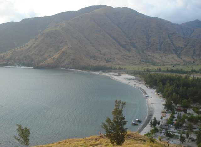 Here are ten things you might not know about Nagsasa because you were so busy enjoying the beach, the scenery, and the food. 10. Rainforest Aetas and rocky beaches In the 1980s, the mountain slopes around Nagsasa Cove were covered with tropical rainforest and inhabited by Aeta people, as they were for hundreds of years. The shoreline was mostly rocky, with short patches of beach here and there. Some distance beyond the shore (as indicated in old maps of the cove) was a rich coral reef, prolific with all kinds of fish and marine life. There was logging, but not on a large scale. 9. Practice area for US warplanes If my Aeta informant is to be believed, these forested mountains served as bombing practice areas for US warplanes. As he recalls, they were given enough warning not to leave their homes when the practice runs started, but there were frequent cases when “some of our people working in the forests” got hit by shrapnel. Unlike the more famous Crow Valley range, the area was apparently not an official part of any US military reservation. But just across the mountains were Clark Air Force Base to the northeast, and Subic Naval Station – base of the US Seventh Fleet base – to the southeast, apart from the US Navy communications station in San Miguel further up north, but still within San Antonio town. Thus, it was likely that the mountains around the cove were also occasionally used for practice runs. 8. Pinatubo eruption brings hell to Nagsasa On June 12, 1991, Mount Pinatubo started to erupt explosively, leading to massive ashfalls that covered a big number of towns in the Zambales-Tarlac-Pampanga-Bataan boundaries, including Nagsasa and the neighboring coves of Anawangin, Talisayin, and Silanguin. The Aeta people, who lived in small bands all throughout the Zambales-Bataan mountains, suffered severe dislocation due to the eruption and the ensuing lahar hazards. It is said that a big number of them were killed on the slopes, either because they could not quickly evacuate to a safe distance or refused to do so because it was their sacred homeland. Others retreated to safer ground or were rounded up into refugee centers. Aeta old-timers still recall those hellish days, when whitish-gray ash blanketed the mountains around the cove. When the rains came, the volcanic ash mixed with the soil and turned into slushy lahar that flowed down the slope. They say the ashfall-turned-lahar eventually killed much of the forest and other vegetation. They remember numerous wild boar and deer, leaping hither and thither but with nowhere to hide amid the dying trees. 7. Lahar covers old shoreline and creates new beach Six months later, after the 1991 rainy season had come and gone, the US warplanes were gone too. But so did the former ecosystem, including the old shoreline. Tons of lahar, washed downstream by the rains, overran the old shoreline and created a new beach a few hundred meters beyond. The new beach sparkled with billions of tiny glass beads, black and white sands of hornblende, feldspar, quartz, and other minerals fresh from the Pinatubo cauldron, like a micro-universe coming out of the big bang. The new beach was fresh and clean, but almost totally lifeless. It must have wiped out the coral reefs that now lay underneath, leaving only an empty stretch of rippling sand dunes, underneath the now slightly shallower sea. 6. Life finds a way In the past twenty years since the Pinatubo eruption, the new beach at the cusp of the Nagsasa cove gradually became alive again. You can see this in pieces of sea grass, a scattering of small shells, strands of coral growing slowly on the seabed, tiny crustaceans that burrow holes and zip across the sand, occasional catches of fish and shellfish, and other signs of recovering marine life. In the Nazasa uplands – the hills surrounding the cove – it took some time before vegetation returned. This time, however, a hardier assemblage struggled to survive on the slopes: low-growing wiry grasses, sparse clumps of tall grasses and Japanese bamboo, and isolated trees that lined up in thin galleries along the upper gullies. 5. Returning Aeta families strive to make a living A few dozen Aeta families (some say 20, others 70) eventually came down to the Nagsasa valley and coast, eking out new livelihoods because their mountain forest was no more. As the old-timers recalled, at first they gathered and sold charcoal of which there was plenty—whatever remained of their old forest. Others became piece-rate reforestation laborers, paid by the DENR for each narra, mahogany, or dagang tree they planted. Some of them fished along the shore with homemade spears. Others made bamboo handicrafts to be sold as souvenirs to tourists. 4. Aeta beach vs Disney World An Aeta told me this story, but I’m not sure if it’s true as I haven’t found any independent corroboration: It appears that some years back, a Taiwanese barge arrived at the Nagsasa Cove with workers and began landing heavy construction materials on the shore. The local Aetas were reportedly told that the Taiwanese planned to build some sort of Disney World. The Aetas formed a community organization and held dialogues with government agencies to resist the project. Eventually, my informant said, the DENR disapproved the project. The barge left, hauling back the construction materials to where they came from. “They seemed in a hurry to get out, they even left some stuff for us to use,” my informant recalled with a chuckle. More than that, he said, the local Aetas gained enough confidence, and lobbied the DENR to give them permission to set up their own beach resorts in Nagsasa. I don’t know if the same process occurred in nearby Anawangin and Talisayin coves, where beach resorts now proliferate. But in Nagsasa, it appears, the DENR approved the necessary paperwork and gave the Aetas the go-signal. According to some accounts, the first resorts appeared in 2006. And so today, at least some of the resorts in the cove are owned and operated by Aeta families. 3. Ilocano speakers Some travelogues tell you that the local population of San Antonio speaks Tagalog. That’s only partly true; in most cases, their native language is Ilocano. That’s probably due to Spanish-sponsored Ilocano settlement of the area from the 1830s onwards. I talked to the Aetas in Ilocano; it probably helped me in gaining their confidence. 2. Not pine but casuarina trees Most travelogues will also tell you about the mysterious appearance and prolific growth of pine trees along the whole stretch of the Anawangin and Nagsasa beaches after the Pinatubo eruption. I’m pretty sure the groves of “pine trees” I saw in Nagsasa are not real pine trees, but agojo of the Casuarina family. Agojo is strikingly similar to pine, especially in the needle-like leaves. But it is a flowering tree and a hardwood, while pine is a conifer and softwood. Agojo and many other Casuarina species thrive in seashore conditions – poor soils, brackish water, strong winds. They reproduce fast and are now considered invasive species in some countries. These agojo traits probably explain the “pine trees that suddenly appeared” in Nagsasa and other nearby coves. 1. Wild Horse Creek “A river runs through it,” most visitors and travelogues would say. It’s more of a creek ending in shallow tidewater pools than a river, although further upstream are rapids and falls. In old maps, it’s called Wild Horse Creek. Follow its headwaters, and soon you’ll discover that there’s an alternative route by land between Nagsasa and the outside world: through a six-hour trek across the mountains via Cinco Picos, with the famed Subic Bay at the other end.
 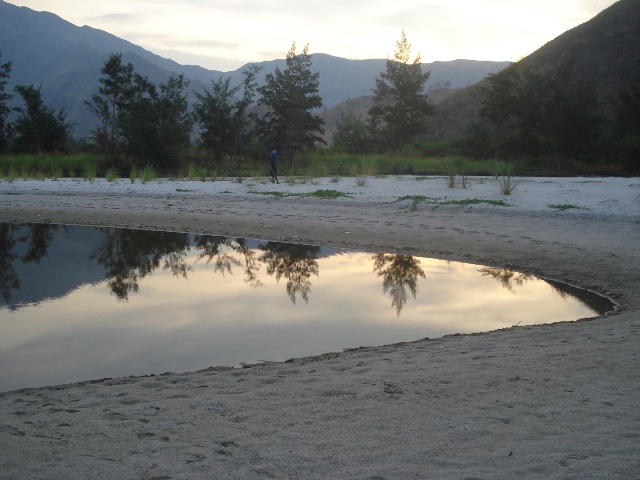 I left Nagsasa with a sense of immense awe, not just at the majestic forces of nature, but at the resilience that underlies the seeming fragility of ecosystems and of the indigenous communities that live with them. Tourists have started to arrive by the boatloads, which isn’t surprising because the place is incredibly pristine and awe-inspiring. The Aetas would certainly welcome earning a bit more than they do now, but let us respect the integrity of Nagsasa’s ecosystem, its community, its history. By all means, find a way to visit Nagsasa. Go there to recharge. Go there to continue your work while recharging. Go there to nurse a broken heart. Go there to discover a new love. Cavort on the water from dawn to dusk. Feast all day long on broiled fresh fish, perhaps with a bottle of beer from the icebox to quench the heat of long and lazy afternoons. Sleep under the stars, with only your duffel bag as pillow. By all means, enjoy your stay to the fullest. But spend a bit of time, too, to listen to the faint voices around you. Their messages murmur with the soft night surf. Hold on to them, tuck them into your heart, and bring them home with you. They are your best souvenirs. – YA, GMA News
