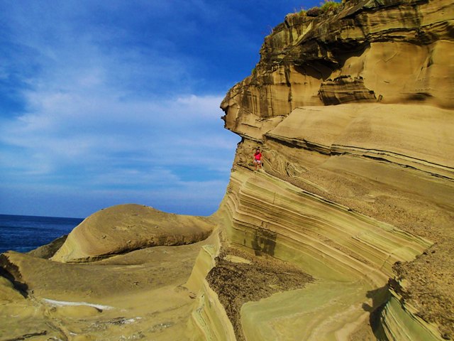
Biri Island's sedimentary rock formations, eroded and shaped by millions of years of waves and currents. Photos by Alvin Faustino
I first saw pictures of Biri Island from photos taken by backpacker and photographer friends on Facebook, and I told myself that I would see it one day. Biri is one of the tiny islands in San Bernardino Strait, which separates Sorsogon and Samar Island, and is known for its gorgeous rock formations. So when another friend said he was going backpacking in Samar and that Biri Island was one of his stops, I cancelled all other plans and jumped at the chance. It was an unplanned trip with no clear itinerary. He went ahead on a Friday night because I still had class, but I followed the next day. I took the 14-hour long land trip from Cubao, Quezon City to Irosin, Sorsogon, and then transferred to a jeepney that took me to Matnog, Sorsogon, the southernmost tip of Luzon. It’s so near Visayas that you can actually see Samar from afar, and the people there speak Bisaya. I was hoping to catch the only boat to Capul Island which leaves at 11 a.m, but I learned that the boat was leaving later in the afternoon. We didn’t have time to waste, so we decided to go to Biri Island instead that day. With the help of kind men at the port, I was lucky to find a small boat going directly to Biri, instead of having to go to the mainland. The boat was already sailing away, but the men called the boat and it came back for me. It was actually a cargo boat, but the boatmen were kind enough to let me hitch for P150. I sat on top of sacks of rice and onions and amongst bags of chips and sari-sari store goods for the next two hours and a half. My friend, who was coming from mainland Samar, met me at Biri. We found a house near the port to stay in, which the landlady rented out to guests at P500 per room. The room was big and comfortable with a balcony where you could hang up your wet clothes and sniff the night air. After a quick lunch at a nearby carinderia, we set off to the rock formations that the island is known for. We learned that there were two sites—Bil-ad and Magasang. We contracted a habal-habal (a motorcycle with extended seats at the back, commonly used in the countryside as a means of transportation) for P200 each for the entire afternoon. (We learned later that a ride costs only P40, but we thought the extra tip would be of help to the driver, so we didn’t really mind.) We drove past coconut trees and lush greenery for about 30 minutes until we got to the site. The habal-habal driver dropped us off by the roadside, and told us that we would have to walk—and wade in the water—the rest of the way.
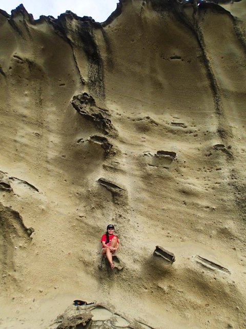
The author, halfway up one of Biri's famous rocks.
So we did—and there they were, seven rock formations of different shapes and sizes, lining the seashore about 500 meters from the roadside. According to a
study from the University of the Philippines' National Institute of Geological Sciences, the rocks are sedimentary rocks from the Early Miocene Period, making them about 5 million to 23 million years old. The formations are separated from each other by water, smaller rocks, seaweed and mini-saltwater pools. At low tide, the water is about knee-deep, but is deeper in the mini-pools, so you must avoid them. There’s a cement bridge from the roadside to the rocks, but it’s unfinished so you still have to wade the rest of the way. We started from the leftmost rock, which was shaped like a gigantic table, wide and covered with grass at the top, with a base in the middle. My friend and I climb mountains, so it was just natural for us to want to see what was up there. From experience, we knew that the best views are always at the top. So we went up, crossed to the side facing the sea, and found ourselves looking down at the Pacific Ocean from a 300-meter drop. From up there, one can see the blue of the ocean brushing against the rugged shape of the rocks down below. Seeing the view, I was reminded of the strong current and the big waves that I encountered on the boat on the way to the island. Millions of years of those waves and currents shaped the rocks like a miniature Grand Canyon. We stayed far from the edge though. It was not my first time to be near a cliff or ravine, but it was a bit nerve-racking because there was a flock of seagulls at the top and they were swooping down on us, as if to attack us. We figured that the birds might have nests amongst the rocks.
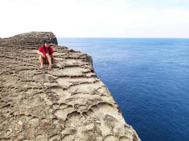
At the top, overlooking the ocean—but not too close to the edge.
The second rock was shaped like an obtuse triangle. We climbed it too, but we didn’t explore it like the first, because we didn’t have much time left. It was getting late in the afternoon and we were warned that high tide was approaching. Climbing was easy; I think it was just that we consumed all our time taking pictures of the rocks from all angles. We were too amazed. True enough, when we started wading back, the water was now up to my waist and still rising. It made it much harder to walk, as the rocks underneath were slippery. We stopped by a mini-pool and had a little dip, then made the long slippery walk back to where the habal-habal driver was waiting for us. The driver then brought us to another spot. The rock formations were also separated from the road by a body of water, but this time the area was planted with a mixture of green and yellowish mangroves. Like the first site, there was a wooden bridge to the rock formations, but the bridge was unfinished, so wading in the water was still necessary. We were told that it was muddy and it was already high tide, so we opted not to go on, and instead took pictures of the sunset and the mangroves. We did realize that we should have started our exploration earlier in the day. A half-day isn’t enough to explore and fully appreciate Biri's rocks. It was tempting to stay and go back the following day, but we had the whole province of Samar to cover and other places to visit, so we called it a day. After spending the night outside with locals who were drinking and eagerly sharing stories of their lives in the remote island, and us listening intently, the seabreeze punctuating our conversations, we left Biri early the following day to go to mainland Samar to catch another boat to Capul Island, another remote island in the Pacific. But that is another adventure story for another time.
— BM, GMA News 
