
Filtered By: Topstories
News
Santi packs 150kph winds, may hit CLuzon Saturday
(Updated Oct. 30 4:30 a.m.) Typhoon “Santi" (international name: Mirinae), the fourth cyclone to enter the Philippine area of responsibility in October, has maintained winds of 150kph and is expected to hit provinces in central Luzon on Saturday morning while bringing heavy rains and winds to Metro Manila, the state weather bureau said Thursday night. In its Friday 12:30 a.m. (amended) weather bulletin, the Philippine Atmospheric Geophysical and Astronomical Services Administration (Pagasa) said Santi was last spotted 660 kilometers east of Baler, Aurora province and is moving westward towards central Luzon at 22 kph. Santi maintained its strength, packing maximum sustained winds of 150 kph near the center and gustiness of up to 185 kph. 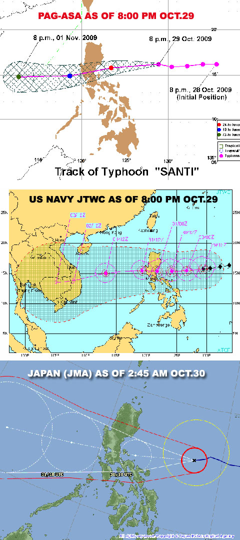 Santi's location Based on the current Pagasa forecast, Santi’s center is expected to be 180 km east of Baler, Aurora province by Saturday morning, cross Central Luzon throughout the day, and be on its way out at 240 km west northwest of Manila by Sunday morning. Public storm signal no. 2 has been hoisted over Aurora, Quirino, Nueva Ecija, Bulacan, Rizal, Northern Quezon and Polilio Island. Under storm signal no. 1 are the provinces of Isabela, Ifugao, Benguet, Nueva Vizcaya, La Union, Pangasinan, Tarlac, Zambales, Pampanga, Bataan, Laguna, Cavite, Batangas, Lubang Is., the rest of Quezon, Camarines Norte, Camarines Sur, Albay, Sorsogon, Catanduanes, and Metro Manila. “Kahit ang sentro ni Santi ay dito dumaan sa pagitan ng central at northern Luzon, mararamdaman natin ang ulan at hangin na dala nitong si Santi dito sa Metro Manila," said Pagasa spokesperson Nathaniel Cruz. (Although Santi’s center would pass somewhere between central and northern Luzon, we will feel here in Metro Manila the rains and winds brought by Santi.) Foreign weather agencies such as the US Navy Joint Typhoon Warning Center (JTWC) and the Japan Meteorological Agency (JMA) also forecast Santi to pass through central Luzon on Saturday. STORM WARNING SIGNALS

Various weather agencies forecast Santi to move across central Luzon and out to the South China Sea.
See a more detailed description for each storm warning on Pagasa's website.
When do we call a storm a storm? State weather forecasters use this guide when classifying weather disturbances visiting Philippine territory. 'Santi' has maximum winds of a tropical typhoon. Source: Pagasa
