Filtered By: Topstories
News
TS Nina now a typhoon, moves closer to Cagayan
Tropical Storm Nina (Prapiroon) intensified into a typhoon early Tuesday as it continued to move closer to the Cagayan area in Northern Luzon, state weather forecasters said.
But PAGASA added their forecast models show that Nina may change course and move away from the country without making landfall. 

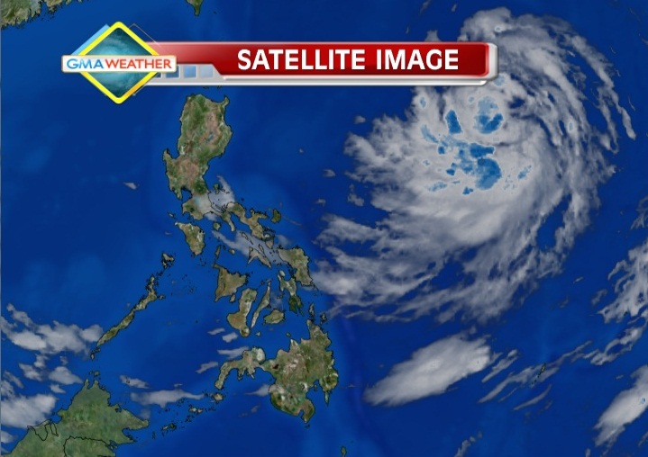
Satellite image of Typhoon Nina as of 7am, Oct. 9.
"TS Nina has intensified further as it continue to traverse the northeastern section of the Philippine Area of Responsibility (PAR). Nina is still too far to affect the country directly, but the Bicol region and the whole Visayas will have light to moderate rains or thunderstorms," explained GMA resident meteorologist Nathaniel "Mang Tani" Cruz.
"With the weakening southwest wind flow, The rest of Luzon and Mindanao will have brief rainshowers and thunderstorms. In Metro Manila, partly cloudy with high possibility of afternoon or evening rainshowers or thunderstorms is expected," he added.
"Si Nina ay lumakas lalo at ganap na typhoon na (pero) ito ay malayo para makaapekto sa anumang bahagi ng ating bansa," PAGASA forecaster Bernie de Leon said in an interview on dzBB radio.
He said that, while Nina is presently moving westward, there is a chance it may head north and eventually exit via the PAR's northern border. No storm signals yet
Rainfall forecast for the 24 hours ending 8 a.m., October 10
De Leon also assured the public that there is no storm warning signal raised in the Philippines at this time.
"Although lumakas ito at typhoon category may kalayuan ito, wala tayong signal na nakataas sa ngayon," he said.
But de Leon said rain may be expected over Bicol, Visayas and Davao, while Metro Manila can expect relatively good weather.
The Japan Meterological Agency's (JMA's) 5:45 a.m. update described Typhoon Nina as "strong." PAGASA bulletin
PAGASA's 5 a.m. bulletin indicated that, as of 4 a.m., Typhoon Nina was estimated at 1,050 km east of Cagayan, with maximum winds of 120 kph near the center and gustiness of up to 150 kph.
It said Nina is forecast to move west at 15 kph.
"Bicol, Visayas and Davao region will have occasional light to moderate rain or thunderstorms. Metro Manila and the rest of the country will be partly cloudy with brief rain showers or thunderstorms," it said.
Moderate to strong winds blowing from the north to northwest will prevail over Luzon and coming from the northwest to west over Eastern Visayas and Eastern Mindanao.
The coastal waters along these areas will be moderate to rough, PAGASA said.
Elsewhere, winds will be light to moderate coming from the northwest to west with slight to moderate seas. — TJD, GMA News
More Videos
Most Popular


