
Filtered By: Topstories
News
Typhoon Nina moves W-NW, fishermen warned vs big waves
State weather forecasters on Wednesday warned fishermen and small seacraft in the country's northern and eastern seaboards against big waves as Typhoon Nina (Prapiroon) moved west-northwest.
PAGASA forecaster Bernie de Leon said that, while Typhoon Nina is still too far to directly affect the country, it is enhancing strong- to gale-force winds that could genereate big waves.
'Recurve trajectory' away from PAR
"TY Nina remains a slow-moving system northeast of the Philippine Area of Responsibility (PAR). Owing to its distance to Luzon island including its expected recurvature —from northwest to northeast movement within the next two days— TY Nina does not pose a direct threat to any part of the archipelago, with respect to rainfall. However, its elongated trough will affect central and southern parts of Luzon, Visayas and northern Mindanao where occasional light to moderate rains or thunderstorms will prevail today," said GMA resident meteorologist Nathaniel "Mang Tani" Cruz.
"Sea conditions will be rough to very rough over the northern and eastern seaboards of Luzon and Visayas. Gale warning is now in effect in these areas and small seacraft are advised not to venture out into the sea," he added. Typhoon Nina is forecast to turn and head in a northeastern path away from the PAR by this weekend:
Forecast trajectory of Typhoon Nina as of 7 a.m., October 10
No storm signals yet
"Dahil may kalayuan si Nina, wala tayong warning signal sa any part of the country. Subali't may gale warning dahil may kataasan ang alon sa seaboard ng Northern Luzon at eastern seaboard din hanggang sa Visayas," de Leon said in an interview on dzBB radio.
He warned fishermen and small seacraft should not venture out to sea in these areas.
De Leon also said the rain falling over Metro Manila and parts of Luzon is not due to Typhoon Nina but due to a thunderstorm.
PAGASA bulletin 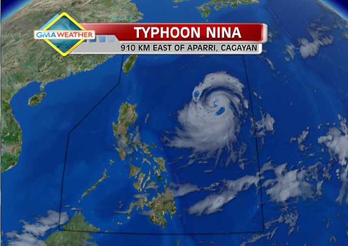
Satellite image of Typhoon Nina as of 7 a.m., October 10
PAGASA's 5 a.m. bulletin said that as of 4 a.m, Nina was estimated at 910 km east of Aparri, Cagayan, with maximum sustained winds of 120 kph near the center and gustiness of up to 150 kph.
It said Typhoon Nina is forecast to move west-northwest at 7 kph.
"Metro Manila, Central Luzon, Bicol Region, Calabarzon, Western Visayas, Zamboanga Peninsula, Northern Mindanao and Caraga will have occasional light to moderate rain or thunderstorms. The rest of the country will be partly cloudy with brief rain showers or thunderstorms," PAGASA said.
It added moderate to strong winds blowing from the north to northwest will prevail over Luzon and Eastern Visayas and coming from the northwest to west over the rest of the country.
The coastal waters throughout the archipelago will be moderate to rough.
On the other hand, PAGASA said strong to gale-force winds may affect the seaboards of Northern Luzon and the eastern seaboard of Luzon and of Visayas.
"Fishing boats and other small seacrafts are advised not to venture out into the sea while larger sea vessels are alerted against big waves," it said. — TJD, GMA News
