
Filtered By: Topstories
News
'Pablo' makes landfall over Davao Oriental, 24 areas under signal no. 3
Typhoon Pablo (Bopha) made landfall over Baganga town in Davao Oriental before 5 a.m. Tuesday, and 24 areas were placed under Storm Signal No. 3 as the cyclone started sweeping across Mindanao and the Visayas.
PAGASA forecaster Bernie de Leon said the typhoon did not immediately weaken upon landfall but may gradually lose strength when it hits more land mass.
"Nag-landfall ito 4:45 a.m. sa Baganga," de Leon said in an interview on dzBB radio.
He said heavy rain of up to 27 mm per hour had been recorded in the first three hours of Tuesday.
De Leon said the typhoon's path may include Agusan del Sur, Misamis Oriental, Siquijor, Negros Oriental, and the Sulu Sea. It is expected to exit via Palawan as early as Thursday night.
As of 4 a.m. Tuesday, PAGASA said Typhoon Pablo was estimated at 40 km east of the eastern coast of Davao Oriental, with maximum sustained winds of 175 kph near the center and gustiness of up to 210 kph.
It said Typhoon Pablo was moving at 26 kph and is expected to be 180 km southwest of Roxas City by Wednesday morning.
By Thursday morning it is expected to be 230 km northwest of Puerto Princesa City. By Friday morning it is expected to be 780 km west of Metro Manila.
Storm signals
Areas under Storm Signal No. 3 include:
- Southern Leyte
- Bohol
- Negros Oriental
- Siquijor
- Southern Cebu
- Surigao del Norte
- Siargao
- Surigao del Sur
- Dinagat Province
- Agusan del Norte
- Agusan del Sur
- Misamis Oriental
- Camiguin
- Bukidnon
- Davao Oriental
- Compostela Valley
- North Cotabato
- Lanao del Sur
- Lanao del Norte
- Misamis Occidental
- Zamboanga del Norte
- Zamboanga del Sur
- Davao del Norte
- Samal Island
Under Signal No. 2 are:
- Rest of Cebu
- Camotes Island
- Iloilo
- Guimaras
- Capiz
- Leyte
- Biliran
- Negros Occidental
- Davao del Sur
- Sultan Kudarat
- Zamboanga Sibugay
- Maguindanao
Under Storm Signal No. 1 are:
- Palawan
- Calamian Group Of Islands
- Ticao Island
- Masbate
- Northern Samar
- Eastern Samar
- Western Samar
- Aklan
- Antique
- Basilan
- Sarangani
- South Cotabato
PAGASA said Typhoon Pablo may bring rainfall of 15 to 30 mm per hour (heavy to intense) within its 600-km diameter.
It advised residents in low-lying and mountainous areas under storm signals to be alert against possible flash floods and landslides.
Residents in coastal areas under public storm warning signals 2 and 3 were also warned against storm surges particulary in the provinces of Surigao del Sur, Surigao del Norte, Dinagat, Bohol and Leyte.
Waves in these areas may reach three to six meters, it said.
Fishing boats and other small seacraft were also advised not to venture out into the eastern seaboards of Visayas and Mindanao. 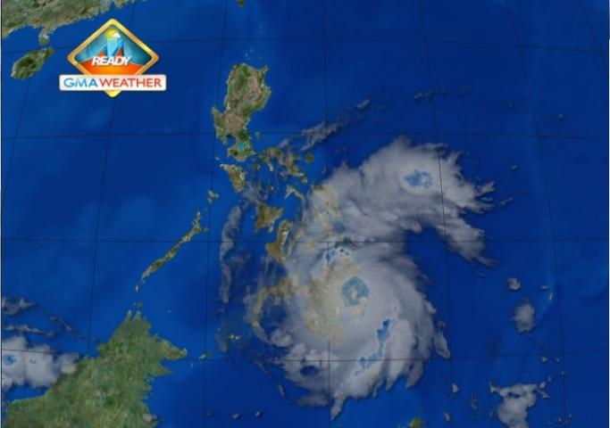
Satellite image at 7 am, Dec. 4
Gale warning
PAGASA said strong to gale force winds associated with the surge of the northeast monsoon may affect the northern and eastern seaboards of Northern Luzon and the eastern seaboards of Central and Southern Luzon.
Also, it said Mindanao, Central Visayas, Leyte provinces, Negros Occidental, Iloilo, Capiz, Guimaras and Biliran will experience stormy weather with rough to very rough seas.
The rest of Eastern and Western Visayas, Masbate including Ticao island and Palawan including Calamian group of islands will have rain with gusty winds with moderate to rough seas.
The rest of MIMAROPA and Bicol region will be cloudy with light to moderate rain showers or thunderstorms.
Cagayan valley and CAR will have cloudy skies with light rains while Metro Manila and the rest of the Luzon will be partly cloudy with brief rain showers or thunderstorms.
Moderate to strong winds blowing from the northeast will prevail over the rest of the country with moderate to rough seas. — With a report from Shaira Panela/KG/HS/YA, GMA News
