
Filtered By: Topstories
News
PAGASA: Weakened 'Pablo' to make landfall again, heads to Palawan
Although weakened after plowing through Mindanao and Visayas, Typhoon Pablo (Bopha) is now heading for Northern Palawan and may make landfall there Wednesday morning, state weather forecasters said. 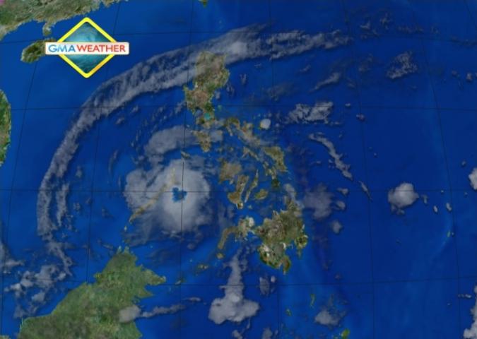
Satellite image at 8 am, Dec. 5
PAGASA forecaster Ricky Fabregas said Northern Palawan and the Calamian group of islands are under Storm Signal No. 3, while several other areas are under Storm Signals 1 and 2. "Base sa ating pag-analyze ang landfall between 7 and 9 a.m., sa northern part ng Palawan (Based on our analysis, it may make landfall between 7 and 9 a.m. at the northern part of Palawan)," he said in an interview on dzBB radio. He said parts of southern Luzon, including Metro Manila, may expect rain from Typhoon Pablo. But he said their models do not indicate Typhoon Pablo changing course and heading for Central or Southern Luzon. There is no other weather disturbance threatening the Philippines after Typhoon Pablo, he added. He said Pablo may exit the Philippine Area of Responsibility as early as Thursday night. "Yan nakikita nating paglabas base sa speed na 24 kph (Our models show that at 24 kph, it may exit the Philippine Area of Responsibility as early as Thursday night)," he said. "Palawan including Calamian Group of Islands, Antique, Iloilo, Guimaras, Bohol, Siquijor, Southern Cebu and Negros Provinces will experience stormy weather with rough to very rough seas," PAGASA said in its 5 a.m. bulletin. Mindoro provinces including Lubang Island, Romblon, the rest of Panay and Cebu, Lanao Del Norte, Misamis Occidental, Zamboanga del Norte and Camiguin will have rains with gusty winds with moderate to rough seas. Bicol, CARAGA and Davao regions and the rest of Visayas will be cloudy with light to moderate rain showers or thunderstorms while Metro Manila and the rest of Luzon will have cloudy skies with light rain. The rest of Mindanao will be partly cloudy with brief rain showers or thunderstorms. Moderate to strong winds blowing from the southeast to northeast will prevail over the rest of the country with moderate to rough seas. Storm signals As of 4 a.m., Typhoon Pablo was estimated at 180 km east of Puerto Princesa City, with maximum sustained winds of 130 kph near the center and gustiness of up to 160 kph. By Thursday morning it is expected to be 440 km northwest of Puerto Princesa City. By Thursday afternoon it is expected to be 780 km West of Calapan, Oriental Mindoro. Under Storm Signal No. 3 are Northern Palawan and the Calamian Group of Islands. Under Signal No. 2 are: - Rest of Palawan - Antique - Iloilo - Guimaras - Bohol - Siquijor - Southern Cebu - Negros Oriental - Negros Occidental Under Signal No. 1 are: - Occidental Mindoro - Lubang Island - Oriental Mindoro - Romblon - Aklan - Capiz - Rest of Cebu - Lanao del Norte - Misamis Occidental - Zamboanga del Norte - Camiguin PAGASA said Typhoon Pablo may bring rainfall of 10 to 18 mm per hour (heavy to intense) within its 400-km diameter. It advised residents in low-lying and mountainous areas under public storm warning signals to be alert against possible flash floods and landslides. Also, it said those living in coastal areas under public storm signals 2 and 3 should be alert against big waves or storm surges. Also, it said strong to gale force winds associated with the surge of the northeast monsoon enhanced by Typhoon Pablo may affect the seaboards of Northern and Central Luzon and the eastern seaboard of Southern Luzon. "Fishing boats and other sea vessels are advised not to venture out into the seaboards of Southern Luzon, Visayas and Mindanao," it added. — ELR, GMA News 