

ADVERTISEMENT
Filtered By: Topstories
News
Dry no longer, Holy Week to have mix of sun and rain
+
Make this your preferred source to get more updates from this publisher on Google.
Summer may be here, but a sudden downpour on Monday in Manila was a harbinger of weather to come this Holy Week. The whole country can expect isolated thunderstorms throughout the week, with a low-pressure area (LPA) expected to bring rain to Visayas and Mindanao towards the weekend, state weather forecasters said late Monday. Holy Week is usually associated with heat and relentless sun throughout the archipelago. The coming days will be wetter than usual. But Filipinos are getting accustomed to unexpected weather, which many attribute to climate change. Several powerful typhoons have occurred in Mindanao in the last several months, upending the region's happy assumptions about its placid climate. LPA: 'Slim' chance of becoming cyclone
PAGASA administrator Nathaniel Servando said this week's low pressure area may enter the Philippine area of responsibility (PAR) on Maundy Thursday, but rain may not fall until at least Black Saturday. "On the afternoon of Maundy Thursday (March 28), an LPA is expected to enter the Philippine Area of Responsibilty but will still have no direct effect on any part of the country. So on Maundy Thursday up to Good Friday (March 28-29), the whole country will still experience generally good weather with isolated thunderstorms mostly in the afternoon or evening," Servando said in the agency's special weather outlook for the Holy Week.
On Black Saturday, Servando said the LPA may approach Southeastern Mindanao in the morning and make landfall in the evening. But he assured that PAGASA's initial analysis indicates the LPA has just a "slim" chance of developing into a tropical cyclone.
It will then bring light to moderate rain showers and thunderstorms over the whole of Mindanao, becoming moderate to heavy rains over Caraga and Davao regions.
"The LPA will then move towards Central Visayas crossing the area on Easter Sunday (March 31) and is expected to bring light to moderate rain showers and thunderstorms over Southern Luzon, Visayas and Mindanao becoming moderate to heavy rains over Western Visayas," he said.
Rains from 'tail-end of cold front'
Servando also said the diffused tail-end of a cold front will bring "occasional light to moderate rainshowers and thunderstorms" over Cagayan Valley, Central Luzon and Quezon province until Tuesday morning.
From Tuesday to Wednesday, "generally good weather condition associated with warm and humid temperature is expected throughout the country aside from isolated thunderstorms mostly in the afternoon or evening."
"The coastal waters throughout the archipelago will be generally slight to moderate except during thunderstorms throughout the outlook period with the exception of the Northern Seaboard of Northern Luzon which will have moderate to rough seas (Monday and Tuesday)," Servando said.
Weather Central outlook Meanwhile, GMA News Online has compiled the following 6-day weather outlook for key places across the country, along with forecast high and low temperatures. The chart is based on Weather Central forecast data as of Monday evening, March 25.
Please note that this chart is just a rough guide and is subject to change, as more weather data comes in over the following days. Readers are advised to regularly log on to the GMA News Weather Page for the latest updates. The site also provides regular updates on other places across the country, via drop-down menu and interactive map. 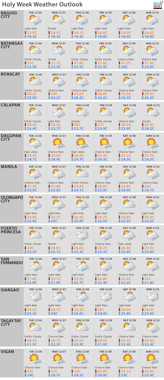
— TJD/HS, GMA News
