
I dream of the Pasig: Notes, hopes, and plans for a river of potential
Recently I asked two friends to join me to ride the Pasig River Ferry.
It was their first trip. As an MMDA safety officer briefed everyone on the proper way to use a life jacket, they shot me nervous looks.
Their worries are not unfounded. The first time I rode the ferry in 2009, the captain asked passengers to return to our seats inside the boat as we approached an informal settlement. A boat attendant informed me that kids along the bank were known to slingshot feces at unsuspecting commuters.
My guests took deep breaths and braced themselves as the engine came alive., but when we started moving and the scenes along the river unfolded, their eyes jumped around and within moments they were enthusiastic converts.
“Wow there’s a breeze!”
“I really thought it would smell!”
“I didn’t know there were birds in the city!”
My friends went from skeptical to surprised and then to inspired. As we continued down the river, we found ourselves rattling off ideas: "It would be awesome to paint a mural there." "That over there could be a small park." "I would love to see a performance there." "I could ride my bike to that station." "Those gardens could be planted everywhere..."
Traversing the Pasig feels like entering a secret garden. Abandoned buildings keep watch on vacant lots overgrown with lush, wild foliage. Industrial infrastructure stands frozen in time or barely used. Tiny islands of hyacinth cluster together, giving the water a swampy, unchartered feel.
Small expressions of life find their way into the landscape. Graffiti and declarations of love pepper the steep retention walls. A security guard fishes to stave off boredom. Local boats sport unique designs and add a bit of color to the otherwise grey corridor.
Viewing the city from the water is to see a city that has turned its back on its most beautiful edge. The river is a sleepy part of the city for now, but in this thick band of neglect lies the greatest untapped potential we have in Metro Manila today.
The Pasig River stretches 25 kilometers and is just slightly longer than EDSA. It connects Manila, Mandaluyong, Makati, Taguig and Pasig. In an increasingly dense urban environment, the Pasig River is a primary corridor for transportation, biodiversity and the environment, public space, and new infrastructure, including housing.
It is provides a totally different narrative from the rest of Metro Manila. The river feels like a breath of fresh air with a wide, uninterrupted view. It is a break for the eyes and the mind and for a moment we feel relaxed; this is why we need nature in the city.
In Manila’s early history, water transport for goods and people was prevalent, leading the city’s urban planner Daniel Burnham to declare that an estero “should be remembered is not only an economical vehicle for the transaction of public business; it can become as in Venice, an element of beauty.”
Whether it is still true today, the Venice waterways represent urban life connected through and fostered by water. I have never been to Venice, but I have been to a “Venice of Asia”—Bangkok.
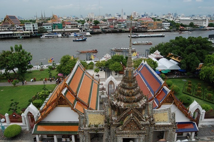
Bangkok
Bangkok has a homegrown water transportation system. Built and expanded by a number of kings, the canal system also grew from early transportation needs.
From my hotel in one of the large shopping centers I walked to a canal stop just 15 minutes away. I waited on the platform for no more than five minutes when a long, thin boat came ripping through the canal, sending water shooting of its hulls. It didn’t stop but slightly paused; the only indication of allotted boarding time was a man’s syncopated blows on a whistle.
A larger commuter boat line runs along the Chao Phraya River, which is home to many of the major hotels and retail establishments. The docking stations are located conveniently for both tourists and commuters, shuttling a mix of passengers between ancient temples, modern shopping complexes, and other transportation nodes. I rode a water taxi from Asiatique, an outdoor mall to the Saphan Taksin station which connects directly with the Sky Train (BTS). The escalator for the Sky Train is meters from the boat dock and within minutes I was aboard the train and on my way back to the hotel.
The Bangkok system illustrates two important principles; it is multimodal and it connects a variety of uses at different scales, producing a highly useful system.
New York City
Other cities are only recently making a concerted effort to revive waterfronts and water transportation. Post-industrial cities like New York City have abandoned waterfronts where factories, ports, and working communities used to thrive. New York City released its strategic waterfront action plan, "Vision 2020," in 2011. The plan provides a 10-year vision for 520 miles of the city’s shoreline and includes 130 identified priority projects and is an interagency initiative.
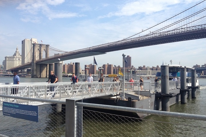
Only on a visit to New York City last summer did I get to experience the water taxis. I was staying with a friend in Red Hook, Brooklyn and needed to get into Manhattan for a lunch meeting. I decided to walk 30 minutes along the newly redeveloped waterfront. The City didn’t skimp on ideas- there are water parks for kids, mobile swimming pools, outdoor photography exhibits to cover scaffolding, public art, food truck parks, picnic tables and bbq pits. When I reached Dumbo I found electronic kiosks selling tickets to the water taxi into South Street Seaport in the Financial District. I waited 10 minutes for the next boat, gave my ticket and took a spot outside on the back. As I took in the approaching skyline against a clear blue sky, I felt like a sentimental tourist, but looking around I saw other passengers sitting quietly, calmly, taking a moment to enjoy the fact that our commute involved the Statue of Liberty to our left and the Williamsburg bridge to our right.
Revitalizing what's ours
Manila has the existing vibrant water culture of Bangkok but will need a strategic approach like New York City to realize its potential as an urban asset. We need to link the ferry stations to existing transportation nodes as well as to areas of social importance, such as schools, houses, markets. This means, we need to build efficient transportation hubs and use smaller boats that travel faster and adjust to passenger demand. Despite major environmental improvements the waterways still need some TLC. We need to build more pedestrian and vehicular bridges across the Pasig River and give the public reasons to frequent the waterfront with accessible, beautiful, dynamic places to pass the time.
Regardless of the tasks, Manila has to find its own approach to waterfront revitalization. Design is a cultural exercise. We cannot copy and paste concepts from abroad. We need to redevelop our relationship with the water to understand what we want to achieve. I recommend we start with a ferry ride — VC/BM, GMA News
Julia Nebrija is an urban planner living and working in Manila. She is the Executive Director of Viva Manila and the Chair of the Inclusive Mobility Network. Follow her on Instagram and Twitter.
