
Filtered By: Topstories
News
No interaction seen between TS Karen and LPA, but rains still expected
Tropical storm (TS) Karen (international codename Sanba) and a low pressure area (LPA) west of Luzon are not likely to interact as they are too far away from each other, PAGASA forecasters assured the public on Wednesday.
However, both weather systems are expected to draw monsoon rains into the eastern part of the Philippines. Residents in affected areas are warned to be careful of flash floods and landslides. 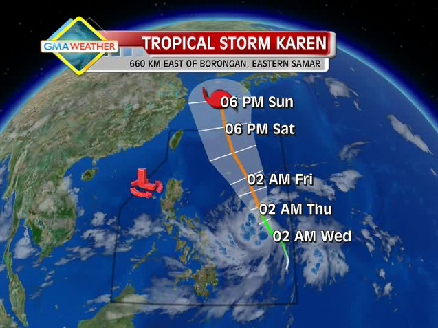
The relative positions of TS Karen (green line) and the LPA off Bataan (red letter L) as of 2:00am, September 12, courtesy of Weather Central. Also shown is the forecast track for Karen, which is expected to leave the Philippine Area of Responsibility by Saturday evening.
"TS Karen, the LPA and the southwest monsoon will bring occassional moderate to heavy rains over the Ilocos Region, Palawan, Eastern Visayas and northeastern Mindanao in the CARAGA region, possibly triggering flash floods and landslides," explained GMA resident meteorologist Nathaniel "Mang Tani" Cruz.
"The rest of the country will experience light to moderate rains. Gale warning is up over the eastern seaboard of Mindanao and small seacraft are advised not to venture out into the sea," he added.
Metro Manila is expected to be partly cloudy to cloudy, with light to moderate rain and thunderstorms, and light to moderate winds blowing from the southwest and from Manila Bay.
PAGASA forecaster Jun Galang said that Karen may intensify slightly, but is unlikely to become a typhoon.
When asked about the chances of Karen and the LPA interacting with each other over dzBB radio, Galang said, "Wala po. Ang isa sa East Philippine Sea, ang isa sa West Philippine Sea naman."
But he also warned of strong to gale-force winds associated with Karen over the eastern seaboards of Visayas and Mindanao.
He cautioned fishing boats and other small seacraft not to venture out to sea, while larger sea vessels must stay alert against big waves.
PAGASA's 5:00am bulletin said Karen was estimated 660km east of Borongan, Eastern Samar, as of 4:00am.
It packed maximum sustained winds of 65kph near the center and gustiness of up to 80kph, and is forecast to move north-northwest at 15 kph.
The Japan Meteorological Agency (JMA) indicated that Karen may move north and eventually northwest. Forecast data obtained by GMA News Online from Weather Central shows that Karen may be expected to leave the Philippine Area of Responsibility (PAR) by the weekend.
On the other hand, PAGASA said the LPA was estimated at 240 km west of Zambales. — TJD, GMA News
