Filtered By: Topstories
News

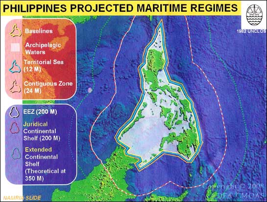
RP in last minute scramble to beat UN deadline on territorial claim


(Last of two parts)
First of two parts: Arroyo neglect, gov't infighting jeopardize RP's territorial claim MANILA, Philippines - A month before the May 13, 2009 deadline, the government intends to submit a claim before the UN over the country's extended continental shelf, which includes the resource-rich Kalayaan Island Group. If the UN upholds this claim, the Philippines would have the exclusive right to exploit the KIG’s vast natural resources, including an estimated 200 billion barrels of oil. The KIG is part of the disputed Spratly Islands in the South China Sea also being claimed wholly or in part by China, Taiwan, Vietnam, Malaysia and Brunei. The huge amounts of oil, natural gas, minerals and polymetals, such as gold, silver, iron and nickel, off the seas of the KIG could “greatly contribute to the growth of the economy and uplift the socio-economic condition of the Philippines," said the University of the Philippines Institute of International Legal Studies (UP-IILS). But the prize that is the KIG will not come easy. Laying claim to the extended continental shelf requires a complex and concerted series of scientific, diplomatic, and legislative efforts. Scientists and academics estimate the process could take from three to 10 years and eat up billions of pesos. If the Philippines misses the deadline, it will lose its claim forever. Stressing the importance of the claim for an extended continental shelf, Prof. Harry Roque, an international law expert, says: “The majority of oil we derive today is no longer from land territory but from the continental shelf." The UNCLOS defines continental shelf as “the seabed and subsoil of the submarine areas that extend beyond its territorial sea." It is the natural underwater extension of the land up to the point where it either gradually descends or drops off into the ocean floor. Under UNCLOS, a continental shelf of up to 200 nautical miles from the archipelagic baseline automatically belongs to a State and no proof of claim is required. A continental shelf that goes beyond 200 nautical miles is called the outer limits or the extended continental shelf. States may claim an extended continental shelf of up to 350 nautical miles from the baseline. To prove that the continental shelf extends beyond 200 nm, a State would have to conduct hydrographic and geoscientific studies and submit the data to the UN Commission on the Limits of the Continental Shelf (CLCS). Some parts of the KIG are about 230 nautical miles from Palawan. Atty. Henry Bensurto, head of the Commission on Maritime and Ocean Affairs (CMOA) Secretariat, says the government plans to submit to the CLCS on April 13, 2009 the technical data proving that the KIG and Scarborough Shoals are part of the country’s extended continental shelf. But Prof. Teodoro Santos, formerly of the UP National Institute of Geological Sciences (NIGS) had urged the government to submit the claim by 2007, “since the CLCS has to review the submissions and make relevant suggestions, for the State to respond to." Santos, in a paper presented to the UP-IILS in 2002, identified three areas where the Philippines could claim an extended continental shelf: the KIG west of Palawan; Scarborough Shoal (Isla Bajo de Masinloc) west of Zambales; and Benham Rise, off the Bicol Region in the Pacific Ocean. Of these three areas, he said KIG is the “most promising with respect to petroleum and natural gas." In terms of the equivalent in billion barrels of oil within the area of the KIG, he said the Chinese have the highest estimate at 100 to 200 billion barrels, with Russian sources estimating a low of seven billion barrels. “The Scarborough shoal is made up of mid-oceanic ridges formed during the extension of the South China crust, which are presently adding to the growth of Western Luzon by accretion. Similarly, the Benham Rise is an extinct volcanic ridge added into the eastern margin of Luzon," said Prof Mario Aurelio of the UP-NIGS. He added, “The strongest pieces of evidence the Philippines can present for its claim over these areas are geological, geophysical and tectonic data." The extent of the continental shelf is measured from the country’s baseline, the line connecting the basepoints that define, in longitude and latitude, the archipelagic boundaries. But the bill amending and redefining the archipelagic baseline remains pending in Congress. The existing baseline law, passed and amended in the 1960s, used the Treaty of Paris to define Philippine boundaries. The Treaty of Paris is the 1898 agreement in which Spain ceded the Philippines to the United States. The baseline law needs to be amended and harmonized with UNCLOS provisions, in particular the doctrine of archipelagic states which draws a straight archipelagic baseline “joining the outermost points of the outermost islands and drying reefs of the archipelago." All Congress needs to do is adjust the country’s baseline using UNCLOS’ Article 47, which says that basepoints must be part of the main archipelago, and must not be more than 100 nautical miles long. But the bill amending the baseline, House Bill 3216 authored by Cebu Rep. Antonio Cuenco, got caught up in the controversy that recently surrounded the Spratly Islands and the Joint Maritime and Seismic Undertaking (JMSU) between the Philippines and China. As a result of the various amendments to it, the Cuenco bill now includes within the baseline both Scarborough Shoal and the KIG which are not part of the main archipelago. “Instead of merely correcting the technical and clinical aspects of the baseline, somehow it has broadened to include territorial issues and when you include territorial issues it gets complicated," Bensurto said. Approved on second reading, the Cuenco bill drew protests from China. “If the Philippine side forcefully puts Scarborough Shoal and some other NANSHA reefs and islands inside the baseline of Philippine territorial sea, it will…. disturb China-Philippine cooperation in the area, exerting negative impact on the healthy development of our bilateral relations," said the Chinese démarche or official position dated December 2007, a copy of which was sent to Cuenco by the Philippine embassy in China. The bill had to be thrown back to the committee on foreign affairs for further debates and possible revisions following China’s protest. Hearings are scheduled to resume on April 4. At the Senate, Sen. Antonio Trillanes IV filed a counterpart bill, which has not been acted upon. Congress does not need to pass the baseline law before May 2009, but the UN will still need a revised baseline as a reference point when deciding on the Philippine claim. “For as long as you’re not clear with your baseline, then there’s difficulty moving forward," Bensurto pointed out. “The baseline is the first step in putting your archipelagic house in order." A clear baseline helps draw the line separating national and international waters and defines the limits of Philippine responsibility. All maritime regimes or zones are reckoned from the baseline. The 12-mile territorial sea is the area where the State enforces its laws and exploits its resources. The 24-mile contiguous zone, beyond the 12-mile territorial sea, is where the State has the right to pursue smugglers, illegal fishers, illegal immigrants, and customs and tax evaders. The 200-mile exclusive economic zone is where the State has the right to exploit and develop the resources in the sea. The 200 nautical mile continental shelf is where the State can exploit the resources all the way down to the seabed. According to CMOA’s Bensurto, these various maritime zones represent an additional 93 million hectares of water that are the responsibility of the Philippine government. “When your territory is confused and your baseline is confused, it is also confusing to your law enforcement agencies. In a contiguous zone, it's a quarantine and immigration area, if you don't know where that line is, you don't know when to shoot a ship and when not to shoot a ship," Bensurto explained. “The whole point is to harmonize the (baseline) law with the UNCLOS." Last December, the various member agencies of CMOA agreed to adopt the position that the country’s baseline would be the lines enclosing the main archipelago (see CMOA illustration). KIG as well as Scarborough Shoal would be treated as “regimes of islands" that are part of Philippine territory but outside the baseline. Besides, even if KIG and Scarborough Shoal are not within Philippine baseline, they will still form part of the country’s extended continental shelf. KIG is considered part of Palawan province and are part of Philippine territory by virtue of Presidential Decree 1596. Whatever moves the government takes regarding KIG and Scarborough Shoal, however, it would have to take into account neighboring countries, which also consider the islands part of their own territories or continental shelves. Hence, alongside the scientific and legislative efforts must come diplomatic negotiation. Bensurto pointed out that the filing of a claim with the CLCS will not settle territorial disputes. In fact, the UN body will not rule on a claim if it involves disputed territory. Suzette Suarez, formerly with UP-IILS and now with the CLCS, agreed with Bensurto, saying: “The CLCS will not examine and qualify a submission by any State in cases where a land or maritime dispute exists unless there is prior consent given by all States that are parties to the dispute." Suarez added: “If the Philippines claims at least 200 nm of continental shelf, it will already stand to have overlaps in some areas of the continental shelf with Palau, Indonesia, Malaysia, Brunei. Vietnam, China (and/or Taiwan) and Japan." In the KIG, the issue is not one of overlapping continental shelves between adjacent or opposite states but one of territorial dispute among the different claimant states. The same is true for Isla Bajo de Masinloc (Scarborough Shoal) since it is disputed by the Philippines and China (and Taiwan). Since Benham Rise is located on the Pacific side of the Philippines, which is without any opposite State within 400 nm, it will stand to have no issue of overlap. “The government must settle conflicts of interest with other states," said the late legal luminary and UP law professor Haydee Yorac in a roundtable discussion on the Philippines’ maritime jurisdictions in 1991. “As good fences make good neighbors, treaties and conventions which establish clear boundaries of power and operation will minimize interstate disputes." - Luz Rimban, Booma Cruz, Yvonne Chua, Ellen Tordesillas, Chit Estella and Jennifer Santiago VERA Files is put out by veteran journalists taking a deeper look into current issues. Vera is Latin for "true."