
Filtered By: Scitech
SciTech
How kites are being used to save PHL coral reefs
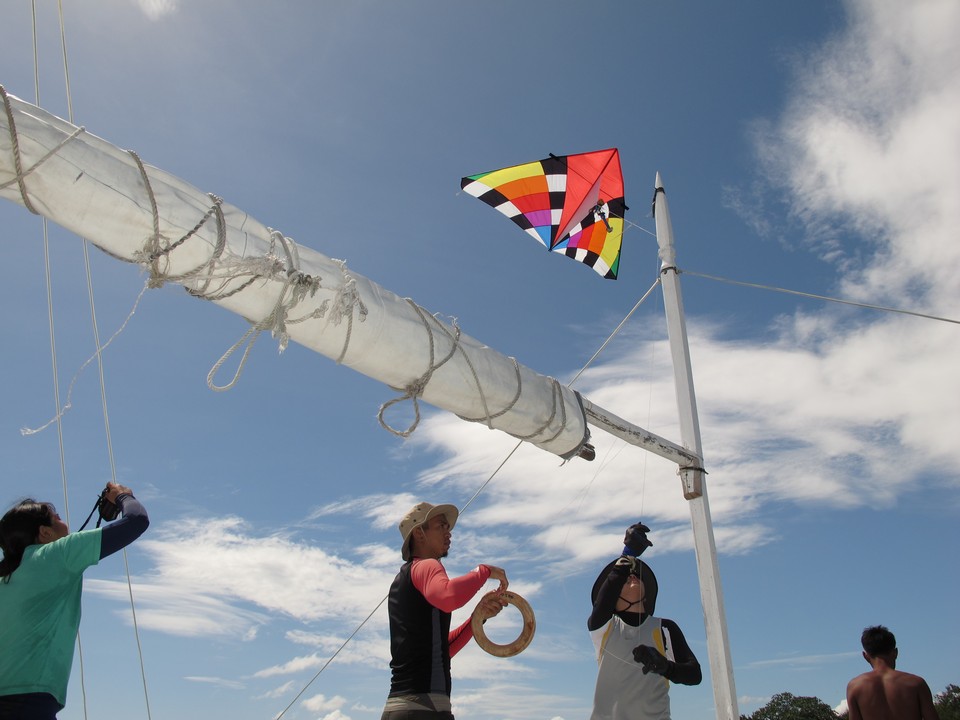
Kites have been used for hundreds of years to observe the skies, but now Filipino scientists and engineers are using them to observe our oceans. The brainchild of scientists and engineers from University of the Philippines, De La Salle University, and the Mapua Institute of Technology, the Automated Rapid Reef Assessment System (ARRAS) is designed to survey large reef areas in a short amount of time, low-cost, and to be easy to dismantle and transport.
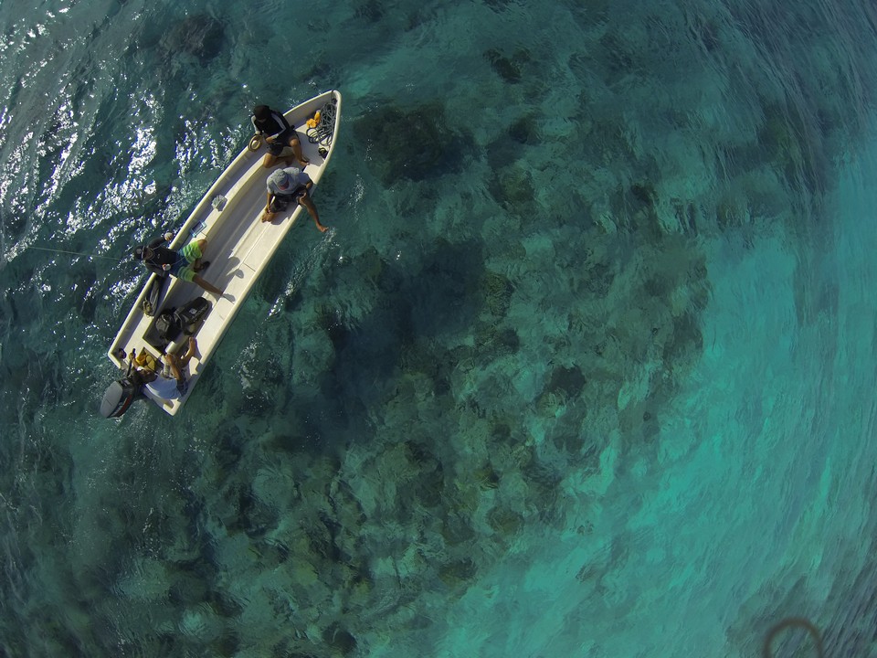
This aerial photography system consists of a small digital camera and GPS unit attached to a stabilizer, which is then attached to a kite. The kite deployment team flies the kite from the survey boat and controls its movement. The camera is programmed to take photos once every second to coincide with the GPS readings recorded.
What do marine scientists need aerial photos for?
The aerial photos, combined with dive surveys, allow scientists to view an area at different scales, giving them a better understanding of the area. The aerial photos also serve as permanent visual records.
"Since [ARRAS] is a repeatable process, one can use these images to see the changes occurring in the coral coverage area through time, such as if the area is expanding through rehabilitation or decreasing through natural or man-made events," says Darryl Kim Natividad, a research assistant attached to the project.
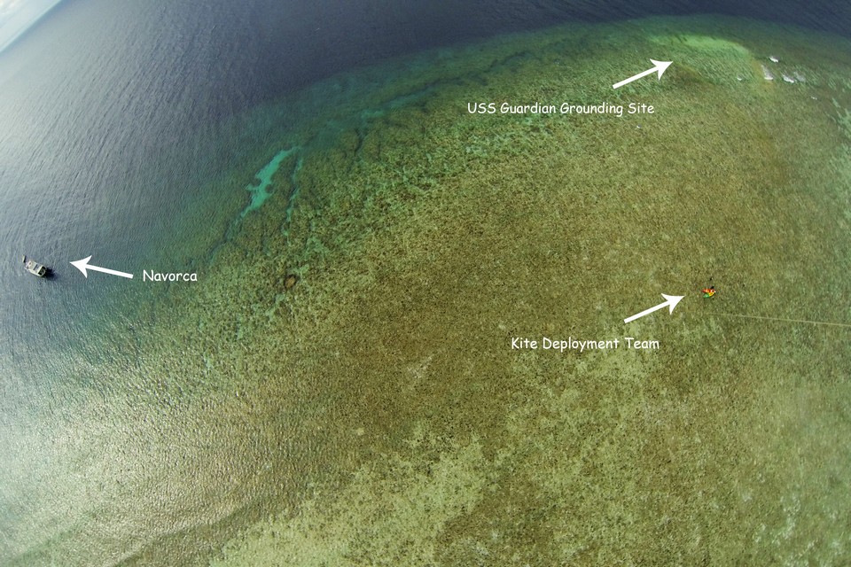
With ground control points and accurate GPS readings, scientists deployed ARRAS in Tubbataha Reef to measure the reef scars caused by the grounding of the USS Guardian and the F/V Min Long Yu earlier in the year.
But why a kite?
There are three ways to get a camera in the air: a balloon, an Unmanned Aerial Vehicle (UAV), and a kite. The ARRAS team tested the balloon and the kite, with the kite winning because of the low cost, ease of transport, and fast deployment. "The balloon is good for no-wind conditions. But when the wind is moderate to strong, the balloon tends to sway. Balloons also need helium, which isn't cheap and readily available. On the other hand, kites are good for moderate to strong winds. It can also still be used in no-wind conditions as long as your vessel is moving to keep the kite in the air. It's also easy to deploy and fold for storage," says Natividad.
Though the project is simple in theory, it becomes complicated during the field work. Kite aerial photos must be perpendicular to the camera and completely clear for ease of georeferencing. The best time to take photos are early in the morning (8-9am) or late afternoon (4-5pm) to minimize glint and at low tide in order to see the bottom more clearly. However, these conditions seldom occur together in the field.
"We may be in an area at the right time but there's no wind. Or there is wind but our timing is off. We need to scout an area during our initial visit so this causes us to miss the no-glint period. We also can't go back to the same area as we have other locations to visit. This is one of the reasons why it would be better for the locals to do this. They know the area and can stay longer", says Natividad.
Since the start of the program, the ARRAS kite team has visited several locations in Philippines, including Iloilo, Cebu, Zambales, Sorsogon, Cagayan, Mati, Tawi-Tawi, Palawan.
The ARRAS project is composed of teams from the Marine Science Institute (headed by Dr. Cesar Villanoy) and the National Institute of Physics (headed by Dr. Maricor Soriano) from the University of the Philippines, De La Salle University-Manila (headed by Dr. Wilfredo Licuanan), and Mapua Institute of Technology (headed by Engr. Roel John Judilla).
Looking out for Philippine coral reefs
The Philippines lies within the Coral Triangle, said to be the center of the center of marine biodiversity. The Philippine coastline stretches 17,460 km, shared among more than 60% of the country's local government units and provinces. Coastal waters measure 266,000 km2 - bigger than the country's land area. Philippine coral reefs cover over 2.5 million hectares, providing ecosystem services including food, protection from storm surges, breeding and feeding ground of endangered species, natural products, and jobs through recreation and tourism. These ecosystem system services have a potential value of 38.7 trillion pesos per year. However, only 5% of Philippine reef areas are considered to be in good condition. Coral reefs are threatened by climate change and local human-caused stresses such as improper coastal development, sedimentation, pollution, overfishing, and destructive fishing practices. (Photos by Darryl Kim Natividad and Leilani Solera) — TJD, GMA News
