
10 areas under Signal No. 3 as Ompong takes aim at Isabela-Cagayan area
Ten areas are now under Signal No. 3 as Typhoon Ompong maintained its strength late Friday morning and continued to threaten the Isabela-Cagayan area.
More areas were placed under Tropical Cyclone Warning System (TCWS) as Ompong kept a steady course towards the Cagayan-Isabela area, according to PAGASA’s 11 a.m. weather bulletin.
PAGASA said areas under Signal No. 3 are:
- Cagayan incl. Babuyan group of Is.
- Apayao
- Abra
- Kalinga
- Mountain Province
- Ifugao
- Nueva Vizcaya
- Quirino
- Northern Aurora
- Isabela
Waves may rise up to 14.0 meters in the open sea and storm surges are possible in coastal areas.
/p>
Meanwhile, areas under Signal No. 2 are:
- Batanes
- Ilocos Norte
- Ilocos Sur
- La Union
- Benguet
- Pangasinan
- Tarlac
- Nueva Ecija
- Southern Aurora
- Northern Zambales
Waves are expected to range from 4.1 to 14.0 meters in the open sea and storm surges are possible in coastal areas.
Areas under Signal No. 1 are:
- Southern Zambales
- Pampanga
- Bulacan
- Bataan
- Rizal
- Metro Manila
- Cavite
- Batangas
- Laguna
- Quezon incl. Polillo Is.
- Northern Occidental Mindoro incl. Lubang Is.
- Northern Oriental Mindoro
- Masbate
- Marinduque
- Camarines Norte
- Camarines Sur
- Catanduanes
- Albay
- Sprsogon
- Burias and Ticao Islands
- Northern Samar
Storm surge
PAGASA said “stormy weather” is expected in areas under Signal No. 2 and 3.
“‘Pag sinabing stormy weather, let’s anticipate the worst case scenario, lalo na sa areas na may Tropical Cyclone Warning Signal 2 at 3,” PAGASA weather specialist Chris Perez said in a press briefing.
It also said Cagayan and Isabela may expect up to six meters of storm surge.
“Fisherfolks and those with small seacrafts are advised not to venture out over the seaboards of areas with TCWS (Tropical cyclone Warning Signal) and the eastern seaboards of Visayas and of Mindanao,” it warned.
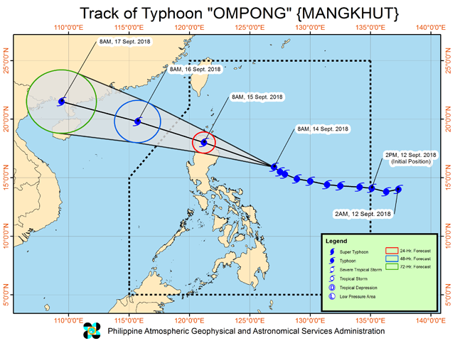
Ompong is forecast to make landfall early on Saturday in the Cayagan- Isabela area and will be the strongest of 15 storms to have hit the country this year.
Medical and emergency response teams were on stand by, heavy equipment mobilized and more than P1.7 billion of relief goods prepared as the typhoon edged toward northern Luzon.
Class suspensions have been announced as early as Wednesday in some areas in anticipation of Ompong, which will leave the Philippine Area of Responsibility on Sunday.
Habagat
Visayas will experience moderate to occasionally heavy rains due to the typhoone-enhanced Southwest Monsoon (Habagat), while scattered light to moderate to at times heavy rains over will prevail over Palawan, Zamboanga Peninsula, Northern Mindanao and Caraga.
“Residents in these areas, especially those living near river channels, in low-lying areas and in mountainous areas, are advised to take appropriate actions against possible flooding and landslides, coordinate with local disaster risk reduction and management offices, and to continue monitoring for updates,” it said
Ompong maintained its strength as it moved northwest at 20 kms per hour. It was last located 540 kms east of Baler, Aurora at 10 a.m. with maximum sustained winds of 205 kms per hour near the center and gustiness of up to 255 kms per hour.
Another severe weather bulletin will be issued at 2 p.m. —with Reuters/Rie Takumi/KBK/VDS, GMA News
