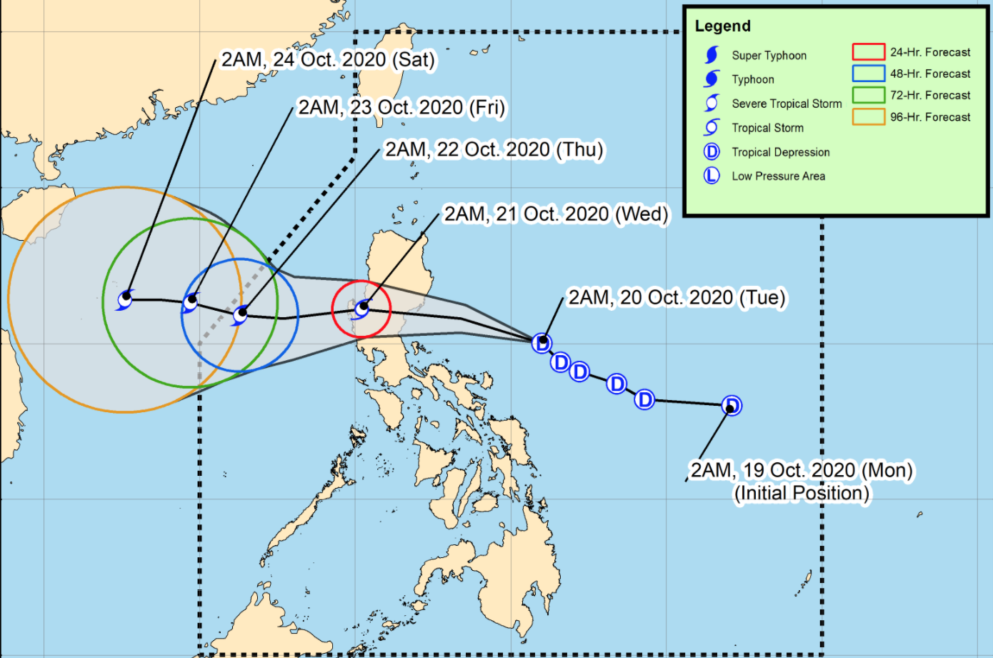
13 areas under Signal No. 2 as Pepito intensifies into tropical storm

Thirteen areas in Luzon were placed under Tropical Cyclone Wind Signal No. 2 as Tropical Depression Pepito intensified into a tropical storm on Tuesday.
In its 11 a.m. bulletin, state weather bureau PAGASA said the following areas are under Signal No. 2:
- La Union
- Ifugao
- Benguet
- Nueva Vizcaya
- Quirino
- Pangasinan
- Nueva Ecija
- Tarlac
- Aurora
- the southern portion of Isabela (Palanan, San Mariano, Benito Soliven, Naguilian, Gamu, Burgos, San Manuel, Aurora,Cabatuan, Luna, Reina Mercedes, Cauayan City, Dinapigue, San Guillermo, Angadanan, Alicia,San Mateo, Ramon, San Isidro, Echague, San Agustin, Jones, Santiago City, Cordon)
- the southern portion of Ilocos Sur (Sugpon, Alilem, Tagudin),
- the northern portion of Zambales (Iba, Palauig, Masinloc, Candelaria, Santa Cruz, Botolan, Cabangan)
- the northern portion of Quezon (General Nakar)
Meanwhile, 12 areas, still in Luzon, were placed under Signal No. 1:
- Abra
- Kalinga
- Mountain Province
- Bulacan
- Pampanga
- Bataan
- Metro Manila
- Rizal
- the northern portion of Camarines Norte (Paracale, Jose Panganiban, Capalonga, Vinzons)
- Catanduanes
- the rest of northern portion of Quezon (Infanta, Real)
- the rest of Zambales
Movement
According to PAGASA, Pepito intensified into a tropical storm at 8 a.m. on Tuesday. It is expected to move west-northwestward and make landfall over the coast of Aurora-Isabela area between 7 p.m. and 11 p.m. on Tuesday.
It will then cross the Luzon landmass and emerge over the West Philippine Sea on Wednesday morning.
PAGASA said Pepito may exit the Philippine Area of Responsibility (PAR) on Thursday morning. It may also intensify further and reach severe tropical storm category by that day.
As of 10 a.m., the center of Tropical Storm "Pepito" was estimated based on all available data at 295 km east of Baler, Aurora, with maximum sustained winds of 65 kph near the center and gustiness of up to 80 kph.
It is moving northwestward at 25 kph.
Effects
Even before it intensified, rains spawned by Pepito have already caused floods in several areas.
In Lopez, Quezon, portions of the Maharlika Highway became flooded on Tuesday. Floodwaters in some barangays reached waist level.
In Cotabato, rivers overflowed in President Roxas and Magpet. Residents evacuated in Pikit and Kabacan. One person died in Makilala after being caught in a mudslide.
Meanwhile, in Baggao, Cagayan, some bridges were flooded and landslides were reported.
In Metro Manila, fishermen pulled their bancas to safer ground.
Rainfall forecasts
Due to Tropical Storm Pepito, moderate to heavy rains are expected over the Bicol Region, MIMAROPA, Quezon, Aurora, Nueva Ecija, Nueva Vizcaya, Quirino, Isabela, mainland Cagayan, Pangasinan, and Benguet.
Light to moderate with at times heavy rains will be experienced over Metro Manila and the rest of Luzon, Western Visayas, Zamboanga Peninsula, and Bangsamoro.
The state weather bureau said flooding (including flashfloods) and rain-induced landslides may occur during heavy or prolonged rainfall especially in areas that are highly or very highly susceptible to these hazards.
High to gale-force winds are expected to be experienced in areas under Tropical Cyclone Wind Signal (TCWS) 1 and 2.
Batanes, Babuyan Islands, and the coastal and/or mountainous areas of mainland Cagayan, Apayao, and Ilocos Norte will experience high to gale-force winds with occasional gusts due to the northeasterly surface wind flow.
PAGASA said gale Warning is in effect over the seaboards of Batanes, Cagayan, and Ilocos Norte and due to rough to very rough seas. Also, the seaboards of areas under TCWS #1 and 2 will also experience rough to very rough seas.
Sea travel will be risky over these areas, especially for those using small seacrafts.
Moderate to rough seas will meanwhile prevail over the western and eastern seaboards of Southern Luzon and the eastern seaboards of Eastern Visayas, Caraga, and Davao Region
Small seacrafts are thus advised to take precautionary measures when venturing out to sea, and inexperienced mariners should avoid navigating in the said conditions.
Aside from Pepito, a tropical depression outside the PAR was estimated at 10 a.m. based on all available data at 1,735 km east-northeast of Extreme Northern Luzon with maximum sustained winds of 45 kph and gustiness of up to 55 kph.
The tropical depression is moving north-northwestward at 15 kph, but it is less likely to enter the PAR. —KBK, GMA News


