
Fabian further intensifies; southwest monsoon to bring rains in parts of the country
Typhoon Fabian further intensified as it moved slowly westward, PAGASA said Wednesday.
In its 11 a.m. update, PAGASA said Fabian is unlikely to directly bring heavy rainfall in the country throughout the forecast period, and no Tropical Cyclone Wind Signal was issued.
However, the southwest monsoon enhanced by Fabian and Tropical Storm Cempaka is expected to bring monsoon rains over Ilocos Region, Cordillera Administrative Region, Batanes, Babuyan Islands, Zambales, Bataan, Tarlac, Pampanga, Bulacan, Metro Manila, Cavite, Batangas, Occidental Mindoro, and the northern portion of Palawan (including Calamian and Kalayaan Islands) in the next 24 hours.
Several areas in Metro Manila were flooded Wednesday morning amid the incessant rain brought by the southwest monsoon.
PAGASA said the hoisting of Tropical Cyclone Wind Signal no. 1 over Batanes and Babuyan Islands remains a possibility due to the uncertainty in the later portion of the track forecast of Fabian.
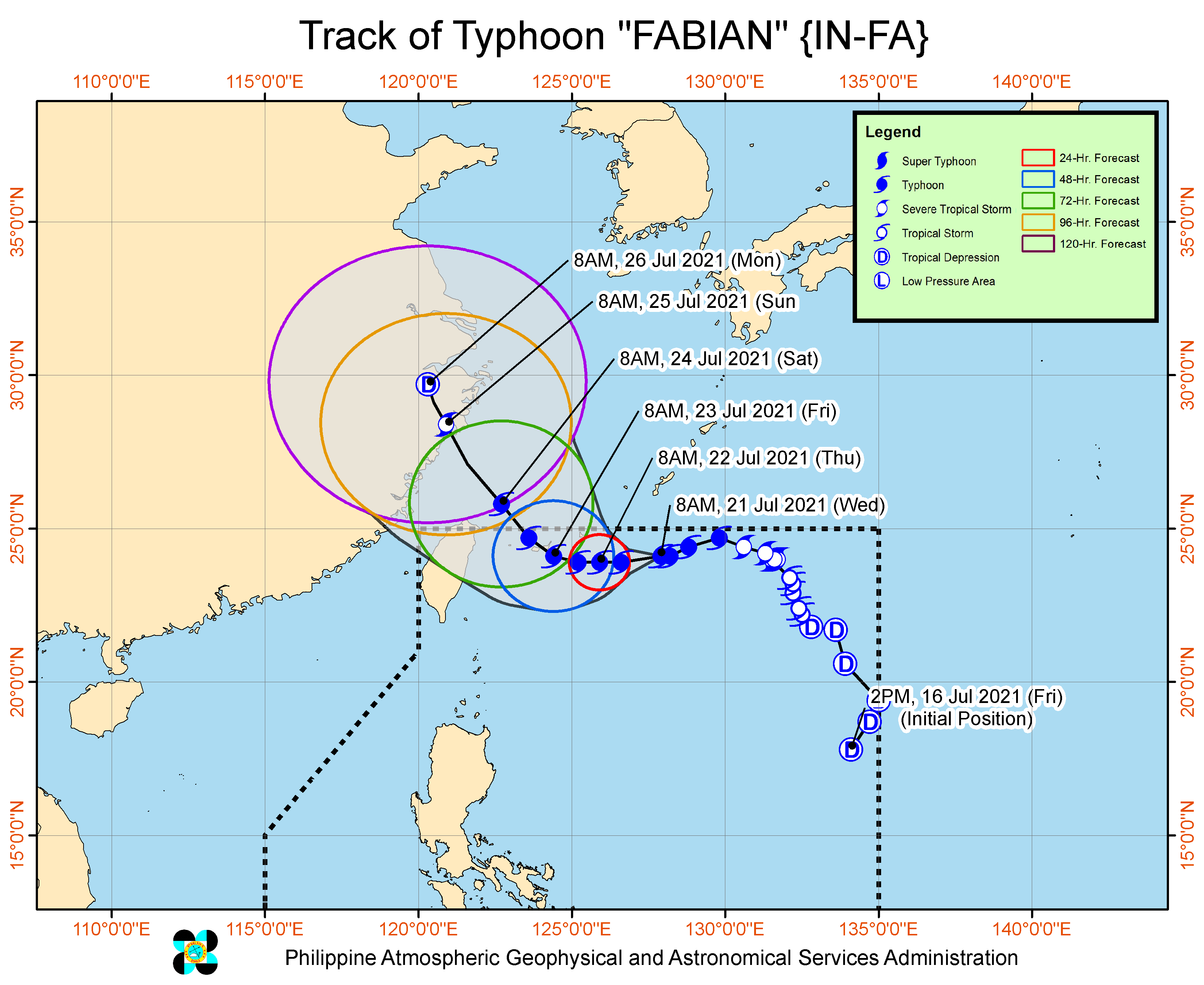
As of 10 a.m., the center of the eye of Typhoon Fabian was located at 705 km east-northeast of Itbayat, Batanes.
It has maximum sustained winds of 150 km/h near the center, gustiness of up to 185 km/h, and central pressure of 960 hPa.
It is moving westward slowly, with strong winds or higher extend outwards up to 650 km from the center.
Rough to very rough seas are expected over the seaboards of Batanes and Babuyan Islands, and the western seaboard of Palawan (including Kalayaan and Calamian Islands) and Occidental Mindoro (including Lubang Islands).
Moderate to rough seas, meanwhile, will prevail over the eastern and the rest of the northern and western seaboards of Luzon.
The state weather bureau said Fabian will track generally westward until Thursday evening, west northwestward by Friday morning, then will begin to turn northwestward by Friday evening.
Based on the forecast track, Fabian will pass close or make landfall in the vicinity of Yaeyama, Miyako, and Senkaku Islands of the Ryukyu Archipelago, Japan, on Friday before exiting the Philippine area of responsibility on Saturday morning.
PAGASA added that Fabian is forecast to further intensify and reach its peak intensity of 165 km/h on Thursday, but gradual weakening may occur beginning on Saturday due to frictional effects of the rugged terrain of Taiwan.
The landfall over mainland China will result in the rapid weakening of Fabian on Sunday, PAGASA said.—AOL, GMA News
