
Amang now in vicinity of Camarines Sur, Signal No. 1 over 11 areas
The center of Amang continues to move westward and is now over Northeastern Camarines Sur early Wednesday morning, PAGASA reported in its latest Cyclone Bulletin.
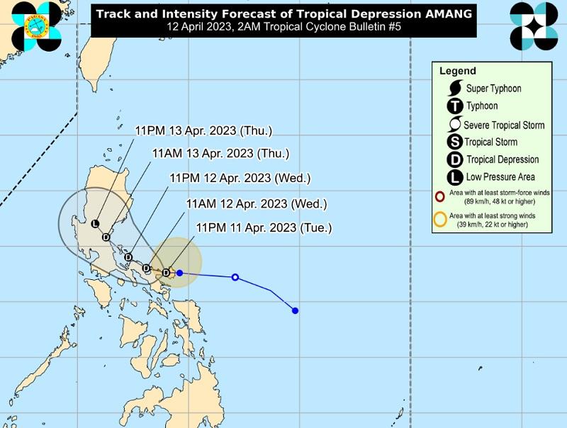
The center of Tropical Depression Amang was estimated to be in the vicinity of Presentacion, Camarines Sur packing maximum sustained winds of 45 kilometers per hour near the center, gustiness of up to 60 km/h, and central pressure of 1006 hPa.
Amang is moving Westward at 20 km/h with strong winds extend outwards up to 200 km from the center.
Tropical Cyclone Wind Signal (TCWS) No. is hoisted over the following areas:
Luzon
- Catanduanes
- Sorsogon
- Albay
- Camarines Sur
- Camarines Norte
- Ticao Island
- Burias Island
- the eastern portion of Laguna (San Pablo City, Rizal, Nagcarlan, Pila, Liliw, Magdalena, Majayjay, Luisiana, Cavinti, Pagsanjan, Santa Cruz, Lumban, Kalayaan, Paete, Pakil, Pangil, Siniloan, Famy, Santa Maria, Mabitac)
- Aurora
- Quezon
- the eastern portion of Rizal (Tanay, Pililla, Jala-Jala)
Residents in these areas may expect strong winds with potential impacts of minimal to minor threat to life and property.
Hazards affecting land areas
The forecast accumulated rainfall from this early morning until tonight, with 50-100 mm in Camarines Provinces and the southeastern portion of Quezon.
From early morning until Friday evening, 50-100 mm in Camarines Provinces, the northern and southeastern portions of Quezon, and the eastern portions of Rizal and Laguna.
The weather bureau reports that isolated flashfloods and rain-induced landslides may occur, especially in areas that are highly or very highly susceptible to these hazards.
"Areas under Wind Signal No. 1 may experience strong winds (strong breeze to near gale strength) associated with the tropical depression which may cause minimal to minor impacts to life and property," PAGASA added.
Hazards affecting coastal waters
A marine gale warning remains in effect over Catanduanes, the eastern coasts of Albay and Sorsogon, and the northern and eastern coasts of Northern Samar and Eastern Samar.
Moderate to rough seas over the eastern seaboards of Central Luzon, Southern Luzon, and Eastern Visayas that are not under any gale warning.
"Mariners of small seacrafts are advised to take precautionary measures when venturing out to sea and, if possible, avoid navigating in these conditions."
Track and Intensity Outlook
Amang is forecast to move generally westward or west northwestward in the next 12 hours, which will bring its center over the Camarines Provinces, before turning more northwestward towards the waters east of Quezon, with the possibility of passing near or over the Polillo Islands.
Landfall over Aurora or mainland Quezon may take place on Thursday and continue moving westward towards the Bicol Peninsula and mainland Quezon.
Amang is expected to weaken by Thursday or possibly earlier due to the combined effects of land interaction, dry air intrusion, and increasing vertical wind shear. -- BAP, GMA Integrated News
