
Signal No. 1 in 15 areas as Betty weakens slightly
Typhoon Betty (international name: Mawar) slightly weakened on Sunday evening but more areas have been placed under Tropical Cyclone Wind Signal 1 (TCWS), state weather bureau PAGASA reported.
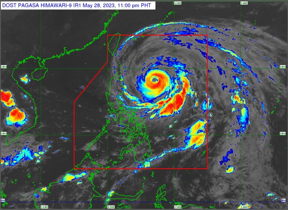
In its Tropical Cyclone Bulletin 8 published past 11 p.m. on Sunday, PAGASA said the center of the eye of the typhoon was estimated 570 kilometers east of Tuguegarao City, Cagayan, moving northwestward at 10 kilometers per hour (kph).
It was reported to have maximum sustained winds of 155 kph, near the center and gustiness of up to 190 kph, slower than the earlier reported winds of 165 kph and gustiness of up to 205 kph as of 5 p.m.
The following areas are under Signal No. 1, indicating that winds of 39 kph to 61 kph or intermittent rains are expected within 36 hours:
- Batanes,
- Cagayan including Babuyan Islands,
- Isabela,
- Quirino,
- the northeastern portion of Nueva Vizcaya (Kasibu, Quezon, Solano, Bagabag, Diadi, Villaverde, Bayombong, Ambaguio),
- Apayao,
- Abra,
- Kalinga,
- Mountain Province,
- Ifugao,
- Ilocos Norte,
- the northern and central portions of Aurora (Dilasag, Casiguran, Dinalungan, Dipaculao, Baler), Polillo Islands,
- the northern portion of Catanduanes (Caramoran, Viga, Gigmoto, Panganiban, Bagamanoc, Pandan),
- the northeastern portion of Camarines Sur (Caramoan, Garchitorena, Lagonoy, Tinambac, Siruma), and
- the northern portion of Camarines Norte (Vinzons, Paracale, Jose Panganiban, Capalonga, Talisay, Daet, Mercedes, Basud)
PAGASA said Typhoon Betty has started to enhance the Southwest Monsoon or Habagat, with occasional gusts possible in the next 24 hours over localities in the eastern portion of central Luzon, eastern and southern portions of Southern Luzon that are not under any Wind Signal, and most of Visayas.
“On the track forecast, Betty will move generally northwestward slowly tonight through tomorrow and may become slow-moving or almost stationary by Tuesday or Wednesday while over the waters east of Batanes,” it said.
Betty is then expected to turn north northeastward and gradually accelerate towards the waters east of Taiwan and exit the Philippine area of responsibility (PAR) on Friday evening.
A number of flights on May 28, flights for May 29, and sea trips have been canceled due to inclement weather conditions brought about by Typhoon Betty, which entered PAR early Saturday morning.
Monday classes in some areas have also been canceled. — Jon Viktor D. Cabuenas/BM, GMA Integrated News
