


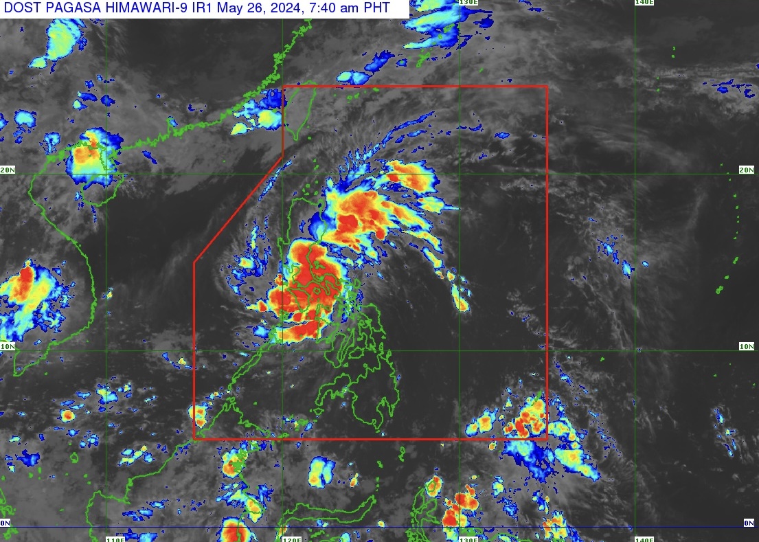
Tropical Storm “Aghon” (#AghonPH) maintains its strength and is seen over Dolores in the Province of Quezon.
State weather bureau PAGASA issued a weather bulletin on May 26, 2024 on the center of #AghonPH estimated based on all available data including those from Tagaytay Doppler Weather Radar in the vicinity of Dolores, Quezon.
The storm moves northwestward at 15 km/h, packing maximum sustained winds of 65 km/h near the center and gustiness of up to 110 km/h.
Tropical Cyclone Wind Signal Number 2 (gale-force winds) is raised over the following areas in Luzon:
The northern and central portions of Quezon (Alabat, Perez, Quezon, Gumaca, Lopez, Macalelon, General Luna, Unisan, Pitogo, Plaridel, Agdangan, Padre Burgos, Atimonan, Mauban, Real, General Nakar, Infanta, Sampaloc, Pagbilao, Calauag, Lucban, City of Tayabas, Lucena City, Tiaong, Candelaria, Sariaya, Dolores, San Antonio) including Polillo Islands, Laguna, the eastern portion of Rizal (Jala-Jala, Pililla, Tanay), and the eastern portion of Batangas (City of Tanauan, San Jose, Lipa City, Mataasnakahoy, Balete, Malvar, Santo Tomas, Cuenca, San Pascual, Batangas City, Ibaan, Padre Garcia, Rosario, San Juan, Taysan, Lobo);
TCWS Number 1 (strong winds) is raised over the following areas in Luzon:
The southeastern portion of Isabela (Palanan, Dinapigue), the southern portion of Quirino (Maddela, Nagtipunan), the southern portion of Nueva Vizcaya (Alfonso Castaneda), the eastern and southern portions of Nueva Ecija (General Tinio, Gabaldon, Bongabon, Pantabangan, Rizal, General Mamerto Natividad, Laur, Palayan City, Peñaranda, San Leonardo, City of Gapan, Cabanatuan City, Santa Rosa, San Isidro, Cabiao, San Antonio, Jaen), Aurora, the eastern portion of Pampanga (Candaba, San Luis, San Simon, Apalit, Santa Ana, Arayat), Bulacan, Metro Manila, the rest of Quezon, the rest of Rizal, Cavite, the rest of Batangas, the northern portion of Oriental Mindoro (Pinamalayan, Pola, Naujan, Victoria, Socorro, City of Calapan, Bansud, Gloria, Baco, San Teodoro, Puerto Galera, Bongabong, Roxas), Marinduque, Romblon, Camarines Norte, Camarines Sur, the northern portion of Albay (Tiwi, Polangui, Malinao, Libon, Oas, City of Ligao), and Burias Island.
HEAVY RAINFALL OUTLOOK
Forecast accumulated rainfall: May 26, 2024
• > 200 mm: Quezon
• 100-200 mm: Aurora, the eastern portion of Bulacan, Rizal, Laguna, Metro Manila, and Camarines Norte
• 50-100 mm: The eastern portion of Isabela, Nueva Ecija, the rest of Bulacan, the eastern portion of Pampanga, the rest of CALABARZON, Oriental Mindoro, Occidental Mindoro, Romblon, Burias Island, the western portion of Camarines Sur, Cuyo Islands, Aklan, and Antique.
Forecast accumulated rainfall: May 27, 2024
• 50-100 mm: The eastern portion of Isabela, the northern portion of Aurora, and Polillo Islands.
Forecast rainfall are generally higher in elevated or mountainous areas. Under these conditions, flooding and rain-induced landslides are likely especially in areas that are highly or very highly susceptible to these hazards as identified in hazard maps and in localities that experienced considerable amounts of rainfall for the past several days
COASTAL INUNDATION
Within the next 24 hours, there is a minimal to moderate risk of storm surge over the exposed and low-lying coastal areas of Cagayan, Isabela, Aurora, Central Luzon, Metro Manila, CALABARZON, Mindoro Provinces, Marinduque, Romblon, Camarines Norte, Camarines Sur, Albay (west coast), Burias Island, mainland Masbate (northwest coast), and Aklan.
HAZARDS AFFECTING COASTAL WATERS
A Gale Warning is hoisted over the coastal waters of Marinduque and Quezon, the southern coastal waters of Batangas, and the northern coastal waters of Camarines Norte. Sea travel is risky for small seacraft, including all motorbancas of any type of tonnage.
Outside the Gale Warning areas, #AghonPH will bring moderate to rough seas (1.5 to 3.5 m) over the coastal waters along the northern and eastern seaboards of Luzon and the seaboard of Bicol Region.
Mariners of motor bancas and similarly-sized vessels are advised to take precautionary measures while venturing out to sea and, if possible, avoid navigating in these conditions, especially if inexperienced or operating ill-equipped vessels.