


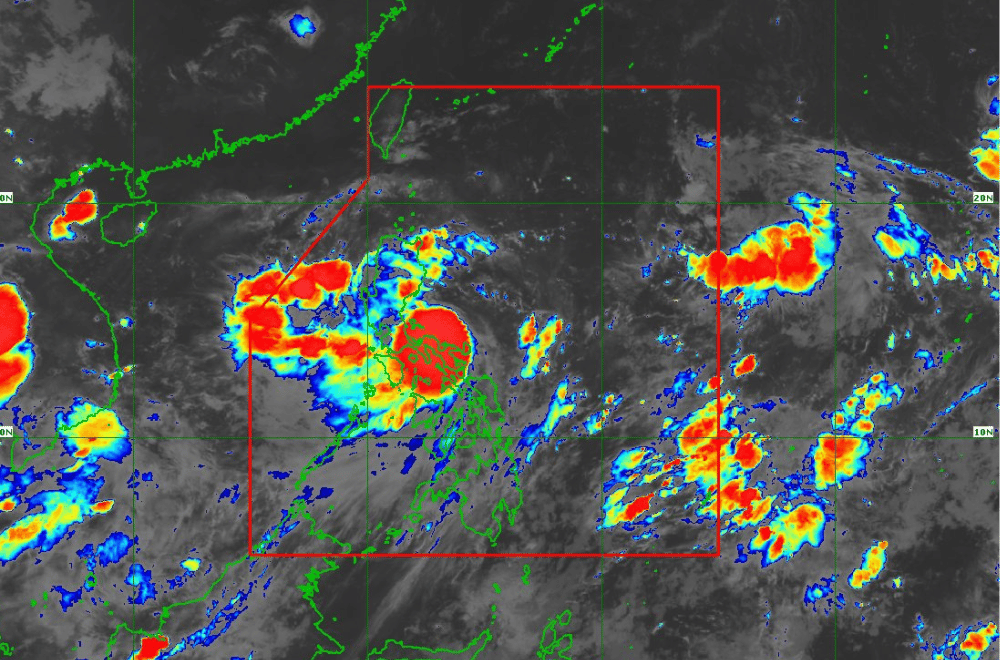
Tropical Storm #EntengPH has maintained its strength while moving northwestward over the coastal waters of Vinzons, Camarines Norte, according to the Philippine Atmospheric, Geophysical and Astronomical Services Administration (PAGASA).
As of 2:00 a.m. of September 2, 2024, the center of #EntengPH was located northeast of Vinzons, Camarines Norte.
The storm is moving at a speed of 30 km/h in a northwestward direction.
The storm currently has maximum sustained winds of 65 km/h near its center, with gustiness reaching up to 80 km/h.
Tropical Cyclone Wind Signal No. 2 has been raised over:
- The northeastern portion of Camarines Norte (Vinzons)
- The northeastern portion of Camarines Sur (Garchitorena, Caramoan, Presentacion, San Jose, Lagonoy, Tinambac, Siruma)
- Catanduanes
- The eastern portion of Cagayan (Pe, Gonzaga, Santa Teresita, Buguey, Lal-Lo, Gattaran, Baggao, Santa Ana)
- The eastern portion of Isabela (Palanan, Divilacan, Dinapigue, San Mariano, Maconacon, San Pablo, Cabagan, Ilagan City, Tumauini)
Tropical Cyclone Wind Signal No. 1 has been raised over:
- The southern portion of Batanes (Sabtang, Ivana, Uyugan, Mahatao, Basco)
- Apayao
- The eastern portion of Kalinga (Tanudan, City of Tabuk, Balbalan, Pinukpuk, Rizal, Lubuagan)
- The eastern portion of Mountain Province (Barlig, Natonin, Paracelis)
- The eastern portion of Ifugao (Banaue, Hingyon, Lagawe, Lamut, Mayoyao, Alfonso Lista, Aguinaldo)
- The rest of Cagayan, including Babuyan Islands
- The rest of Isabela
- Quirino
- The eastern portion of Nueva Vizcaya (Alfonso Castaneda, Kasibu, Dupax del Norte, Bagabag, Diadi, Quezon, Villaverde, Solano)
- Aurora
- The northern and southern portions of Quezon (Tagkawayan, Guinayangan, Buenavista, San Narciso, Mulanay, San Andres, San Francisco, Lopez, Calauag, Catanauan, Gumaca, Macalelon, General Luna, Quezon, Alabat, Perez, General Nakar, Infanta, Real, Mauban, Unisan, Pitogo, Padre Burgos, Atimonan, Agdangan, Plaridel), including Polillo Islands
- The rest of Camarines Norte, the rest of Camarines Sur, Albay, Sorsogon, and the northern portion of Masbate (City of Masbate, Aroroy, Baleno, Mobo), including Ticao and Burias Islands
- Northern Samar
Heavy Rainfall Outlook:
PAGASA has warned of heavy rainfall from "Enteng" and the enhanced Southwest Monsoon. Areas including Camarines Norte, Camarines Sur, Albay, Polillo Island, and the southern portion of mainland Quezon may experience over 200 mm of rainfall from tonight until tomorrow evening. Other areas such as Aurora, Catanduanes, Masbate, and Sorsogon are expected to receive 100-200 mm of rain.
The heavy rainfall could cause flooding and landslides, especially in elevated or mountainous regions. Residents in these areas are advised to take precautionary measures.
Severe Winds:
Strong winds are expected in areas under TCWS No. 1 and 2, with possible stronger gusts in coastal and upland areas. The enhanced Southwest Monsoon will bring strong to gale-force gusts to regions including Ilocos, Zambales, Bataan, Aurora, Metro Manila, and parts of Visayas and MIMAROPA.
Hazards Affecting Coastal Waters:
Gale Warnings are in effect for the coastal waters of Catanduanes, Camarines Norte, and parts of Bicol, with sea travel deemed risky, especially for small vessels. Mariners are advised to avoid navigating in these conditions.
Track and Intensity Outlook:
#EntengPH is forecast to continue its northwestward movement and may possibly make landfall in Northern Luzon or the Babuyan Islands by tomorrow evening. The storm is expected to gradually intensify into a severe tropical storm by Wednesday and could potentially reach typhoon category by Thursday or Friday as it moves over the Luzon Strait.
PAGASA advises the public to stay updated on further advisories and take necessary precautions as #EntengPH progresses.
