


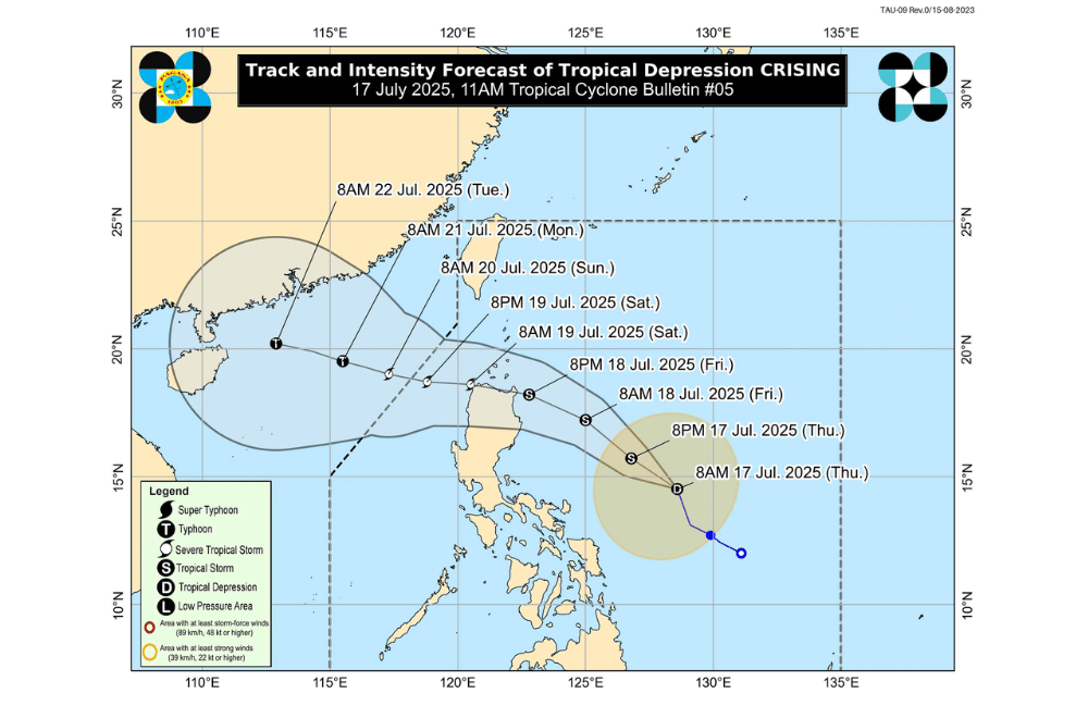
Tropical Depression #CrisingPH has maintained its strength and turned Northwestward over the waters East of Catanduanes and may make landfall in Cagayan by evening on July 18, 2025 or early morning on July 19, according to the Philippine Atmospheric, Geophysical and Astronomical Services Administration (PAGASA).
As of 11 a.m. on July 17, 2025, the eye of Tropical Depression #CrisingPH was located approximately 520 km East Northeast of Juban, Sorsogon or 470 km East Northeast of Virac, Catanduanes (14.7°N, 128.4°E).
It is moving North Northwestward at a speed of 25 km/h.
#CrisingPH currently has a maximum sustained winds of 55 km/h near the center, gustiness of up to 70 km/h, and central pressure of 1000 hPa.
It is expected to intensify into a tropical storm within the day and may strengthen further into a severe tropical storm by evening on July 18, 2025, before crossing Northern Luzon.
Tropical Cyclone Wind Signal No. 1 has been raised over:
- Southern portion of Batanes (Sabtang, Ivana, Uyugan, Mahatao, Basco)
- Cagayan including Babuyan Islands
- Isabela
- Quirino
- Northeastern portion of Nueva Vizcaya (Kasibu, Quezon, Bagabag, Diadi, Bayombong, Solano, Ambaguio, Villaverde)
- Northern portion of Aurora (Dilasag, Casiguran, Dinalungan, Dipaculao)
- Apayao
- Abra
- Kalinga
- Mountain Province
- Ifugao
- Ilocos Norte
- Northern portion of Ilocos Sur (City of Vigan, Santa, Caoayan, Bantay, Nagbukel, Narvacan, Cabugao, San Juan, Sinait, Magsingal, San Ildefonso, Santo Domingo, San Vicente, Santa Catalina)
- Northern and eastern portions of Catanduanes (Pandan, Bagamanoc, Panganiban, Viga, Gigmoto)
SEA CONDITIONS AND STORM SURGE
A minimal to moderate risk of storm surge is expected over low-lying coastal areas in Cagayan, including the Babuyan Islands, and in Isabela.
Waves could reach up to 2 meters in the next 48 hours, posing a threat to lives and property. Meanwhile, sea travel may be risky in several coastal areas due to rough to moderate sea conditions:
Rough seas (Up to 2.5 m):
- The western seaboard of Palawan; the northern and eastern seaboards of Catanduanes; the northern and western seaboards of Zamboanga del Norte and Camiguin; the southern seaboards of Negros Oriental, Siquijor, Bohol and Southern Leyte; the eastern seaboards of Davao Region; and the western seaboards of Surigao del Norte and Dinagat Islands.
Moderate seas (up to 2.0 m):
- The northwestern seaboard of Occidental Mindoro; the northwestern seaboard of Masbate; the southwestern seaboards of Antique and Negros Occidental; the eastern seaboards of Northern and Eastern Samar.
Motorbancas and similar vessels are advised to take precaution or avoid going out to sea under these conditions.
RAINFALL FORECAST
On Friday (July 19), moderate to heavy rains may affect Metro Manila, Central Luzon, CALABARZON, MIMAROPA, Bicol Region, Visayas, Zamboanga Peninsula, Misamis Occidental, Lanao del Norte, Camiguin, Dinagat Islands, Davao Occidental, and Davao Oriental. PAGASA urged residents in high-risk areas to follow evacuation orders and other instructions from local authorities.
For local weather warnings and rainfall advisories, the public is advised to monitor updates from their nearest PAGASA Regional Services Division.
