


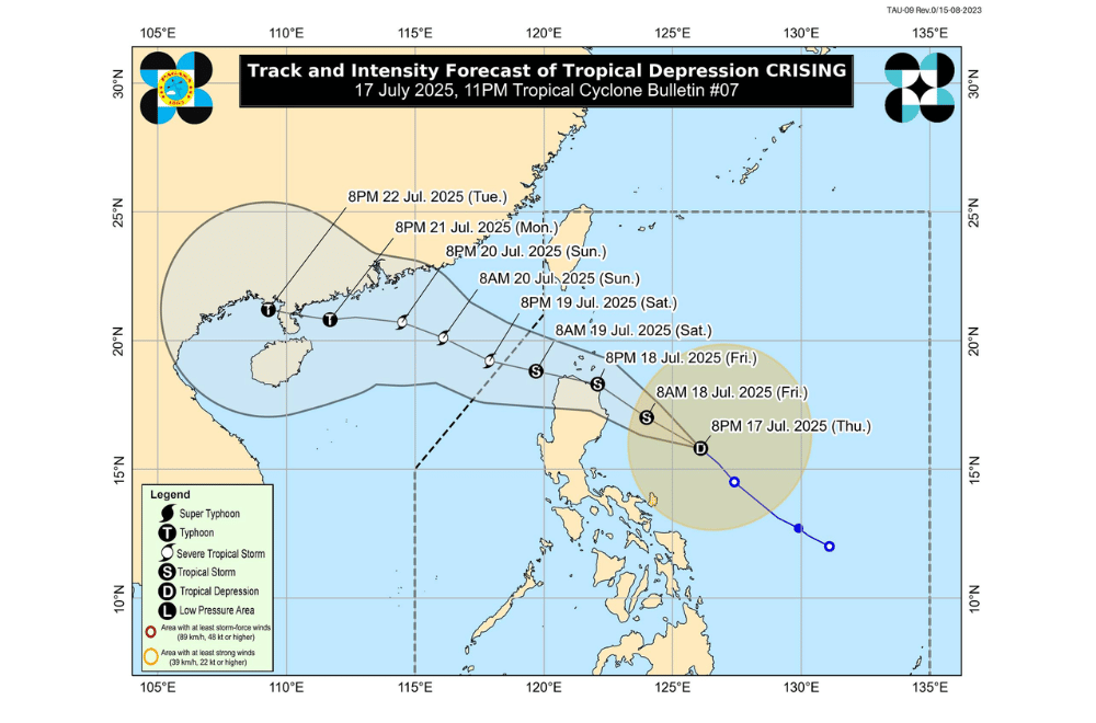
Tropical Depression #CrisingPH has maintained its strength as it moves Northwestward toward Northern Luzon and may make landfall in Cagayan or Babuyan Islands by the afternoon or evening of July 18, 2025, according to the Philippine Atmospheric, Geophysical and Astronomical Services Administration (PAGASA).
As of 10 p.m. on July 17, 2025, the center of Tropical Depression #CrisingPH was located approximately 460 km East of Baler, Aurora (16.0°N, 125.9°E).
It is moving Northwestward at a speed of 15 km/h.
#CrisingPH currently has maximum sustained winds of 55 km/h near the center, gustiness of up to 70 km/h, and a central pressure of 1000 hPa.
It is expected to intensify into a tropical storm by early Friday and may reach severe tropical storm category by Saturday, July 19, 2025, before exiting the Philippine Area of Responsibility.
Tropical Cyclone Wind Signal No. 1 has been raised over:
- Batanes
- Cagayan including Babuyan Islands
- Isabela
- Apayao
- Abra
- Ilocos Norte
- Ilocos Sur
- Kalinga
- Mountain Province
- Ifugao
- Benguet
- La Union
- Quirino
- Northern portion of Aurora (Dilasag, Casiguran, Dinalungan, Dipaculao, Baler, Maria Aurora)
- Nueva Vizcaya
- Northern portion of Pangasinan (San Nicolas, Natividad, San Quintin, San Manuel, Tayug, Sison, San Fabian, Pozorrubio, Laoac, Binalonan, San Jacinto, Manaoag, Mangaldan, Dagupan City, Binmaley, Lingayen, Labrador, Sual, City of Alaminos, Bolinao, Anda, Bani, Agno, Burgos, Mabini, Dasol, Calasiao, Santa Barbara, Mapandan, Bugallon)
- Northern portion of Nueva Ecija (Carranglan, Pantabangan)
- Polillo Islands
- Camarines Norte
- Northeastern portion of Camarines Sur (Caramoan, Garchitorena, Lagonoy, San Jose, Presentacion, Tinambac, Siruma, Goa)
- Catanduanes
SEA CONDITIONS AND STORM SURGE
A minimal to moderate risk of storm surge is expected over low-lying coastal areas in Cagayan including the Babuyan Islands, Isabela, Ilocos Norte, and Ilocos Sur.
Waves may reach up to 2 meters in the next 48 hours, posing risks to lives and property.
Sea travel remains risky in several coastal areas due to rough to very rough sea conditions:
Very rough seas (up to 4.5 m):
- Northern and eastern seaboards of Batanes
Rough seas (up to 3.5 m):
- Eastern seaboard of Cagayan including Babuyan Islands
- Remaining seaboards of Batanes
Rough seas (up to 3.0 m):
- Northern seaboard of Cagayan
- Eastern seaboards of Isabela and northern Aurora
- Western seaboard of Palawan
- Southern seaboards of Antique, Iloilo, and Guimaras
- Western and southern seaboards of Negros Occidental
Moderate seas (up to 2.5 m):
- Remaining seaboards of Palawan
- Northern and western seaboards of Zamboanga del Norte and Camiguin
- Southern seaboards of Siquijor, Bohol, and Southern Leyte
- Eastern seaboards of Davao Region
- Seaboards of Surigao del Norte and Dinagat Islands
Moderate seas (up to 2.0 m):
- Western seaboard of Occidental Mindoro and Romblon
- Northwestern seaboard of Masbate
- Remaining seaboards of Aurora and Antique
- Northern and eastern seaboards of Polillo Islands and Catanduanes
- Northern seaboards of Camarines Norte and Camarines Sur
- Eastern seaboards of Northern and Eastern Samar
Motorbancas and similar-sized vessels are advised to take precaution or avoid sailing under these conditions.
RAINFALL FORECAST
On Friday (July 18), moderate to heavy rains may affect Metro Manila, Central Luzon, CALABARZON, Bicol Region, MIMAROPA, Visayas, Zamboanga Peninsula, Basilan, Sulu, Tawi-Tawi, Misamis Occidental, Lanao del Norte, Camiguin, Dinagat Islands, Davao Occidental, and Davao Oriental.
Residents in high-risk areas are urged to follow evacuation orders and safety instructions from local authorities.
For local weather warnings and rainfall advisories, the public is advised to monitor updates from their nearest PAGASA Regional Services Division.
CLASS SUSPENSIONS
Meanwhile, several areas have announced class suspensions for Friday, July 18, 2025 due to the effects of Tropical Depression #CrisingPH.
See link to list here.
