


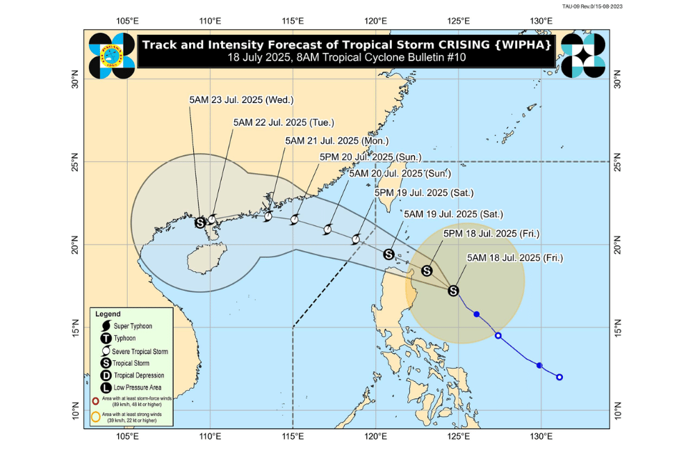
Tropical Storm #CrisingPH has maintained its strength and continues to move Northwestward toward mainland Cagayan and the Babuyan Islands, according to the Philippine Atmospheric, Geophysical and Astronomical Services Administration (PAGASA).
As of 7 a.m. on July 18, 2025, the center of Tropical Storm #CrisingPH was located approximately 250 km East of Tuguegarao City, Cagayan (17.5°N, 124.1°E).It is moving Northwestward at a speed of 15 km/h.
#CrisingPH currently has a maximum sustained winds of 65 km/h near the center, gustiness of up to 80 km/h, and central pressure of 996 hPa.
It may make landfall over mainland Cagayan or Babuyan Islands later this afternoon or evening and is forecast to cross over Extreme Northern Luzon before exiting the Philippine Area of Responsibility by afternoon on Saturday, July 19, 2025. It is expected to strengthen into a Severe Tropical Storm by the same day.
Tropical Cyclone Wind Signal No. 2 has been raised over:
- Batanes,
- Cagayan including Babuyan Islands
- Northern and eastern portions of Isabela (Palanan, Ilagan City, Divilacan, Delfin Albano, Quezon, Tumauini, Maconacon, Santa Maria, Cabagan, San Pablo, Santo Tomas, San Mariano, Dinapigue)
- Apayao
- Northern portion of Kalinga (City of Tabuk, Balbalan, Pinukpuk, Rizal)
- the northern portion of Abra (Malibcong, Lacub, Lagangilang, Licuan-Baay, Danglas, Lagayan, San Juan, Tineg, La Paz, Dolores)
- Ilocos Norte
- Northern portion of Ilocos Sur (Cabugao, Sinait)
Tropical Cyclone Wind Signal No. 1 is in effect over:
- Rest of Isabela
- Quirino
- Nueva Vizcaya
- Rest of Kalinga
- Mountain Province
- Ifugao
- Rest of Abra
- Benguet
- Rest of Ilocos Sur
- La Union
- Northern portion of Pangasinan (San Nicolas, Natividad, San Quintin, San Manuel, Tayug, Sison, San Fabian, Pozorrubio, Laoac, Binalonan, San Jacinto, Manaoag, Mangaldan, Dagupan City, Binmaley, Lingayen, Labrador, Sual, City of Alaminos, Bolinao, Anda, Bani, Agno, Burgos, Mabini, Dasol, Calasiao, Santa Barbara, Mapandan, Bugallon)
- Northern portion of Aurora (Dilasag, Casiguran, Dinalungan, Dipaculao, Baler, Maria Aurora)
- Northeastern portion of Nueva Ecija (Carranglan, Pantabangan)
SEA CONDITIONS AND STORM SURGE
A minimal to moderate risk of storm surge is expected over low-lying coastal areas of Batanes, Cagayan including Babuyan Islands, Isabela, Ilocos Norte, and Ilocos Sur.Wave heights may reach up to 2 meters within 24 hours, posing risks to lives and property.
Gale Warning is up over the northern seaboard of Northern Luzon. Rough to very rough seas may affect several areas:
Very rough seas (up to 5.0 m):
- Seaboards of Batanes
Rough to very rough seas (up to 4.0 m):
- Northern seaboards of Ilocos Norte and Cagayan including Babuyan Islands
Rough seas (up to 3.5 m):
- Northeastern seaboard of Cagayan
- Eastern seaboard of Isabela
- Western seaboard of Ilocos Norte and Palawan
- Southern seaboard of Iloilo
- Western and southern seaboards of Negros Occidental and Guimaras
Moderate to rough seas (2.0–3.0 m):
- Seaboards of Antique, Occidental Mindoro including Lubang Islands, Negros Oriental, Zamboanga Peninsula, Davao Oriental, Palawan, Masbate, and other nearby provinces
Motorbancas and small vessels are advised not to venture out to sea, especially if ill-equipped or manned by inexperienced crew.
RAINFALL FORECAST
The Southwest Monsoon enhanced by #CrisingPH will bring strong to gale-force gusts and rains to several areas.
On Friday (July 18):
- Batangas, Quezon, Bicol Region, MIMAROPA, Visayas, Zamboanga del Norte, Camiguin, Misamis Oriental, Surigao del Norte, Dinagat Islands, Davao Occidental, Davao Oriental, Sarangani
On Saturday (July 19):
- Metro Manila, Central Luzon, CALABARZON, Bicol Region, MIMAROPA, Visayas, Zamboanga Peninsula, Basilan, Sulu, Tawi-Tawi, Misamis Occidental, Lanao del Norte, Camiguin, Surigao del Norte, Dinagat Islands, Davao Occidental, Davao Oriental
On Sunday (July 20):
- Metro Manila, Ilocos Region, Central Luzon, CALABARZON, MIMAROPA, Bicol Region, Western Visayas, Northern Samar PAGASA reminded residents in hazard-prone areas to follow evacuation orders and updates from local officials.
For the latest weather advisories, the public is advised to monitor bulletins from PAGASA and its Regional Services Divisions.
