


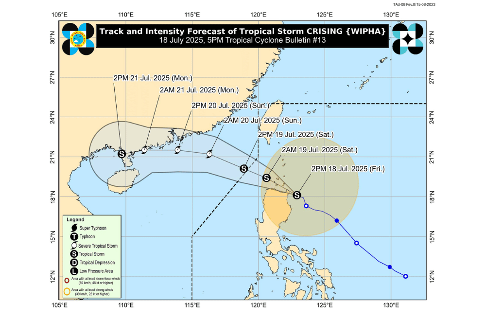
Tropical Storm #CrisingPH continues to approach Northern Cagayan, with stormy conditions imminent over Northern Luzon, according to the Philippine Atmospheric, Geophysical and Astronomical Services Administration (PAGASA).
As of 5 p.m. on July 18, 2025, the center of Tropical Storm #CrisingPH was located approximately 135 km East of Tuguegarao City, Cagayan (18.3°N, 122.9°E).
It is moving West Northwestward at a speed of 20 km/h.
#CrisingPH currently has a maximum sustained winds of 75 km/h near the center, gustiness of up to 105 km/h, and central pressure of 990 hPa.
It may make landfall over mainland Cagayan or Babuyan Islands later this evening and is forecast to cross over Extreme Northern Luzon before exiting the Philippine Area of Responsibility by afternoon on Saturday, July 19, 2025. It is expected to strengthen into a Severe Tropical Storm by the same day.
Tropical Cyclone Wind Signal No. 2 has been raised over:
- Batanes
- Cagayan including Babuyan Islands
- Isabela
- Apayao
- Kalinga
- Northern and central portions of Abra (Manabo, Pidigan, San Juan, Tayum, Langiden, Boliney, Sallapadan, Bucloc, Lagangilang, Danglas, La Paz, Licuan-Baay, Tineg, Malibcong, Peñarrubia, San Isidro, Daguioman, San Quintin, Dolores, Lagayan, Bangued, Bucay, Lacub)
- Eastern portion of Mountain Province (Natonin, Paracelis)
- Eastern portion of Ifugao (Aguinaldo, Alfonso Lista)
- Ilocos Norte
- Northern portion of Ilocos Sur (Cabugao, Sinait, Magsingal, San Juan, San Ildefonso, Santo Domingo, Bantay, San Vicente, Santa Catalina, Caoayan, City of Vigan, Santa)
Tropical Cyclone Wind Signal No. 1 is in effect over:
- Quirino
- Nueva Vizcaya
- Rest of Mountain Province
- Rest of Ifugao
- Rest of Abra
- Benguet
- Rest of Ilocos Sur
- La Union
- Northern portion of Pangasinan (San Nicolas, Natividad, San Quintin, San Manuel, Tayug, Sison, San Fabian, Pozorrubio, Laoac, Binalonan, San Jacinto, Manaoag, Mangaldan, Dagupan City, Binmaley, Lingayen, Labrador, Sual, City of Alaminos, Bolinao, Anda, Bani, Agno, Burgos, Mabini, Dasol, Calasiao, Santa Barbara, Mapandan, Bugallon)
- Northern portion of Aurora (Dilasag, Casiguran, Dinalungan, Dipaculao, Baler, Maria Aurora)
- Northeastern portion of Nueva Ecija (Carranglan, Pantabangan)
SEA CONDITIONS AND STORM SURGE
Gale Warning is up over the northern seaboard of Northern Luzon. Moderate to very rough seas may affect several areas:
Very rough seas
(up to 6.0 m):
- Seaboards of Batanes and Babuyan Islands (up to 4.5 m):
- Northern seaboard of Ilocos Norte
- Remaining seaboards of Cagayan
- Seaboard of Isabela
Rough seas
(up to 3.5 m):
- Western seaboards of Ilocos Norte, Zambales, Bataan, Batangas, Occidental Mindoro including Lubang Islands, Palawan, and Antique
- Southern seaboard of Iloilo
- Western and southern seaboards of Negros Occidental and Guimaras
(up to 3.0 m):
- Southern seaboards of Negros Oriental, Cebu, and Bohol
- Seaboards of Siquijor and Camiguin
- Northern seaboard of Zamboanga Peninsula
- Eastern seaboard of Davao Oriental
- Remaining seaboards of Palawan
Moderate seas
(up to 2.5 m):
- Northeastern seaboard of Aurora and Northern Samar
- Eastern seaboards of Catanduanes and Eastern Samar
- Remaining seaboards of Negros Oriental, Negros Occidental, Guimaras, Cebu and Bohol
- Northern and western seaboards of Masbate
- Southern seaboards of Quezon, Marinduque, Oriental Mindoro, and Southern Leyte
- Northern seaboards of Misamis Oriental, Agusan del Norte, and Surigao del Norte
(up to 2.0 m):
- Remaining seaboards of Aurora, Polillo Islands, Catanduanes, and Northern Samar
- Northern seaboard of Camarines Norte
- Eastern seaboard of Camarines Sur
- Seaboards of Misamis Occidental, Lanao del Norte, and Dinagat Islands
Motorbancas and small vessels are advised not to venture out to sea, especially if ill-equipped or manned by inexperienced crew.
SEVERE WINDS
The Southwest Monsoon enhanced by #CrisingPH will bring strong to gale-force gusts and rains to several areas.
On Friday (July 18):
- Zambales, Bataan, Cavite, Batangas, Quezon, Bicol Region, MIMAROPA, Visayas, Zamboanga del Norte, Camiguin, Misamis Oriental, Misamis Occidental, Lanao del Norte, Surigao del Norte, Dinagat Islands, Davao Occidental, Davao Oriental, and Sarangani
On Saturday (July 19):
- Metro Manila, Pangasinan, Central Luzon, CALABARZON, MIMAROPA, Bicol Region, Visayas, Zamboanga Peninsula, Basilan, Sulu, Tawi-Tawi, Misamis Occidental, Lanao del Norte, Camiguin, Surigao del Norte, Dinagat Islands, Davao Occidental, and Davao Oriental
On Sunday (July 20):
- Metro Manila, Ilocos Region, Central Luzon, CALABARZON, MIMAROPA, Bicol Region, Western Visayas, Samar and Northern Samar
For the latest weather advisories, the public is advised to monitor bulletins from PAGASA and its Regional Services Divisions.
