


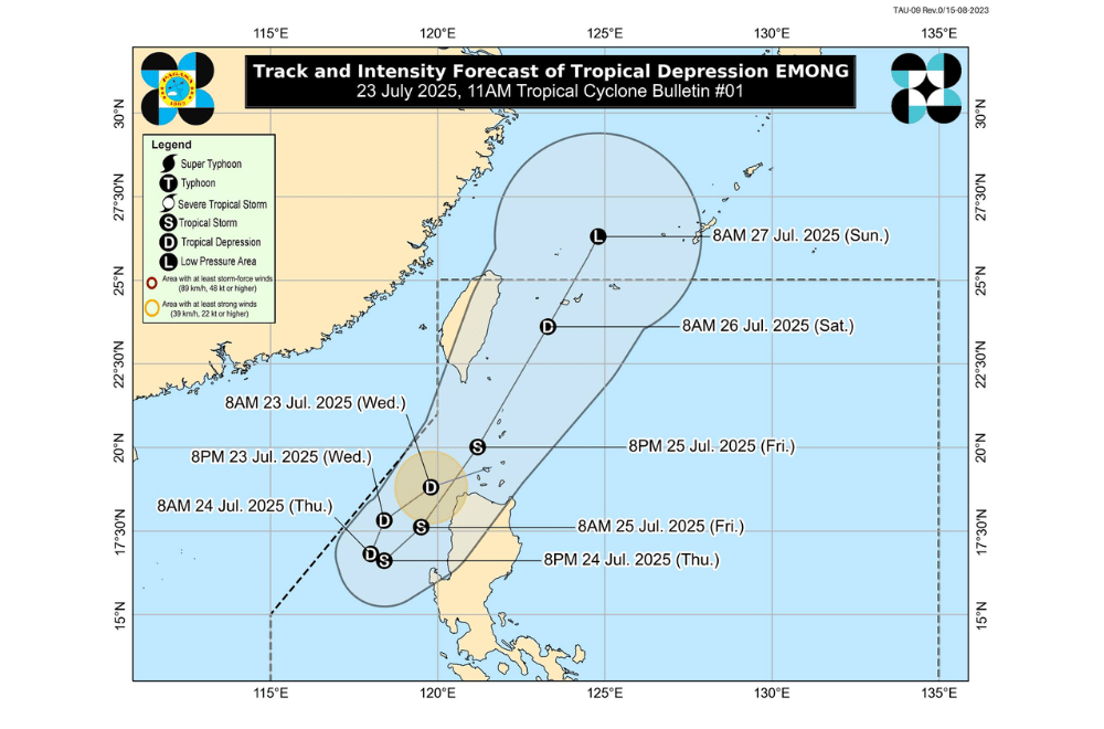
Tropical Depression #EmongPH has developed west of Luzon and is moving west southwestward over the West Philippine Sea, according to the Philippine Atmospheric, Geophysical and Astronomical Services Administration (PAGASA).
It is also enhancing the Southwest Monsoon, or habagat.
As of 10 a.m. on July 23, 2025, the center of Tropical Depression #EmongPH was located approximately 115 km West Northwest of Laoag City, Ilocos Norte (18.7°N, 119.6°E).
It is moving West Southwestward at a speed of 35 km/h.
#EmongPH currently has maximum sustained winds of 45 km/h near the center, gustiness of up to 55 km/h, and central pressure of 996 hPa.
It may loop over the West Philippine Sea due to its interaction with Tropical Storm #DantePH and may later move northeastward, possibly passing near Ilocos Region, Babuyan Islands, or Batanes. A landfall is not ruled out if the system shifts eastward.
TROPICAL CYCLONE WIND SIGNAL (TCWS) NO. 1:
- Ilocos Norte
- Western portion of Ilocos Sur (Sinait, San Juan, Cabugao, Santo Domingo, Magsingal, Bantay, San Ildefonso, San Vicente, Santa Catalina, City of Vigan, Caoayan, Santa, Narvacan, Santa Maria, San Esteban, Santiago, City of Candon, Santa Lucia, Santa Cruz, Tagudin)
- Northwestern portion of La Union (City of San Fernando, San Juan, Bacnotan, Luna, Balaoan, Bangar, Bauang)
- Western portion of Pangasinan (Dasol, Burgos, Agno, Bani, Bolinao, City of Alaminos, Mabini, Anda)
SEA CONDITIONS AND STORM SURGE
No storm surge threat is expected from #EmongPH. However, enhanced monsoon conditions will bring risky sea travel in several coastal areas:
Rough seas (up to 3.5 m):
- Western seaboards of Batanes, Babuyan Islands, Zambales, Bataan, and Lubang Island
Rough seas (up to 3.0 m):
- Seaboards of Kalayaan Islands
- Northern seaboard of Ilocos Norte
- Western seaboards of Occidental Mindoro and Calamian Islands
Moderate seas (up to 2.5 m):
- Remaining seaboards of Batanes, Babuyan Islands, and Ilocos Region
- Southern seaboard of Bataan
- Western seaboards of Cavite, Batangas, and Palawan
Moderate seas (up to 2.0 m):
- Seaboards of Camarines Norte, Oriental Mindoro, Marinduque, and Romblon
- Northern and eastern seaboards of Catanduanes and Northern Samar
- Eastern seaboards of Albay, Sorsogon, Surigao del Sur, and Davao Oriental
- Western seaboard of Masbate
- Southern seaboard of Quezon
- Remaining seaboards of Batangas, Occidental Mindoro, and Palawan
- Northern seaboard of Camarines Sur
Motorbancas and similarly-sized vessels are advised to take precaution or avoid going out to sea under these conditions, especially if ill-equipped or operated by inexperienced crews.
GUSTS AND MONSOON WINDS
The enhanced Southwest Monsoon will bring strong to gale-force gusts over the following areas, especially in coastal and mountainous zones:
- Today (July 23): Zambales, Bataan, Bulacan, Aurora, Metro Manila, CALABARZON, Bicol Region, MIMAROPA, Visayas, Zamboanga del Norte, Misamis Occidental, Lanao del Norte, Camiguin, Dinagat Islands, Davao Occidental, and Davao Oriental
- Tomorrow (July 24): Central Luzon, Metro Manila, CALABARZON, Bicol Region, MIMAROPA, Visayas, Zamboanga del Norte, Misamis Occidental, Lanao del Norte, Camiguin, Davao Occidental, and Davao Oriental
- Friday (July 25): Ilocos Region, Cordillera Administrative Region, Central Luzon, Metro Manila, Bicol Region, MIMAROPA, Visayas, Zamboanga del Norte, Misamis Occidental, Lanao del Norte, Camiguin, Davao Occidental, and Davao Oriental
For local rainfall advisories and weather warnings, the public is advised to monitor updates from their nearest PAGASA Regional Services Division.
