


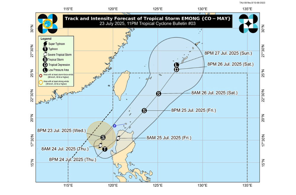
Tropical Storm #EmongPH has slightly intensified while moving southwestward over the West Philippine Sea, according to the Philippine Atmospheric, Geophysical and Astronomical Services Administration (PAGASA).
It continues to enhance the Southwest Monsoon or habagat.
As of 10 p.m. on July 23, 2025, the center of Tropical Storm #EmongPH was located approximately 235 km West of Sinait, Ilocos Sur (17.5°N, 118.3°E).
It is moving southwestward at a speed of 15 km/h.
#EmongPH currently has maximum sustained winds of 85 km/h near the center, gustiness of up to 105 km/h, and a central pressure of 990 hPa. Strong to gale-force winds extend up to 220 km from the center.
The storm may loop over the West Philippine Sea due to its interaction with Tropical Storm #DantePH, then may make landfall over Ilocos Region and pass close to Babuyan Islands. Further intensification into a typhoon is not ruled out.
TROPICAL CYCLONE WIND SIGNALS (TCWS) IN EFFECT:
TCWS No. 2
- Northwestern portion of Pangasinan (Bolinao, Anda, Bani, Agno, Burgos)
TCWS No. 1
- Ilocos Norte
- Ilocos Sur
- La Union
- Central and remaining northwestern portions of Pangasinan (Dasol, City of Alaminos, Mabini, Labrador, Sual, Binmaley, Dagupan City, Lingayen, Bugallon, Infanta, Sison, Mangaldan, San Fabian, San Jacinto, Pozorrubio, Basista, Villasis, Malasiqui, Tayug, Urbiztondo, Bautista, Mapandan, Binalonan, Aguilar, Alcala, San Manuel, Asingan, Santo Tomas, Santa Maria, City of Urdaneta, Laoac, Mangatarem, San Carlos City, Manaoag, Bayambang, Calasiao, San Nicolas, Santa Barbara)
- Northern portion of Zambales (Santa Cruz, Candelaria)
- Apayao
- Abra
- Kalinga
- Mountain Province
- Benguet
- Ifugao
- Cagayan including Babuyan Islands (Calayan, Dalupiri, Fuga, Pamuktan, Camiguin and Didicas Islands)
- Northern and western portions of Isabela (Santo Tomas, Delfin Albano, Quezon, Mallig, Quirino, Roxas, San Manuel, Aurora, San Mateo, Ramon, Cordon, Burgos, Cabatuan, Cabagan, San Pablo, Santa Maria, Tumauini, Gamu, Luna, Maconacon)
- Western portion of Nueva Vizcaya (Santa Fe, Bambang, Kayapa, Ambaguio, Bayombong, Solano, Villaverde, Bagabag, Diadi, Aritao)
SEA CONDITIONS AND STORM SURGE
A Gale Warning is in effect over the western seaboard of Northern Luzon. No storm surge is expected from #EmongPH, but enhanced monsoon conditions will bring rough to very rough seas.
Very rough seas (up to 6.0 m):
- Western seaboard of Pangasinan
Rough to very rough seas (up to 4.5 m):
- Western seaboards of Zambales and Bataan
Rough seas (up to 4.0 m):
- Seaboard of Lubang Island
- Western seaboard of Occidental Mindoro
- Eastern seaboard of Isabela
Rough seas (up to 3.5 m):
- Western seaboards of Ilocos Sur, La Union, Cavite, Batangas, northern Palawan including Calamian Islands
- Eastern seaboard of mainland Cagayan
Rough seas (up to 3.0 m):
- Seaboards of Batanes, Marinduque, Kalayaan Islands
- Western seaboard of Babuyan Island
- Southern seaboard of Quezon
- Eastern seaboard of Oriental Mindoro
- Northern and western seaboards of Romblon
- Northeastern seaboard of Aurora
Moderate to rough seas (up to 2.5 m):
- Remaining seaboards of Babuyan Islands, Bataan, Cavite
- Seaboard of Isabela, Pampanga, Bulacan, Metro Manila, Surigao del Sur
- Western seaboards of Bicol Region, southern Palawan, and Antique
- Eastern seaboard of Davao Oriental
Moderate seas (up to 2.0 m):
- Seaboards of Aklan and Northern Samar
- Remaining seaboards of mainland Cagayan, Aurora, Bicol Region, Batangas, Occidental Mindoro, Oriental Mindoro, Palawan, and Romblon
- Southwestern seaboard of Negros Occidental and Iloilo
- Western seaboard of Guimaras
Mariners of small seacrafts, including motorbancas, are advised not to venture out to sea under these conditions, especially if ill-equipped or operated by inexperienced crews.
GUSTS AND MONSOON WINDS
The enhanced Southwest Monsoon will bring strong to gale-force gusts over the following areas, especially in coastal and upland zones:
- Today (July 23): Central Luzon, Metro Manila, CALABARZON, Bicol Region, MIMAROPA, Visayas, Zamboanga del Norte, Misamis Occidental, Lanao del Norte, Camiguin, Dinagat Islands, Davao Oriental
- Tomorrow (July 24): Central Luzon, Metro Manila, CALABARZON, Bicol Region, MIMAROPA, Visayas, Zamboanga del Norte, Misamis Occidental, Lanao del Norte, Camiguin, Davao Oriental
- Friday (July 25): Isabela, Quirino, Nueva Vizcaya, Central Luzon, Metro Manila, Bicol Region, MIMAROPA, Visayas, Zamboanga del Norte, Misamis Occidental, Lanao del Norte, Camiguin, Davao Oriental
For local rainfall advisories and weather warnings, the public is advised to monitor updates from their nearest PAGASA Regional Services Division.
