


#EmongPH has intensified into a severe tropical storm while moving south-southwestward over the West Philippine Sea, according to the Philippine Atmospheric, Geophysical and Astronomical Services Administration (PAGASA).
It continues to enhance the Southwest Monsoon or habagat.
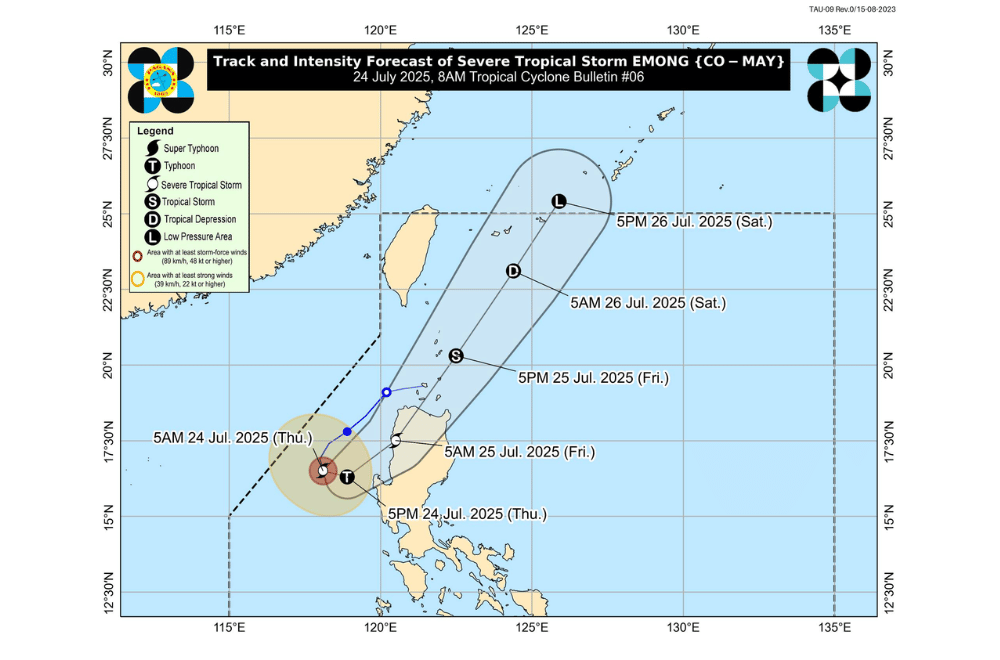
As of 7 a.m. on July 24, 2025, the center of Severe Tropical Storm #EmongPH was located approximately 245 km west of Bacnotan, La Union (16.5°N, 118.1°E).
It is moving south-southwestward at 15 km/h.
#EmongPH currently has maximum sustained winds of 110 km/h near the center, gustiness of up to 135 km/h, and a central pressure of 980 hPa. Strong to storm-force winds extend up to 220 km from the center.
The storm may pass close to Pangasinan this afternoon and could make landfall over the Ilocos Region tonight or early Friday. It may strengthen into a typhoon before landfall.
TROPICAL CYCLONE WIND SIGNALS (TCWS) IN EFFECT:
TCWS No. 3
- Northern portion of Pangasinan (Anda, Bolinao, Bani)
- Western portion of La Union (Luna, Balaoan, Bacnotan, San Juan, City of San Fernando, Bauang, Caba, Bangar)
TCWS No. 2
- Ilocos Norte
- Ilocos Sur
- Rest of La Union
- Apayao
- Abra
- Kalinga
- Mountain Province
- Ifugao
- Benguet
- Central portion of Pangasinan (Agno, Burgos, Mabini, City of Alaminos, Sual, Labrador, Bugallon, Infanta, Dasol, Lingayen, Binmaley, Dagupan City, Calasiao, Santa Barbara, Mangaldan, Mapandan, Manaoag, Laoac, Binalonan, San Manuel, San Nicolas, Pozorrubio, Sison, San Fabian, San Jacinto)
- Northwestern and western portions of mainland Cagayan (Rizal, Santa Praxedes, Claveria)
- Western portion of Nueva Vizcaya (Kayapa, Santa Fe)
TCWS No. 1
- Batanes
- Rest of Cagayan including Babuyan Islands
- Western and central portions of Isabela (Santo Tomas, Delfin Albano, Quezon, Mallig, Quirino, Roxas, San Manuel, Aurora, San Mateo, Ramon, Cordon, Burgos, Cabatuan, Cabagan, San Pablo, Santa Maria, Tumauini, Gamu, Luna, Maconacon, Alicia, San Mariano, Naguilian, San Guillermo, City of Cauayan, Echague, Ilagan City, Angadanan, Benito Soliven, City of Santiago, Reina Mercedes, San Agustin, Divilacan, San Isidro, Jones)
- Rest of Nueva Vizcaya
- Quirino
- Rest of Pangasinan
- Northern and central portions of Zambales (Santa Cruz, Candelaria, Masinloc, Palauig, Iba, Botolan, Cabangan)
- Tarlac
- Western and central portions of Nueva Ecija (Carranglan, Lupao, Talugtug, Cuyapo, Nampicuan, Guimba, Science City of Muñoz, San Jose City, Pantabangan, Rizal, Llanera, Talavera, Santo Domingo, Quezon, Licab, Aliaga, Zaragoza, San Antonio, Jaen, Cabanatuan City, Santa Rosa, General Mamerto Natividad, Palayan City, Bongabon, Laur)
SEA CONDITIONS AND STORM SURGE
A Gale Warning is in effect over the western seaboards of Luzon.
A storm surge of 1.0 to 2.0 meters is possible within the next 36 hours in low-lying and exposed coastal areas of Batanes, Cagayan including Babuyan Islands, Ilocos Norte, Ilocos Sur, La Union, Pangasinan, and Zambales.
Very rough to high seas (up to 14.0 m):
- Western seaboards of Ilocos Sur and La Union
Very rough seas (up to 11.0 m):
- Seaboards of Pangasinan
Rough to very rough seas (up to 8.0 m):
- Western seaboard of Zambales
Rough seas (up to 6.0 m):
- Western seaboard of Bataan
Rough seas (up to 4.5 m):
- Western seaboards of Batangas, Lubang Islands, Occidental Mindoro
Moderate to rough seas (up to 4.0 m):
- Eastern seaboards of Isabela and mainland Cagayan
Rough seas (up to 3.5 m):
- Western seaboards of northern Palawan including Calamian Islands
- Northeastern seaboard of Aurora
Rough seas (up to 3.0 m):
- Seaboards of Batanes, Marinduque, Kalayaan Islands
- Seaboards of Babuyan Islands
- Southern seaboard of Quezon
- Eastern seaboard of Oriental Mindoro
- Northern and western seaboards of Romblon
- Remaining seaboards of Bataan
Moderate to rough seas (up to 2.5 m):
- Remaining seaboards of mainland Cagayan, Aurora, Cavite
- Seaboards of Pampanga, Bulacan, Metro Manila, Surigao del Sur
- Western seaboards of southern Palawan and Antique
- Eastern seaboard of Catanduanes and Davao Oriental
Moderate seas (up to 2.0 m):
- Seaboards of Aklan, Northern Samar
- Remaining seaboards of Bicol Region, Batangas, Quezon, Occidental and Oriental Mindoro, Palawan, and Romblon
- Southwestern seaboard of Negros Occidental and Iloilo
- Western seaboard of Guimaras
Mariners of small seacrafts, including motorbancas, are advised not to venture out to sea under these conditions, especially if ill-equipped or operated by inexperienced crews.
GUSTS AND MONSOON WINDS
The enhanced Southwest Monsoon will bring strong to gale-force gusts over coastal and upland areas:
- Today (July 24): Metro Manila, Central Luzon, CALABARZON, Bicol Region, MIMAROPA, Visayas, Zamboanga del Norte, Misamis Occidental, Lanao del Norte, Camiguin
- Tomorrow (July 25): Metro Manila, Central Luzon, CALABARZON, Bicol Region, MIMAROPA, Visayas, Zamboanga del Norte, Misamis Occidental, Lanao del Norte, Camiguin
- Saturday (July 26): Isabela, Quirino, Nueva Vizcaya, Central Luzon, Metro Manila, Bicol Region, MIMAROPA, Visayas, Zamboanga del Norte, Misamis Occidental, Lanao del Norte, Camiguin
For local rainfall advisories and weather warnings, the public is advised to monitor updates from their nearest PAGASA Regional Services Division.
