


Tropical Storm #DantePH has maintained its strength while accelerating north northwestward over the Philippine Sea, continuing to enhance the Southwest Monsoon or habagat, according to the Philippine Atmospheric, Geophysical and Astronomical Services Administration (PAGASA).
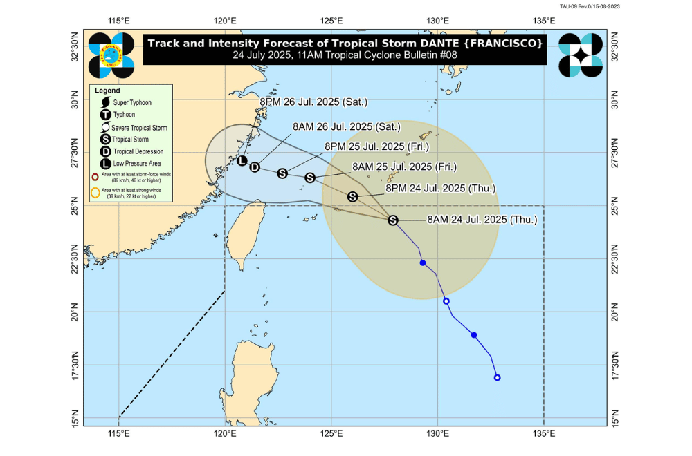
As of 10 a.m. on July 24, 2025, the center of Tropical Storm #DantePH was located approximately 735 km east northeast of Itbayat, Batanes (24.3°N, 127.9°E).
It is moving north northwestward at a faster pace of 30 km/h.
#DantePH has maximum sustained winds of 75 km/h near the center, gustiness of up to 90 km/h, and a central pressure of 994 hPa. Strong to gale-force winds extend outward up to 550 km from its center.
The storm is expected to continue moving west northwestward over the Philippine Sea as it approaches the Ryukyu Islands. It may exit the Philippine Area of Responsibility (PAR) later this afternoon or evening.
No Wind Signal is currently in effect due to #DantePH.
SEA CONDITIONS AND STORM SURGE
No storm surge threat is expected from #DantePH. However, the enhanced monsoon will bring dangerous sea conditions in several coastal waters:
Very rough to high seas (up to 14.0 m):
- Western seaboards of Ilocos Sur and La Union
Very rough seas (up to 11.0 m):
- Seaboards of Pangasinan
Rough to very rough seas (up to 8.0 m):
- Western seaboard of Zambales
Rough to very rough seas (up to 6.0 m):
- Western seaboard of Bataan
Rough seas (up to 4.5 m):
- Western seaboards of Batangas, Lubang Islands, and Occidental Mindoro
Rough seas (up to 4.0 m):
- Eastern seaboards of Isabela and mainland Cagayan
Rough seas (up to 3.5 m):
- Western seaboards of northern Palawan including Calamian Islands
- Northeastern seaboard of Aurora
Rough seas (up to 3.0 m):
- Seaboards of Batanes, Marinduque, Kalayaan Islands, and Babuyan Islands
- Southern seaboard of Quezon
- Eastern seaboard of Oriental Mindoro
- Northern and western seaboards of Romblon
- Remaining seaboards of Bataan
Moderate to rough seas (up to 2.5 m):
- Remaining seaboards of mainland Cagayan, Aurora, and Cavite
- Seaboards of Pampanga, Bulacan, Metro Manila, and Surigao del Sur
- Western seaboards of southern Palawan and Antique
- Eastern seaboard of Catanduanes and Davao Oriental
Moderate seas (up to 2.0 m):
- Seaboards of Aklan and Northern Samar
- Remaining seaboards of Bicol Region, Batangas, Quezon, Occidental Mindoro, Oriental Mindoro, Palawan, and Romblon
- Southwestern seaboard of Negros Occidental and Iloilo
- Western seaboard of Guimaras
Small sea vessels, including motorbancas, are advised not to sail under these conditions unless properly equipped and handled by experienced crew. Mariners already at sea should seek shelter.
GUSTS AND MONSOON WINDS
The enhanced Southwest Monsoon will bring strong to gale-force gusts in coastal and upland areas:
- Today (July 24): Central Luzon (areas not under Wind Signal), Metro Manila, CALABARZON, Bicol Region, MIMAROPA, Visayas, Zamboanga del Norte, Misamis Occidental, Lanao del Norte, Camiguin, Dinagat Islands, and Davao Oriental
- Tomorrow (July 25): Central Luzon (areas not under Wind Signal), Metro Manila, CALABARZON, Bicol Region, MIMAROPA, Visayas, Zamboanga del Norte, Misamis Occidental, Lanao del Norte, and Camiguin
- Saturday (July 26): Batanes, Babuyan Islands, Ilocos Region, Isabela, Quirino, Nueva Vizcaya, Central Luzon, Metro Manila, Bicol Region, MIMAROPA, Visayas, Zamboanga del Norte, Misamis Occidental, Lanao del Norte, and Camiguin
The public is advised to monitor local updates and weather advisories from PAGASA Regional Services Divisions and take precautionary measures.
