


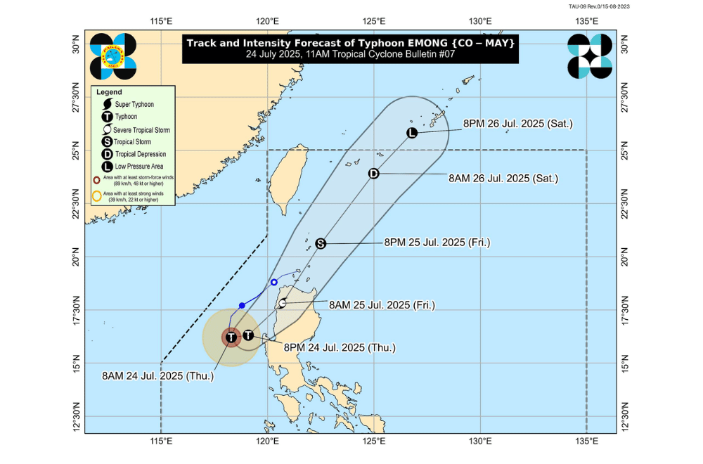
#EmongPH has intensified into a Typhoon and is now moving slowly south southeastward over the West Philippine Sea, according to the Philippine Atmospheric, Geophysical and Astronomical Services Administration (PAGASA).
It continues to enhance the Southwest Monsoon or habagat, bringing gusty conditions across large parts of Luzon and Visayas.
As of 10 a.m. on July 24, 2025, the center of Typhoon #EmongPH was located about 210 km west of Dagupan City, Pangasinan (16.2°N, 118.4°E).
It has maximum sustained winds of 120 km/h near the center, gustiness of up to 150 km/h, and a central pressure of 975 hPa. It is moving slowly south southeastward. Strong to typhoon-force winds extend up to 150 km from the center.
The typhoon is forecast to turn northeastward later today and may make landfall over La Union or Ilocos Sur by Friday morning. A close approach to northwestern Pangasinan is also possible.
TROPICAL CYCLONE WIND SIGNALS (TCWS) IN EFFECT:
TCWS No. 3
- Northern portion of Pangasinan (Anda, Bolinao, Bani)
- Western portion of La Union (Luna, Balaoan, Bacnotan, San Juan, City of San Fernando, Bauang, Caba, Bangar)
- Southwestern portion of Ilocos Sur (San Esteban, Santiago, City of Candon, Santa Lucia, Santa Cruz, Tagudin)
TCWS No. 2
- Ilocos Norte
- Rest of Ilocos Sur
- Rest of La Union
- Central portion of Pangasinan (Agno, Burgos, Mabini, City of Alaminos, Sual, Labrador, Bugallon, Infanta, Dasol, Lingayen, Binmaley, Dagupan City, Calasiao, Santa Barbara, Mangaldan, Mapandan, Manaoag, Laoac, Binalonan, San Manuel, San Nicolas, Pozorrubio, Sison, San Fabian, San Jacinto)
- Apayao
- Kalinga
- Abra
- Mountain Province
- Ifugao
- Benguet
- Babuyan Islands
- Northern and western portion of mainland Cagayan (Rizal, Santa Praxedes, Claveria, Sanchez-Mira, Pamplona, Abulug, Ballesteros, Aparri, Camalaniugan, Allacapan, Buguey, Santa Teresita, Santa Ana, Gonzaga, Lal-Lo, Lasam, Santo Niño, Piat, Tuao)
- Western portion of Nueva Vizcaya (Kayapa, Santa Fe)
TCWS No. 1
- Batanes
- Rest of Cagayan
- Western and central portions of Isabela (Santo Tomas, Delfin Albano, Quezon, Mallig, Quirino, Roxas, San Manuel, Aurora, San Mateo, Ramon, Cordon, Burgos, Cabatuan, Cabagan, San Pablo, Santa Maria, Tumauini, Gamu, Luna, Maconacon, Alicia, San Mariano, Naguilian, San Guillermo, City of Cauayan, Echague, Ilagan City, Angadanan, Benito Soliven, City of Santiago, Reina Mercedes, San Agustin, Divilacan, San Isidro, Jones)
- Rest of Nueva Vizcaya
- Quirino
- Rest of Pangasinan
- Northern and central portions of Zambales (Santa Cruz, Candelaria, Masinloc, Palauig, Iba, Botolan, Cabangan)
- Tarlac
- Western and central portions of Nueva Ecija (Carranglan, Lupao, Talugtug, Cuyapo, Nampicuan, Guimba, Science City of Muñoz, San Jose City, Pantabangan, Rizal, Llanera, Talavera, Santo Domingo, Quezon, Licab, Aliaga, Zaragoza, San Antonio, Jaen, Cabanatuan City, Santa Rosa, General Mamerto Natividad, Palayan City, Bongabon, Laur)
SEA CONDITIONS AND STORM SURGE
A Gale Warning is in effect over the western seaboards of Luzon. A storm surge of 1.0 to 2.0 meters may occur within 36 hours along low-lying or exposed coastal areas of Batanes, Cagayan, Ilocos Norte, Ilocos Sur, La Union, Pangasinan, and Zambales.
Very rough to high seas (up to 14.0 m):
- Western seaboards of Ilocos Sur and La Union
Rough to very rough seas (up to 11.0 m):
- Pangasinan
Rough seas (up to 8.0 m):
- Western Zambales
Up to 6.0 m:
- Western Bataan
Up to 4.5 m:
- Batangas, Lubang Islands, Occidental Mindoro
Up to 4.0 m:
- Eastern Isabela and mainland Cagayan
Up to 3.5 m:
- Northern Palawan, Calamian Islands, northeastern Aurora
Up to 3.0 m:
- Batanes, Marinduque, Kalayaan Islands, Babuyan Islands, Quezon (southern coast), Romblon (northern and western sides), Oriental Mindoro (eastern coast)
Up to 2.5 m:
- Remaining coasts of Babuyan Islands, Bataan, Isabela, Pampanga, Bulacan, Metro Manila, Surigao del Sur, southern Palawan, Antique, Catanduanes, Davao Oriental
Up to 2.0 m:
- Aklan, Northern Samar, Bicol Region, Occidental and Oriental Mindoro, Romblon, Palawan, Negros Occidental (southwest coast), Iloilo (southwest coast), Guimaras
Sea travel is risky for all types of vessels in affected areas. Mariners are advised to stay in port or seek shelter immediately.
GUSTS AND MONSOON WINDS
The enhanced Southwest Monsoon will continue to bring gusty conditions, especially in coastal and upland areas.
- Today (July 24): Central Luzon, Metro Manila, CALABARZON, Bicol Region, MIMAROPA, Visayas, Zamboanga del Norte, Misamis Occidental, Lanao del Norte, Camiguin
- Tomorrow (July 25): Same areas as today
- Saturday (July 26): Batanes, Babuyan Islands, Ilocos Region, Isabela, Quirino, Nueva Vizcaya, Central Luzon, Metro Manila, Bicol Region, MIMAROPA, Visayas, Zamboanga del Norte, Misamis Occidental, Lanao del Norte, Camiguin
For rainfall forecasts and more localized warnings, the public is advised to follow updates from PAGASA Regional Services Divisions.
