


Typhoon #EmongPH remains nearly stationary west of Pangasinan while maintaining its strength, according to the Philippine Atmospheric, Geophysical and Astronomical Services Administration (PAGASA).
It continues to enhance the Southwest Monsoon or habagat, bringing gusty conditions and risky sea travel over several areas in Luzon, Visayas, and Mindanao.
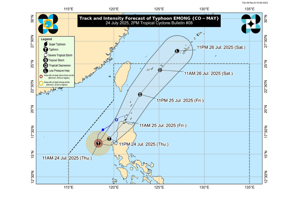
As of 1:00 p.m. on July 24, 2025, the center of Typhoon #EmongPH was located approximately 175 km west of Dagupan City, Pangasinan (16.0°N, 118.7°E).
It is currently almost stationary but is expected to move northeastward and make landfall over La Union, Ilocos Sur, or Ilocos Norte by early morning tomorrow, July 25.
#EmongPH has maximum sustained winds of 120 km/h near the center, gustiness of up to 150 km/h, and a central pressure of 975 hPa. Strong to typhoon-force winds extend up to 150 km from the center.
TROPICAL CYCLONE WIND SIGNALS (TCWS) IN EFFECT:
TCWS No. 3
- Northern portion of Pangasinan (Anda, Bolinao, Bani)
- Western portion of La Union (Luna, Balaoan, Bacnotan, San Juan, City of San Fernando, Bauang, Caba, Bangar)
- Western portion of Ilocos Sur (San Esteban, Santiago, City of Candon, Santa Lucia, Santa Cruz, Tagudin, Santo Domingo, Cabugao, Sinait, Magsingal, San Juan, Bantay, San Vicente, San Ildefonso, Santa Catalina, City of Vigan, Caoayan, Santa, Narvacan, Santa Maria, Nagbukel, Burgos, Banayoyo)
- Western portion of Abra (San Quintin, Langiden)
TCWS No. 2
- Ilocos Norte
- Rest of Ilocos Sur
- Rest of La Union
- Central portion of Pangasinan (Agno, Burgos, Mabini, City of Alaminos, Sual, Labrador, Bugallon, Infanta, Dasol, Lingayen, Binmaley, Dagupan City, Calasiao, Santa Barbara, Mangaldan, Mapandan, Manaoag, Laoac, Binalonan, San Manuel, San Nicolas, Pozorrubio, Sison, San Fabian, San Jacinto)
- Rest of Abra
- Apayao
- Kalinga
- Mountain Province
- Ifugao
- Benguet
- Babuyan Islands
- Northern and western portion of mainland Cagayan (Rizal, Santa Praxedes, Claveria, Sanchez-Mira, Pamplona, Abulug, Ballesteros, Aparri, Camalaniugan, Allacapan, Buguey, Santa Teresita, Santa Ana, Gonzaga, Lal-Lo, Lasam, Santo Niño, Piat, Tuao)
- Western portion of Nueva Vizcaya (Kayapa, Santa Fe)
TCWS No. 1
- Batanes
- Rest of Cagayan
- Western and central portions of Isabela (Santo Tomas, Delfin Albano, Quezon, Mallig, Quirino, Roxas, San Manuel, Aurora, San Mateo, Ramon, Cordon, Burgos, Cabatuan, Cabagan, San Pablo, Santa Maria, Tumauini, Gamu, Luna, Maconacon, Alicia, San Mariano, Naguilian, San Guillermo, City of Cauayan, Echague, Ilagan City, Angadanan, Benito Soliven, City of Santiago, Reina Mercedes, San Agustin, Divilacan, San Isidro, Jones)
- Rest of Nueva Vizcaya
- Quirino
- Rest of Pangasinan
- Northern and central portions of Zambales (Santa Cruz, Candelaria, Masinloc, Palauig, Iba, Botolan, Cabangan)
- Tarlac
- Western and central portions of Nueva Ecija (Carranglan, Lupao, Talugtug, Cuyapo, Nampicuan, Guimba, Science City of Muñoz, San Jose City, Pantabangan, Rizal, Llanera, Talavera, Santo Domingo, Quezon, Licab, Aliaga, Zaragoza, San Antonio, Jaen, Cabanatuan City, Santa Rosa, General Mamerto Natividad, Palayan City, Bongabon, Laur)
SEA CONDITIONS AND STORM SURGE
A Gale Warning is in effect along the western seaboards of Luzon. Storm surge of 1.0 to 3.0 meters is possible within 24 hours over low-lying and coastal areas of:
- Batanes, Cagayan (including Babuyan Islands), Isabela
- Ilocos Norte, Ilocos Sur, La Union, Pangasinan, Zambales
Very rough to high seas (up to 14.0 m):
- Western seaboards of Ilocos Sur and La Union
Rough to very rough seas (6.0 to 11.0 m):
- Pangasinan, Zambales, Bataan
Rough seas (4.5 to 8.0 m):
- Batangas, Lubang Islands, Occidental Mindoro
- Eastern seaboards of Isabela and mainland Cagayan
- Western Palawan, Calamian Islands, Aurora (NE portion)
Moderate to rough seas (2.0 to 4.0 m):
- Batanes, Babuyan Islands, Marinduque, Kalayaan Islands
- Quezon (southern), Oriental Mindoro, Romblon, Cavite, Davao Oriental, Surigao del Sur
- Bicol Region, northern Palawan, and surrounding areas
Moderate seas (up to 2.5 m):
- Remaining coastal areas in Luzon, Visayas, and parts of Mindanao
- Mariners of small vessels are advised to stay in port and avoid sea travel
GUSTS AND MONSOON WINDS
Strong to gale-force gusts may be experienced in coastal and upland areas due to the enhanced Southwest Monsoon:
- Today (July 24): Central Luzon (areas not under Wind Signal), Metro Manila, CALABARZON, Bicol Region, MIMAROPA, Visayas, Zamboanga del Norte, Misamis Occidental, Lanao del Norte, Camiguin, Dinagat Islands, and Davao Oriental
- Tomorrow (July 25): Central Luzon (areas not under Wind Signal), Metro Manila, CALABARZON, Bicol Region, MIMAROPA, Visayas, Zamboanga del Norte, Misamis Occidental, Lanao del Norte, and Camiguin.
- Saturday (July 26): Batanes, Babuyan Islands, Ilocos Region, Isabela, Quirino, Nueva Vizcaya, Central Luzon, Metro Manila, Bicol Region, MIMAROPA, Visayas, Zamboanga del Norte, Misamis Occidental, Lanao del Norte, and Camiguin.
Typhoon #EmongPH may intensify slightly before landfall. It will likely weaken after crossing northwestern Luzon and continue moving northeastward over the Luzon Strait and into the Philippine Sea.
The public is advised to stay alert for official updates from PAGASA and local disaster offices.
