


Typhoon #EmongPH remains slow-moving over the coastal waters west of Pangasinan and may make landfall late evening on Thursday, July 24, 2025, or early morning on Friday, July 25, 2025, according to the Philippine Atmospheric, Geophysical and Astronomical Services Administration (PAGASA).
It continues to enhance the Southwest Monsoon or habagat, bringing gusty conditions across Luzon and Visayas.
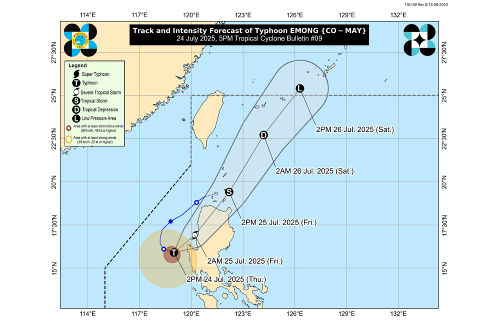
As of 4 p.m. on July 24, 2025, the center of Typhoon #EmongPH was located over the coastal waters of Burgos, Pangasinan (15.9°N, 119.2°E).
It is moving slowly east southeastward.
#EmongPH has maximum sustained winds of 120 km/h near the center, gustiness of up to 150 km/h, and a central pressure of 975 hPa. Strong to typhoon-force winds extend up to 150 km from the center.
PAGASA said #EmongPH may accelerate northeastward tonight and may make landfall over northwestern Pangasinan or nearby areas such as La Union or Ilocos Sur. It is forecast to cross Northern Luzon and pass close to Babuyan Islands by Friday afternoon.
TROPICAL CYCLONE WIND SIGNALS (TCWS) IN EFFECT:
TCWS No. 4
- Southwestern portion of Ilocos Sur (Santa Lucia, Santa Cruz, Tagudin)
- Northwestern portion of La Union (Bangar, Luna, Balaoan, Bacnotan, San Juan, City of San Fernando, Bauang)
- Extreme northwestern portion of Pangasinan (Agno, Bani, Bolinao, Anda, City of Alaminos)
TCWS No. 3
- Rest of Ilocos Sur
- Rest of La Union
- Northern and western portions of Pangasinan (Burgos, Dasol, Mabini, Lingayen, Bugallon, Infanta, Labrador, Sual, Dagupan City, San Fabian, Binmaley)
- Southern portion of Abra (San Quintin, Langiden, Manabo, Pidigan, Luba, Tubo, Villaviciosa, Pilar, Peñarrubia, San Isidro, Bangued, Danglas, La Paz, Tayum, Boliney, Sallapadan, Bucloc, Bucay, Dolores, Lagangilang, Licuan-Baay, Daguioman)
- Western portion of Mountain Province (Besao, Tadian, Sagada, Bauko)
- Western portion of Benguet (Sablan, Kapangan, Mankayan, Tuba, Bakun, Kibungan)
TCWS No. 2
- Ilocos Norte
- Rest of Pangasinan
- Rest of Abra
- Apayao
- Kalinga
- Rest of Mountain Province
- Ifugao
- Rest of Benguet
- Babuyan Islands
- Northern and western portions of mainland Cagayan (Rizal, Santa Praxedes, Claveria, Sanchez-Mira, Pamplona, Abulug, Ballesteros, Aparri, Camalaniugan, Allacapan, Buguey, Santa Teresita, Santa Ana, Gonzaga, Lal-Lo, Lasam, Santo Niño, Piat, Tuao)
- Western portion of Nueva Vizcaya (Kayapa, Santa Fe, Ambaguio, Aritao, Bambang, Bayombong, Villaverde, Solano, Bagabag)
- Northern portion of Zambales (Masinloc, Candelaria, Santa Cruz, Palauig, Iba)
TCWS No. 1
- Batanes
- Rest of Cagayan
- Western and central portions of Isabela (Santo Tomas, Delfin Albano, Quezon, Mallig, Quirino, Roxas, San Manuel, Aurora, San Mateo, Ramon, Cordon, Burgos, Cabatuan, Cabagan, San Pablo, Santa Maria, Tumauini, Gamu, Luna, Maconacon, Alicia, San Mariano, Naguilian, San Guillermo, City of Cauayan, Echague, Ilagan City, Angadanan, Benito Soliven, City of Santiago, Reina Mercedes, San Agustin, Divilacan, San Isidro, Jones)
- Quirino
- Rest of Nueva Vizcaya
- Rest of Zambales
- Tarlac
- Northern portion of Pampanga (Porac, Floridablanca, Angeles City, Mabalacat City, Magalang)
- Western and central portions of Nueva Ecija (Carranglan, Lupao, Talugtug, Cuyapo, Nampicuan, Guimba, Science City of Muñoz, San Jose City, Pantabangan, Rizal, Llanera, Talavera, Santo Domingo, Quezon, Licab, Aliaga, Zaragoza, San Antonio, Jaen, Cabanatuan City, Santa Rosa, General Mamerto Natividad, Palayan City, Bongabon, Laur)
SEA CONDITIONS AND STORM SURGE
A Gale Warning is in effect over the seaboards of Northern and Central Luzon. A storm surge of 1.0 to 3.0 meters is possible within 24 hours in low-lying coastal areas of Batanes, Cagayan (including Babuyan Islands), Isabela, Ilocos Norte, Ilocos Sur, La Union, Pangasinan, and Zambales.
Very rough to high seas (up to 14.0 m):
- Western seaboards of Ilocos Sur, La Union, and Pangasinan
Very rough seas (up to 8.0 m):
- Western seaboard of Zambales; other areas of Pangasinan
Rough to very rough seas (up to 6.0 m):
- Western seaboard of Bataan
Rough seas (up to 4.5 m):
- Batangas, Lubang Islands, Occidental Mindoro
Rough to moderate seas (2.0 to 4.0 m):
- Various seaboards in Luzon, Visayas, Palawan, Romblon, and Mindoro
All mariners, especially operators of small boats and motorbancas, are strongly advised not to go to sea and to seek shelter until sea conditions improve.
GUSTS AND MONSOON WINDS
The enhanced Southwest Monsoon will continue to bring strong to gale-force gusts over several regions:
- Today (July 24): Central Luzon (outside signal areas), Metro Manila, CALABARZON, Bicol Region, MIMAROPA, Visayas, Zamboanga del Norte, Misamis Occidental, Lanao del Norte, Camiguin
- Tomorrow (July 25): Same areas including Babuyan Islands and Davao Oriental
- Saturday (July 26): Batanes, Ilocos Region, Isabela, Quirino, Nueva Vizcaya, Central Luzon, Metro Manila, Bicol Region, MIMAROPA, Visayas, Zamboanga del Norte, Misamis Occidental, Lanao del Norte, Camiguin
For rainfall alerts and thunderstorm warnings, the public is advised to monitor updates from their nearest PAGASA Regional Services Division.
