


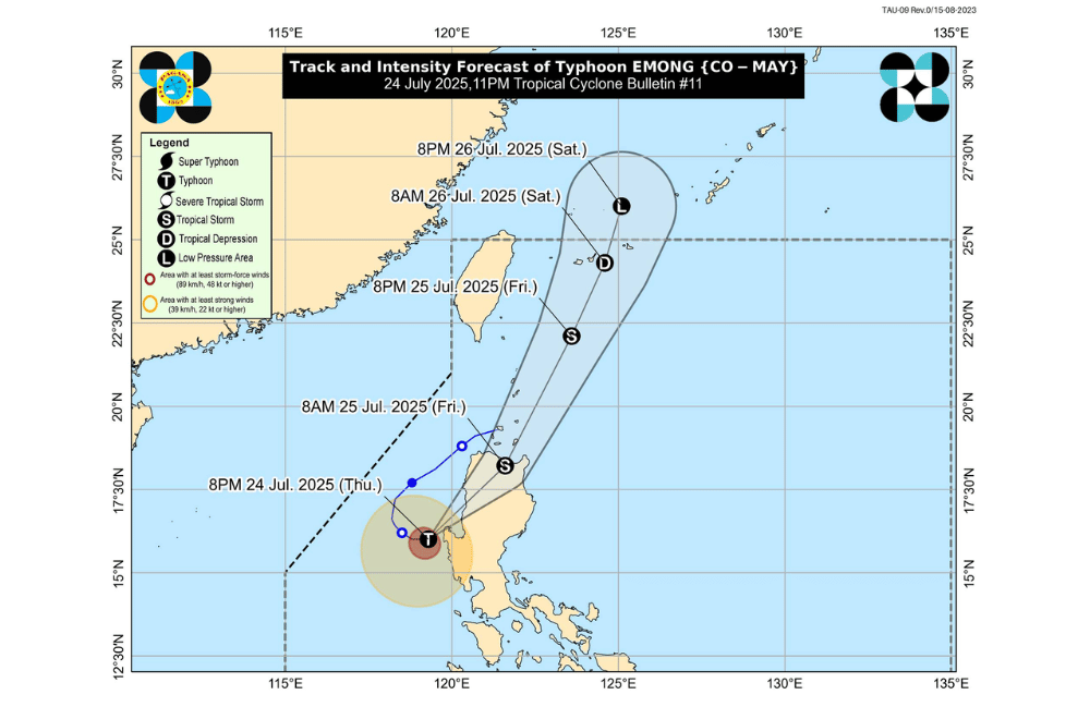
Typhoon #EmongPH made landfall over Agno, Pangasinan as of 10:40 p.m. on Thursday, July 24, 2025, and will make another landfall in La Union or Ilocos Sur, according to the Philippine Atmospheric, Geophysical and Astronomical Services Administration (PAGASA).
As of 10 p.m. on July 24, 2025, the eye of Typhoon #EmongPH was located over the coastal waters of Agno, Pangasinan (16.1°N, 119.6°E).
It is moving slowly eastward.
#EmongPH has maximum sustained winds of 120 km/h near the center, gustiness of up to 165 km/h, and a central pressure of 975 hPa. Strong to typhoon-force winds extend outward up to 240 km from the center.
The typhoon may make another landfall in La Union or Ilocos Sur before crossing the mountains of Northern Luzon. It may then move northeastward toward Babuyan Islands and Batanes by Friday.
TROPICAL CYCLONE WIND SIGNALS (TCWS) IN EFFECT:
TCWS No. 4
- Southwestern portion of La Union (Bangar, Luna, Balaoan, Bacnotan, San Juan, City of San Fernando, Bauang, Caba, Aringay, Agoo, Santo Tomas)
- Western portion of Ilocos Sur (Santa Lucia, Santa Cruz, Tagudin)
- Northern portion of Pangasinan (Agno, Bani, Bolinao, Anda, City of Alaminos, Burgos, Dasol, Mabini, Sual)
TCWS No. 3
- Southern portion of Ilocos Norte (Laoag City, San Nicolas, Sarrat, Dingras, Solsona, Nueva Era, City of Batac, Marcos, Paoay, Currimao, Banna, Pinili, Badoc)
- Rest of Ilocos Sur
- Rest of La Union
- Central portion of Pangasinan (Lingayen, Bugallon, Infanta, Dagupan City, San Fabian, Binmaley, Labrador, Sison, Pozorrubio, San Jacinto, Mangaldan, Calasiao, Santa Barbara, Mapandan, San Carlos City, Aguilar)
- Abra
- Western portion of Mountain Province (Besao, Tadian, Sagada, Bauko)
- Western portion of Benguet (Sablan, Kapangan, Mankayan, Tuba, Bakun, Kibungan)
- Extreme northern portion of Zambales (Santa Cruz)
TCWS No. 2
- Rest of Ilocos Norte
- Rest of Pangasinan
- Northern portion of Zambales (Masinloc, Candelaria, Palauig, Iba)
- Apayao
- Kalinga
- Rest of Mountain Province
- Rest of Benguet
- Ifugao
- Batanes
- Cagayan including Babuyan Islands
- Northern and western portions of Isabela (Cordon, City of Santiago, Ramon, San Isidro, Alicia, San Mateo, Cabatuan, San Manuel, Luna, Aurora, Burgos, Roxas, Quirino, Mallig, Delfin Albano, Quezon, Cabagan, Santa Maria, San Pablo, Maconacon, Santo Tomas, Tumauini, Gamu, Ilagan City, City of Cauayan, Reina Mercedes, Naguilian)
- Northwestern portion of Quirino (Diffun)
- Western and central portions of Nueva Vizcaya (Kayapa, Santa Fe, Ambaguio, Aritao, Bambang, Bayombong, Villaverde, Solano, Bagabag, Dupax del Sur, Dupax del Norte, Kasibu, Quezon, Diadi)
- Northwestern portion of Nueva Ecija (Nampicuan, Cuyapo, Talugtug, Lupao, Carranglan, Guimba)
- Northern portion of Tarlac (Mayantoc, Santa Ignacia, Gerona, Pura, Ramos, Anao, San Manuel, Moncada, Paniqui, Camiling, San Clemente)
TCWS No. 1
- Rest of Isabela
- Rest of Quirino
- Rest of Nueva Vizcaya
- Northern and central portions of Aurora (Dilasag, Casiguran, Dinalungan, Dipaculao, Maria Aurora, Baler, San Luis)
- Rest of Nueva Ecija
- Rest of Tarlac
- Western and central portions of Pampanga (Porac, Floridablanca, Angeles City, Mabalacat City, Magalang, Mexico, Bacolor, City of San Fernando, Santa Rita, Guagua, Arayat, Lubao, Santa Ana)
- Northern portion of Bataan (Dinalupihan, Hermosa, Morong)
- Rest of Zambales
SEA CONDITIONS AND STORM SURGE
A Gale Warning is in effect over the seaboards of Northern and Central Luzon. PAGASA warns of storm surge reaching 1.0 to 3.0 meters in low-lying coastal areas of Batanes, Cagayan, Babuyan Islands, Ilocos Norte, Ilocos Sur, La Union, Pangasinan, and Zambales.
Very rough to high seas (up to 14.0 m):
Western seaboards of Ilocos Sur, La Union, and Pangasinan
Very rough seas (up to 8.0 m):
Western seaboard of Zambales
Rough to very rough seas (up to 6.0 m):
Western seaboard of Bataan
Rough seas (up to 4.5 m):
- Western seaboards of Batangas, Lubang Islands, Occidental Mindoro
- Eastern seaboards of mainland Cagayan and Isabela
Rough seas (up to 3.5 m):
Western seaboards of Palawan, northeastern Aurora, eastern Babuyan Islands
Rough seas (up to 3.0 m):
Seaboards of Batanes, Babuyan Islands, Marinduque, Kalayaan Islands, parts of Quezon, Oriental Mindoro, Romblon, Ilocos Norte
Moderate to rough seas (up to 2.5 m):
Remaining seaboards of Luzon and nearby islands
Moderate seas (up to 2.0 m):
Parts of Visayas, Mindoro, Bicol Region, Guimaras, and nearby islands
Sea travel is risky for all vessels in affected areas. Mariners are advised to stay in port or seek safe harbor.
GUSTS AND MONSOON WINDS
The enhanced Southwest Monsoon will bring strong to gale-force gusts in coastal and upland areas:
- Today: Central Luzon (areas not under Wind Signal), Metro Manila, CALABARZON, Bicol Region, MIMAROPA, Visayas, Zamboanga del Norte, Misamis Occidental, Lanao del Norte, Camiguin, Dinagat Islands, and Davao Oriental.
- Tomorrow (25 July): Central Luzon (areas not under Wind Signal), Metro Manila, CALABARZON, Bicol Region, MIMAROPA, Visayas, Zamboanga del Norte, Misamis Occidental, Lanao del Norte, and Camiguin.
- Saturday (26 July): Batanes, Babuyan Islands, Ilocos Region, Cordillera Administrative Region, Isabela, Quirino, Nueva Vizcaya, Central Luzon, Metro Manila, Bicol Region, MIMAROPA, Visayas, Zamboanga del Norte, Misamis Occidental, Lanao del Norte, and Camiguin.
For local weather updates, rainfall advisories, and emergency alerts, the public is advised to monitor PAGASA and local government units.
