


#EmongPH weakened into a severe tropical storm after crossing the mountains of Northern Luzon, according to the Philippine Atmospheric, Geophysical and Astronomical Services Administration (PAGASA).
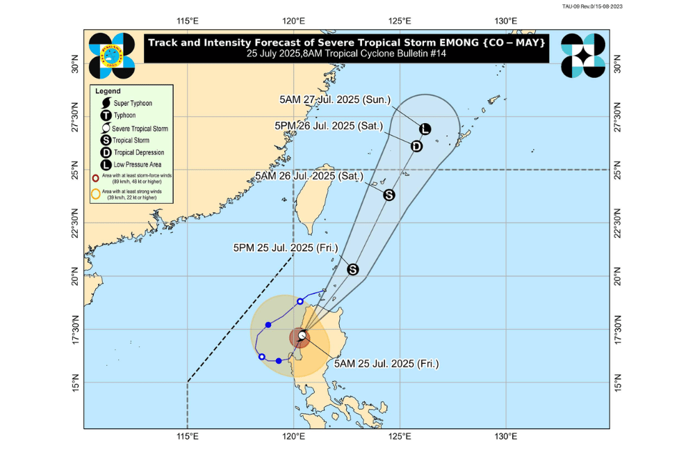
As of 7 a.m. on July 25, 2025, the center of Severe Tropical Storm #EmongPH was located over San Isidro, Abra (17.5°N, 120.6°E).
It is moving north northeastward at 25 km/h.
#EmongPH now has maximum sustained winds of 100 km/h near the center, gustiness of up to 165 km/h, and a central pressure of 985 hPa. Strong to storm-force winds extend outward up to 260 km from the center.
The storm made a second landfall in Candon City, Ilocos Sur at 5:10 a.m. It is expected to pass over the Babuyan Islands between noon and afternoon today, then near Batanes before exiting the Philippine Area of Responsibility by Saturday, July 26.
TROPICAL CYCLONE WIND SIGNALS (TCWS) IN EFFECT:
TCWS No. 3
- Ilocos Norte
- Ilocos Sur
- Northern portion of La Union (Bangar, Sudipen, Balaoan, Luna, Santol, Bacnotan, San Gabriel, Bagulin, San Juan, City of San Fernando)
- Apayao
- Abra
- Western portion of Kalinga (Balbalan, Pasil, Tinglayan, Lubuagan)
- Western portion of Mountain Province (Besao, Tadian, Sagada, Bauko, Sabangan, Bontoc, Sadanga)
- Northwestern portion of Benguet (Mankayan, Bakun, Kibungan, Kapangan)
- Northern and western portions of Cagayan (Santa Praxedes, Claveria, Sanchez-Mira, Pamplona, Abulug, Ballesteros, Rizal, Lasam, Allacapan, Aparri)
TCWS No. 2
- Batanes
- Rest of mainland Cagayan including Babuyan Islands
- Northern and western portions of Isabela (Cordon, City of Santiago, Ramon, San Isidro, Alicia, San Mateo, Cabatuan, San Manuel, Luna, Aurora, Burgos, Roxas, Quirino, Mallig, Delfin Albano, Quezon, Cabagan, Santa Maria, San Pablo, Maconacon, Santo Tomas, Tumauini, Gamu, Ilagan City, City of Cauayan, Reina Mercedes, Naguilian)
- Northwestern portion of Quirino (Diffun)
- Western and central portions of Nueva Vizcaya (Kayapa, Santa Fe, Ambaguio, Aritao, Bambang, Bayombong, Villaverde, Solano, Bagabag, Dupax del Sur, Dupax del Norte, Kasibu, Quezon, Diadi)
- Rest of Kalinga
- Rest of Mountain Province
- Ifugao
- Rest of Benguet
- Rest of La Union
- Northwestern portion of Pangasinan (Bolinao, Anda)
TCWS No. 1
- Rest of Pangasinan
- Rest of Isabela
- Rest of Quirino
- Rest of Nueva Vizcaya
- Northern and central portions of Aurora (Dilasag, Casiguran, Dinalungan, Dipaculao)
- Northern portion of Nueva Ecija (Nampicuan, Cuyapo, Guimba, Talugtug, Science City of Muñoz, San Jose City, Lupao, Carranglan, Pantabangan)
- Northern portion of Tarlac (San Clemente, Camiling, Moncada, San Manuel, Anao, Paniqui, Santa Ignacia, Mayantoc, San Jose, City of Tarlac, Victoria, Pura, Gerona, Ramos)
- Northern portion of Zambales (Santa Cruz, Candelaria, Masinloc, Palauig, Iba)
SEA CONDITIONS AND STORM SURGE
A Gale Warning is in effect over the seaboards of Northern Luzon and the western seaboards of Central and Southern Luzon.
Very rough to high seas (up to 9.0 m):
- Western seaboards of Ilocos Sur, La Union, Pangasinan
Very rough seas (up to 8.0 m):
- Western seaboard of Zambales
- Remaining seaboard of Pangasinan
Rough to very rough seas (up to 6.0 m):
- Western seaboard of Bataan
Rough seas (up to 4.5 m):
- Western seaboards of Batangas, Lubang Islands, Occidental Mindoro
- Eastern seaboards of mainland Cagayan, Isabela
Rough seas (up to 3.5 m):
- Western seaboards of Palawan (including Calamian Islands), Ilocos Norte
- Northeastern Aurora
- Eastern Babuyan Islands
Rough seas (up to 3.0 m):
- Seaboards of Batanes, Marinduque, Kalayaan Islands
- Western Babuyan Islands
- Southern Quezon
- Eastern Oriental Mindoro
- Northern and western Romblon
Moderate to rough seas (up to 2.5 m):
- Remaining Babuyan Islands, Bataan, Aurora, Cavite
- Seaboards of Isabela, Pampanga, Bulacan, Metro Manila, Surigao del Sur
- Western Bicol Region, southern Palawan, Antique
- Eastern Davao Oriental
Moderate seas (up to 2.0 m):
- Seaboards of Aklan, Northern Samar
- Remaining coasts of Cagayan, Aurora, Bicol Region, Batangas, Occidental Mindoro, Oriental Mindoro, Palawan, Romblon
- Southwestern Negros Occidental, Iloilo
- Western Guimaras
Mariners of small seacrafts, including motorbancas, are advised not to venture out to sea under these conditions, especially if ill-equipped or operated by inexperienced crews.
GUSTS AND MONSOON WINDS
The enhanced Southwest Monsoon will bring strong to gale-force gusts over the following areas, especially in coastal and upland zones:
- Today (July 25): Central Luzon, Metro Manila, CALABARZON, Bicol Region, MIMAROPA, Visayas, Zamboanga del Norte, Misamis Occidental, Lanao del Norte, Camiguin, Dinagat Islands, Davao Oriental
- Tomorrow (July 26): Ilocos Region, Cordillera, Cagayan Valley, Central Luzon, Metro Manila, CALABARZON, Bicol Region, MIMAROPA, Visayas, Zamboanga del Norte, Misamis Occidental, Lanao del Norte
- Sunday (July 27): Ilocos Region, Cordillera, Cagayan Valley, Central Luzon, Metro Manila, Bicol Region, MIMAROPA, Visayas
For local rainfall advisories and weather warnings, the public is advised to monitor updates from their nearest PAGASA Regional Services Division.
