


Severe Tropical Storm #EmongPH continues too weaken as it moves north northeastward over the Cordillera region and is about to exit Luzon’s landmass, according to the Philippine Atmospheric, Geophysical and Astronomical Services Administration (PAGASA).
It continues to enhance the Southwest Monsoon or habagat.
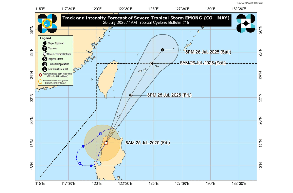
As of 10 a.m. on July 25, 2025, the center of Severe Tropical Storm #EmongPH was located in the vicinity of Calanasan, Apayao (18.4°N, 121.0°E).
It is moving north northeastward at a speed of 40 km/h.
#EmongPH currently has maximum sustained winds of 95 km/h near the center, gustiness of up to 160 km/h, and a central pressure of 990 hPa. Strong to storm-force winds extend up to 200 km from the center.
The storm is expected to pass near or over the Babuyan Islands and Batanes later today before exiting the Philippine Area of Responsibility (PAR) by tomorrow morning, July 26. It may gradually weaken into a remnant low by tomorrow evening.
TROPICAL CYCLONE WIND SIGNALS (TCWS) IN EFFECT:
TCWS No. 3
- Northeastern portion of Ilocos Norte (Bangui, Pagudpud, Dumalneg, Piddig, Vintar, Adams, Carasi)
- Northern portion of Apayao (Calanasan, Luna)
- Northwestern portion of mainland Cagayan (Santa Praxedes, Claveria, Sanchez-Mira, Pamplona)
TCWS No. 2
- Rest of Ilocos Norte, the northern portion of Ilocos Sur (Santa, Caoayan, City of Vigan, Bantay, Santa Catalina, San Vicente, Santo Domingo, San Ildefonso, Magsingal, San Juan, Cabugao, Sinait)
- Rest of Apayao
- Northern portion of Abra (Pidigan, San Juan, Tayum, Langiden, Sallapadan, Lagangilang, Danglas, La Paz, Licuan-Baay, Tineg, Malibcong, Peñarrubia, San Isidro, San Quintin, Dolores, Lagayan, Bangued, Bucay, Lacub)
- Batanes
- Northern and western portion of mainland Cagayan (Piat, Camalaniugan, Tuao, Buguey, Aparri, Allacapan, Rizal, Lasam, Ballesteros, Abulug, Santo Niño)
TCWS No. 1
- Rest of Ilocos Sur
- Northern portion of La Union (Luna, Santol, City of San Fernando, San Juan, Bagulin, Bangar, San Gabriel, Bacnotan, Sudipen, Balaoan)
- Rest of Abra
- Northern portion of Benguet (Mankayan, Kapangan, Atok, Kabayan, Kibungan, Bakun, Buguias)
- Kalinga
- Mountain Province
- Ifugao
- Rest of mainland Cagayan
- Northern portion of Isabela (Quirino, Mallig, Quezon, Delfin Albano, Tumauini, Maconacon, San Pablo, Santa Maria, Cabagan, Santo Tomas, Roxas, San Manuel)
SEA CONDITIONS AND STORM SURGE
Storm surge of 1.0 to 3.0 meters is possible within 24 hours in low-lying or exposed coastal areas of: Batanes, Babuyan Islands, mainland Cagayan, Isabela, Ilocos Norte, Ilocos Sur, La Union, Pangasinan, and Zambales.
A Gale Warning is in effect over the seaboards of Northern Luzon and the western seaboards of Central and Southern Luzon.
Very rough to high seas (up to 9.0 m):
- Eastern seaboards of mainland Cagayan and Isabela
Rough to very rough seas (up to 8.0 m):
- Western seaboards of Ilocos Sur, La Union, Pangasinan, and Zambales
Rough seas (up to 6.0 m):
- Remaining seaboards of Batanes and Cagayan, and the seaboard of Ilocos Norte
Moderate to rough seas (up to 4.5 m):
- Western seaboards of Bataan and Occidental Mindoro including Lubang Islands
Sea travel is risky for all types of vessels in affected areas. Mariners are advised to stay in port or seek safe harbor until conditions improve.
MONSOON GUSTS AND WIND CONDITIONS
The enhanced Southwest Monsoon will continue to bring strong to gale-force gusts, especially in coastal and upland areas:
- Today (July 25): Central Luzon (areas not under Wind Signal), Metro Manila, CALABARZON, Bicol Region, MIMAROPA, Visayas, Zamboanga del Norte, Misamis Occidental, Lanao del Norte, Camiguin, Dinagat Islands, and Davao Oriental.
- Tomorrow (July 26): Ilocos Region, Cordillera Administrative Region, Cagayan Valley (areas not under Wind Signal), Central Luzon, Metro Manila, CALABARZON, Bicol Region, MIMAROPA, Visayas, Zamboanga del Norte, Misamis Occidental, and Lanao del Norte
- Sunday (July 27): Ilocos Region, Cordillera Administrative Region, Cagayan Valley, Central Luzon, Metro Manila, Bicol Region, MIMAROPA, and Visayas.
For local updates on rainfall or flood advisories, the public is advised to monitor bulletins from the nearest PAGASA Regional Services Division.
