


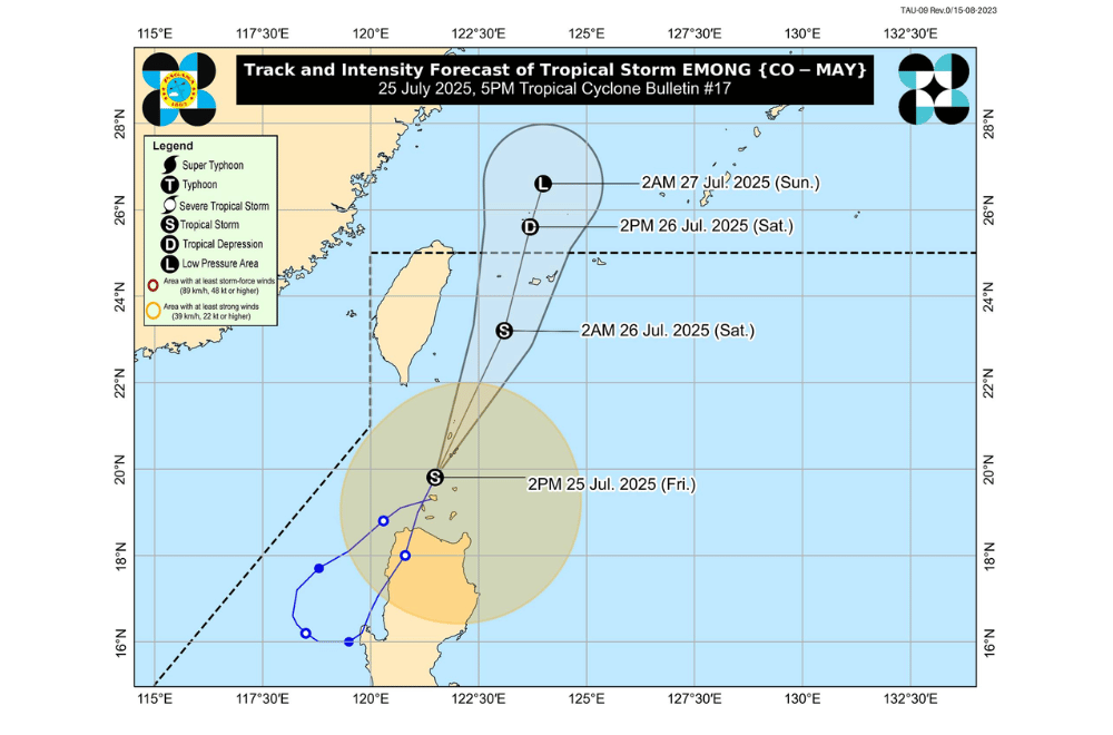
Tropical Storm #EmongPH has passed close to the Babuyan Islands and is now approaching Batanes while continuing to weaken, according to the Philippine Atmospheric, Geophysical and Astronomical Services Administration (PAGASA).
As of 4 p.m. on July 25, 2025, the center of Tropical Storm #EmongPH was located over the coastal waters of Sabtang, Batanes (20.3°N, 121.9°E).
It is moving north northeastward at a speed of 40 km/h.
#EmongPH currently has maximum sustained winds of 85 km/h near the center, gustiness of up to 115 km/h, and a central pressure of 992 hPa. Strong to gale-force winds extend up to 400 km from the center.
The storm is expected to exit the Philippine Area of Responsibility (PAR) tomorrow morning, July 26. It may weaken into a remnant low by tomorrow evening.
TROPICAL CYCLONE WIND SIGNALS (TCWS) IN EFFECT:
TCWS No. 2
- Batanes
- Babuyan Islands
TCWS No. 1
- Ilocos Norte
- Apayao
- Mainland Cagayan
SEA CONDITIONS AND STORM SURGE
A Gale Warning is in effect over the seaboard of Northern Luzon.
High seas (up to 5.5 m):
- Seaboards of Batanes and Babuyan Islands
- Northern seaboard of mainland Cagayan
Rough to very rough seas (up to 4.5 m):
- Remaining seaboard of Cagayan
- Seaboard of Isabela
Rough seas (up to 4.0 m):
- Seaboards of Ilocos Norte, Ilocos Sur, La Union, Pangasinan, and Zambales
- Western seaboards of Bataan and Occidental Mindoro including Lubang Islands
Moderate to rough seas (up to 3.5 m):
- Northeastern seaboard of Aurora
- Western seaboards of Cavite, Batangas, and Palawan including Calamian Islands
Moderate seas (up to 2.5 m):
- Seaboards of Pampanga, Bulacan, Metro Manila, Marinduque, Kalayaan Islands, Cuyo Islands, Cagayancillo Islands, and Antique
- Remaining seaboards of Bataan, Aurora, Cavite, Batangas, and Calamian Islands
- Southern seaboard of Quezon
- Eastern seaboard of Oriental Mindoro
- Northern and western seaboards of Romblon
- Western seaboard of Aklan including Caluya Islands
Moderate seas (up to 2.0 m):
- Seaboards of Northern Samar and Surigao del Sur
- Remaining seaboards of Bicol Region, Quezon, Oriental Mindoro, Palawan, and Romblon
- Southwestern seaboard of Negros Occidental and Iloilo
- Western seaboard of Guimaras
- Eastern seaboards of Catanduanes and Davao Oriental
Sea travel is risky for all types of vessels in affected areas. Mariners are advised to stay in port or seek safe harbor until conditions improve.
MONSOON GUSTS AND WIND CONDITIONS
The enhanced Southwest Monsoon will bring strong to gale-force gusts, especially in coastal and upland areas:
- Today (July 25): Ilocos Region, Cordillera Administrative Region, Cagayan Valley, Central Luzon, Metro Manila, CALABARZON, MIMAROPA, Bicol Region, Visayas, and Dinagat Islands
- Tomorrow (July 26) and Sunday (July 27): Batanes, Babuyan Islands, Ilocos Region, Cordillera Administrative Region, Nueva Vizcaya, Quirino, Aurora, Zambales, Bataan, Rizal, Quezon, Cavite, Batangas, Occidental Mindoro, Oriental Mindoro, Palawan, Romblon, Bicol Region, Western Visayas, Northern Samar, and Negros Occidental
For local updates on rainfall or flood advisories, the public is advised to monitor bulletins from the nearest PAGASA Regional Services Division.
