


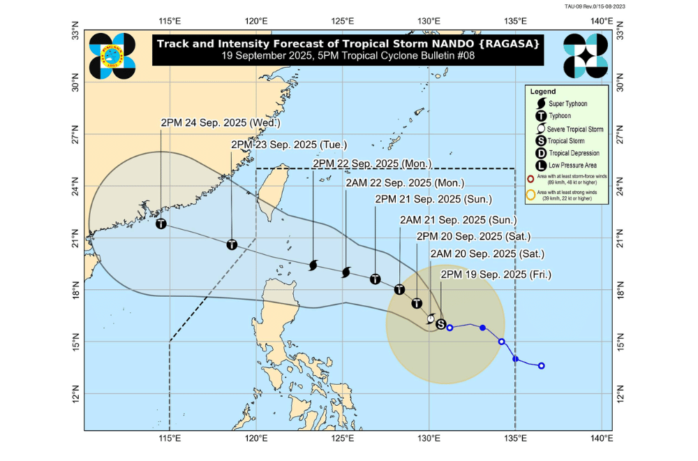
Tropical Storm #NandoPH grew stronger on Friday, September 18, 2025, as it moved slowly west northwest over the Philippine Sea, with forecasters warning it could reach super typhoon strength early next week.
At 4 p.m., PAGASA said Nando was 905 kilometers east of Central Luzon, packing maximum sustained winds of 85 kilometers per hour and gusts of up to 105 kph.
It was moving west northwest at 10 kph, with strong to gale-force winds extending up to 400 kilometers from its center.
No wind signals have been raised yet, but Signal No. 1 is expected over parts of Northern Luzon by morning on Saturday, September 20.
PAGASA added that the highest possible warning level, Signal No. 5, may be raised if Nando intensifies as expected.
The storm is forecast to continue strengthening. It may reach typhoon category by Saturday and could become a super typhoon by Monday, September 22, as it nears the Babuyan Islands.
The center of Nando may pass close to or make landfall over the islands between afternoon on Monday and early morning on Tuesday, September 23 before exiting the Philippine Area of Responsibility (PAR) later that day.
Nando is also expected to enhance the southwest monsoon, which will bring strong winds and heavy rains to parts of Luzon, Visayas, and Mindanao over the weekend. By Sunday, areas such as CALABARZON, the Bicol Region, Visayas, Northern Mindanao, and Caraga may experience monsoon rains and gusty conditions.
Coastal conditions are also expected to worsen. PAGASA warned that storm surge advisories may be raised over Northern Luzon starting Saturday, with waves possibly reaching up to 14 meters as the storm approaches.
Authorities urged residents, especially in high-risk areas, to stay alert and follow the guidance of local officials.
