


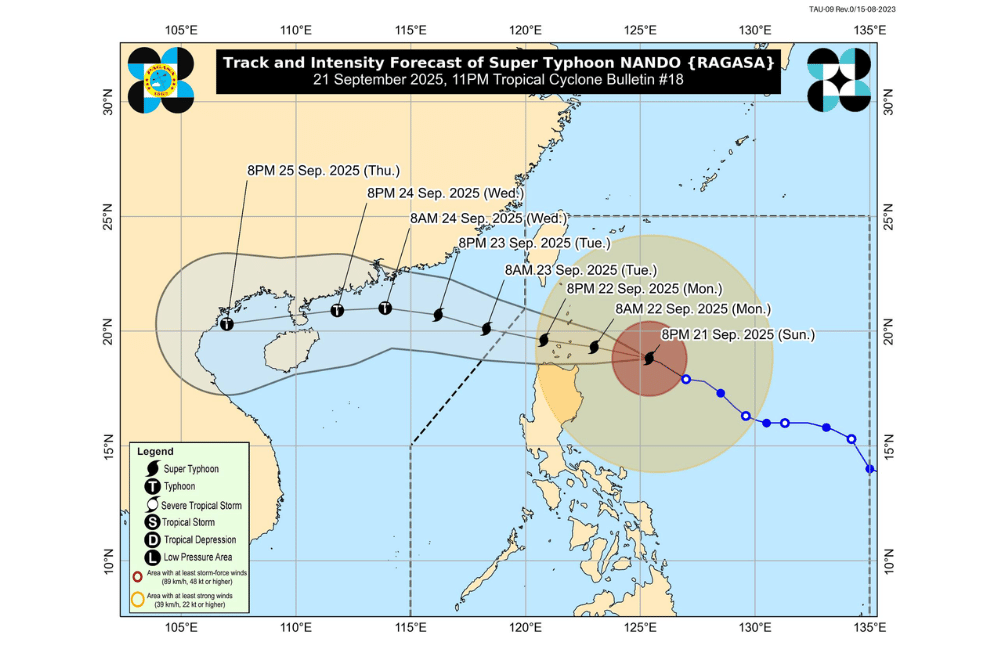
Several areas in Northern Luzon are now under Tropical Cyclone Wind Signal No. 3 as Super Typhoon #NandoPH continues to strengthen while moving closer to the region late Sunday, September 21, 2025, the state weather bureau said.
In its 11:00 p.m. advisory, PAGASA said the eye of Nando was estimated at 350 km east northeast of Aparri, Cagayan, or 360 km east of Calayan, Cagayan.
The super typhoon now has maximum sustained winds of 205 km/h near the center, gusts of up to 250 km/h, and a central pressure of 915 hPa. It is moving west northwestward at 15 km/h, with strong to typhoon-force winds extending outwards up to 600 km from the center.
Areas under Wind Signal No. 3 (storm-force winds, 89–117 km/h)
- Batanes
- Babuyan Islands
- Northern and central portions of Cagayan (Santa Ana, Gonzaga, Lal-Lo, Gattaran, Baggao, Alcala, Santo Niño, Lasam, Allacapan, Camalaniugan, Buguey, Santa Teresita, Aparri, Ballesteros, Abulug, Pamplona, Sanchez-Mira, Claveria, Santa Praxedes, Rizal)
- Northern and central portions of Apayao (Flora, Santa Marcela, Pudtol, Luna, Calanasan, Kabugao)
- Northern portion of Ilocos Norte (Carasi, Piddig, Vintar, Bacarra, Pasuquin, Burgos, Bangui, Dumalneg, Pagudpud, Adams)
Areas under Wind Signal No. 2 (gale-force winds, 62–88 km/h)
- The rest of Cagayan
- Northern and central portions of Isabela (San Mariano, Ilagan City, Tumauini, Cabagan, Palanan, Divilacan, Maconacon, San Pablo, Santa Maria, Santo Tomas, Delfin Albano, Quezon, Quirino, Mallig, Gamu, Burgos, Dinapigue, Roxas, San Manuel, San Mateo, Aurora, Cabatuan, Luna, Reina Mercedes, Naguilian, Benito Soliven, City of Cauayan, Alicia, Angadanan, San Guillermo)
- The rest of Apayao
- Abra
- Kalinga
- Eastern and central portions of Mountain Province (Paracelis, Natonin, Barlig, Sadanga, Bontoc, Besao, Sagada)
- Eastern portion of Ifugao (Alfonso Lista, Aguinaldo)
- The rest of Ilocos Norte
- Northern portion of Ilocos Sur (Cabugao, Sinait, San Juan, Magsingal, Santo Domingo, Bantay, San Ildefonso, San Vicente, Santa Catalina, City of Vigan, Caoayan, Santa, Nagbukel, Narvacan, Santa Maria, San Emilio, Burgos, Santiago, San Esteban, Lidlidda, Banayoyo, Quirino)
Areas under Wind Signal No. 1 (strong winds, 39–61 km/h)
- The rest of Isabela
- Quirino
- Nueva Vizcaya
- The rest of Mountain Province
- The rest of Ifugao
- Benguet
- The rest of Ilocos Sur
- La Union
- Pangasinan
- Aurora
- Nueva Ecija
- Bulacan
- Tarlac
- Pampanga
- Zambales
- Northern portion of Quezon (General Nakar) including Polillo Islands
PAGASA warned of life-threatening storm surges over low-lying and exposed coastal areas in Batanes, Cagayan including Babuyan Islands, Ilocos Norte, and Ilocos Sur, with peak heights possibly exceeding three meters within 24 hours.
A Gale Warning is also in effect over the seaboards of Northern Luzon and the eastern seaboard of Central Luzon. Seas may reach up to 14 meters over Batanes and Babuyan Islands and 12 meters over the northern seaboard of Ilocos Norte. Sea travel is risky for all vessels.
The Southwest Monsoon, enhanced by Nando, will bring strong to gale-force gusts over Metro Manila, Central Luzon, CALABARZON, Bicol Region, MIMAROPA, Visayas, Northern Mindanao, Caraga, and other regions through Tuesday.
PAGASA said Nando will continue to move westward on Monday, September 22, towards Babuyan Islands. The super typhoon may pass close or make landfall over the area by late morning or early afternoon before exiting the Philippine Area of Responsibility (PAR) by early Tuesday, September 23.
Nando is expected to maintain its strength or intensify further before nearing Extreme Northern Luzon.
Authorities urged residents and local disaster offices to take all necessary measures, including possible evacuations, to protect life and property.
