


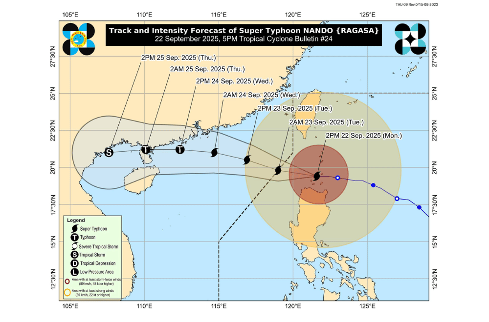
Super Typhoon #NandoPH made landfall over Panuitan Island in Calayan, Cagayan afternoon on Monday, September 22, 2025, and has started moving away from the Babuyan Islands, PAGASA said.
As of 4 p.m., the eye of Nando was over the coastal waters of Calayan Island, Cagayan, based on Aparri Doppler radar and other available data.
The super typhoon packed maximum sustained winds of 215 km/h near the center, gusts reaching 295 km/h, and a central pressure of 910 hPa. It was moving west at 25 km/h, with strong to typhoon-force winds extending up to 650 km from the center.
Areas under Signal No. 5 (typhoon-force winds, 185 km/h or higher)
- Babuyan Islands
Areas under Signal No. 4 (typhoon-force winds, 118–184 km/h)
- Southern portion of Batanes (Basco, Mahatao, Ivana, Uyugan, Sabtang)
- Northern portion of mainland Cagayan (Santa Ana, Santa Praxedes, Claveria, Sanchez-Mira, Pamplona, Abulug, Ballesteros, Aparri, Buguey, Santa Teresita, Gonzaga, Camalaniugan)
- Northern portion of Ilocos Norte (Pagudpud, Burgos, Bangui, Dumalneg, Adams)
Areas under Signal No. 3 (storm-force winds, 89–117 km/h)
- The rest of Batanes
- Central portion of mainland Cagayan (Lal-Lo, Gattaran, Baggao, Alcala, Santo Niño, Lasam, Allacapan, Rizal, Amulung, Piat)
- Northern and central portions of Apayao (Flora, Santa Marcela, Pudtol, Luna, Calanasan, Kabugao)
- The rest of Ilocos Norte
Areas under Signal No. 2 (gale-force winds, 62–88 km/h)
- The rest of mainland Cagayan
- Isabela
- The rest of Apayao
- Abra
- Kalinga
- Mountain Province
- Ifugao
- Northern portion of Benguet (Mankayan, Buguias, Bakun, Kibungan)
- Northeastern portion of Nueva Vizcaya (Diadi)
- Ilocos Sur
- Northern portion of La Union (Sudipen, Bangar, Luna, Balaoan, Santol)
Areas under Signal No. 1 (strong winds, 39–61 km/h)
- Quirino
- The rest of Nueva Vizcaya
- The rest of Benguet
- The rest of La Union
- Pangasinan
- Aurora
- Nueva Ecija
- Bulacan
- Tarlac
- Pampanga
- Zambales
- Northern portion of Quezon (General Nakar) including Polillo Islands
PAGASA warned of life-threatening storm surges exceeding 3 meters in Batanes, Cagayan including Babuyan Islands, Ilocos Norte, and Ilocos Sur.
A Gale Warning is in effect over the seaboards of Northern Luzon, with seas reaching up to 14 meters over Batanes and Babuyan Islands and 12 meters over Ilocos Norte. Sea travel is dangerous for all vessels.
The Southwest Monsoon, enhanced by Nando, will continue to bring strong to gale-force gusts over Metro Manila, Central Luzon, CALABARZON, Bicol Region, MIMAROPA, Visayas, and Mindanao. By Tuesday, gusts will persist over most of Luzon, Visayas, and Zamboanga Peninsula.
Nando made landfall over Panuitan Island in Calayan, Cagayan at around 3 p.m. and is expected to exit the Philippine Area of Responsibility morning on Tuesday, September 23.
PAGASA said Nando has reached its peak intensity, though a slight increase in strength is not ruled out. The typhoon is forecast to start weakening within 24 hours as it moves over the West Philippine Sea.
Authorities urged residents and local disaster officials to prepare for severe winds, coastal flooding, and possible evacuations in high-risk areas.
