


A new weather disturbance is expected to enter the Philippine Area of Responsibility (PAR) evening on Tuesday, September 23, 2025, just hours after Super Typhoon #NandoPH moved out toward the West Philippine Sea.
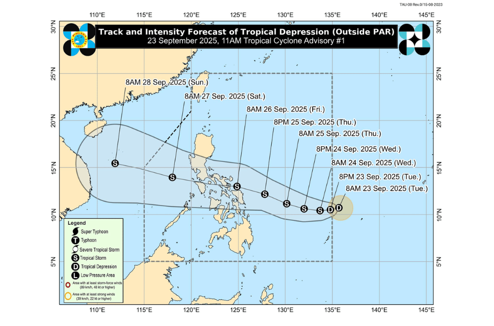
In its 11 a.m. advisory, PAGASA said a low-pressure area east of Southern Luzon developed into a tropical depression while outside PAR.
As of 10:00 a.m., the system was spotted 1,075 kilometers east of Eastern Visayas, packing maximum sustained winds of 55 km/h and gusts reaching 70 km/h.
The tropical depression, to be named Opong once inside PAR, was moving west at 35 km/h and may gradually strengthen into a tropical storm by Thursday, September 24. PAGASA said the system could further intensify, possibly reaching higher storm categories.
Inside PAR, Opong was projected to track west-northwest, approaching Eastern Visayas and Southern Luzon by Friday morning. It may cross the Bicol Region, CALABARZON, and MIMAROPA between September 25 to 26, before exiting PAR by evening on September 27.
With its path still uncertain, PAGASA warned of possible Signal No. 2 over parts of Southern Luzon and Eastern Visayas, with the chance of Signal No. 3 if the storm intensifies further. Heavy rains were expected to begin affecting parts of Eastern Visayas by September 25.
Meanwhile, Super Typhoon Nando maintained its strength over the West Philippine Sea after exiting PAR early Tuesday, September 23.
As of 10:00 a.m., its center was estimated at 385 kilometers west-northwest of Calayan, Cagayan, carrying maximum sustained winds of 185 km/h and gusts of up to 230 km/h.
Wind signals remained hoisted over Northern Luzon, though PAGASA said these could be lifted later in the day as Nando continued to head toward southern China.
The state weather bureau reminded the public and disaster officials to monitor updates on Opong’s progress while also staying alert for heavy rains from the southwest monsoon still being enhanced by Nando.
