


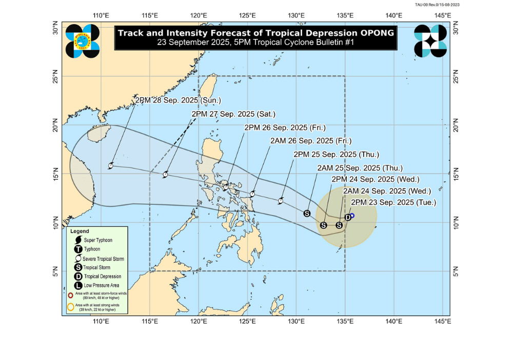
Tropical Depression #OpongPH has entered the Philippine Area of Responsibility (PAR) and is now moving slowly across the Philippine Sea, with PAGASA expecting it to head toward Eastern Visayas and Southern Luzon in the coming days.
As of 4 p.m. today, the storm’s center was spotted 1,045 kilometers east of Northeastern Mindanao.
It carries maximum sustained winds of 55 km/h, gusts of up to 70 km/h, and is moving west-southwest at 10 km/h. Though still relatively weak, its wide reach extends strong winds up to 360 kilometers from the center.
PAGASA said Opong is unlikely to affect local weather in the next 36 hours. However, heavy rains may begin by Thursday, September 25. By morning on Friday, September 26, the storm could pass close to or make landfall over Northern Samar, before tracking across Southern Luzon until late Friday or early Saturday, September 26.
Tropical Cyclone Wind Signal No. 1 may be raised as early as tomorrow over Eastern Visayas and the Bicol Region.
If Opong strengthens as expected, Signal No. 3 could be issued in some areas later this week. The system is forecast to intensify into a severe tropical storm by Thursday afternoon while still over sea.
Aside from Opong, winds enhanced by the combined effect of two weather systems will bring strong to gale-force gusts across large parts of Luzon, Visayas, and Mindanao over the next three days.
Moderate to rough seas are expected in Eastern Visayas and Northeastern Mindanao starting Thursday, with possible storm surge warnings in coastal areas of Southern Luzon and Eastern Visayas.
Authorities urge communities in at-risk areas to stay alert, especially those living in flood- and landslide-prone zones.
