


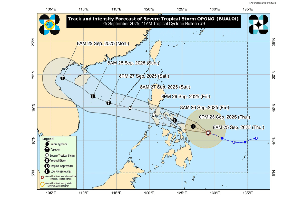
Severe Tropical Storm #OpongPH held its strength as it moved closer to the Philippines on Thursday, September 25, 2025, with PAGASA warning of heavy rains and strong winds over parts of Eastern Visayas and Bicol Region.
At 10 a.m., the storm’s center was spotted 335 kilometers east of Guiuan, Eastern Samar. Opong packed maximum sustained winds of 110 kilometers per hour, gusts of up to 135 kph, and was moving west-northwest at 25 kph. Its winds extended up to 430 kilometers from the center.
Areas under Signal No. 2 (gale-force winds, 62–88 km/h)
- Camarines Norte
- Camarines Sur
- Catanduanes
- Albay
- Sorsogon
- Northern portion of Masbate (Aroroy, Baleno, City of Masbate, Mobo,Uson, Dimasalang, Palanas, Cataingan,Pio V. Corpuz) including Ticao and Burias
- Northern Samar
- Northern and central portions of Eastern Samar (Can-Avid, Maslog, San Policarpo, Taft, Dolores, Jipapad, Oras, Arteche, Sulat, San Julian)
- Northern and central portions of Samar (San Jorge, San Sebastian, Villareal, Zumarraga, Matuguinao, Pinabacdao, Almagro, Calbayog City, Talalora, Jiabong, Pagsanghan, City of Catbalogan, Gandara, Motiong, Santo Niño, Tagapul-An, San Jose de Buan, Santa Margarita, Tarangnan, Calbiga, Daram, Paranas, Hinabangan)
- Northern portion of Biliran (Almeria, Kawayan, Maripipi, Culaba)
Areas under Signal No. 1 (strong winds, 39–61 km/h)
- Central and southern portions of Isabela (Alicia, San Mateo, Aurora, Ramon, Naguilian, Dinapigue, San Guillermo, Luna, City of Cauayan,Echague, Angadanan, Benito Soliven, City of Santiago, Reina Mercedes, San Agustin, San Manuel, Cabatuan, Gamu, San Isidro, Cordon, Jones, Burgos, San Mariano, Palanan)
- Quirino
- Nueva Vizcaya
- Ifugao
- Southwestern portion of Mountain Province (Bauko, Sabangan, Tadian)
- Benguet
- Southern portion of Ilocos Sur (Sugpon, Alilem)
- La Union
- Pangasinan
- Aurora
- Nueva Ecija
- Tarlac
- Zambales
- Bataan
- Pampanga
- Bulacan
- Metro Manila
- Rizal
- Cavite
- Batangas
- Laguna
- Quezon
- Romblon
- Marinduque
- Occidental Mindoro
- Oriental Mindoro
- Calamian Islands
- The rest of Masbate
- The rest of Eastern Samar
- The rest of Samar
- The rest of Biliran
- Leyte
- Southern Leyte
- The Northern portion of Cebu (Daanbantayan, Medellin, City of Bogo, Tabogon, San Remigio, Borbon, Sogod, Tabuelan, Catmon, Tuburan, Carmen, Danao City, Asturias, Compostela) including Camotes and Bantayan Islands
- The northern portion of Negros Occidental (City of Escalante, Toboso, Calatrava, Sagay City, Cadiz City, Manapla, City of Victorias, Enrique B. Magalona, Silay City, City of Talisay)
- The northern portion of Iloilo (San Dionisio, Batad, Balasan, Carles, Sara, Concepcion, Ajuy, Lemery, Barotac Viejo, San Rafael, Banate, Anilao, San Enrique, City of Passi, Bingawan, Calinog, Lambunao, Dueñas, Dingle)
- Capiz
- Aklan
- Northern portion of Antique (Libertad, Pandan, Sebaste, Culasi, Tibiao, Barbaza, Bugasong, Laua-An, Caluya)
- Siargao Island
- Bucas Grande Islands
- Dinagat Islands
Over 200 mm of rain is expected until Friday, September 26, in Northern Samar, Eastern Samar, Samar, Biliran, Sorsogon, and Masbate.
Heavy rains will also spread to Quezon, Bicol, Romblon, Leyte, and parts of the Visayas.
By Friday into Saturday, rains are forecast over Marinduque, Mindoro, Batangas, Cavite, Laguna, Quezon, and Metro Manila.
PAGASA warned of very rough seas, with waves up to 11 meters high off Catanduanes, Albay, Sorsogon, and Northern Samar. Sea travel is dangerous in these areas, and fishermen and small boats are advised to stay in port. A storm surge of 1 to 3 meters is also possible in low-lying coastal areas of Bicol, Samar, Leyte, Metro Manila, and parts of Southern Luzon.
Opong may either pass close to Northern Samar or make landfall in Bicol by Friday morning or early afternoon, before crossing Southern Luzon and exiting into the West Philippine Sea on Saturday, September 27. It may strengthen into a typhoon before landfall but is expected to weaken as it crosses land.
Authorities urged residents in flood-prone and coastal areas to prepare for possible evacuations and closely monitor updates from PAGASA and local officials.
