


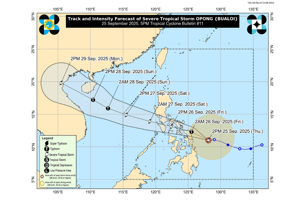
Severe Tropical Storm #OpongPH continued to move closer to Eastern Visayas on Thursday, September 25, 2025, with PAGASA warning it may strengthen into a typhoon before making landfall early Friday, September 26.
At 4 p.m., Opong’s center was spotted 195 kilometers east-northeast of Guiuan, Eastern Samar. It carried maximum sustained winds of 110 kilometers per hour and gusts of up to 135 km/h, while moving west at 15 km/h.
PAGASA said Opong is expected to make landfall over Northern Samar or northern Eastern Samar early Friday morning, before crossing toward Sorsogon in the Bicol Region later in the day.
It will then pass over the southern part of Luzon before exiting into the West Philippine Sea by Saturday morning.
Areas under Signal No. 3 (storm-force winds, 89–117 km/h)
- Sorsogon
- Northern portion of Masbate (Uson, Dimasalang, City of Masbate, Mobo, Palanas, Baleno, Aroroy) including Ticao and Burias Islands
- Northern Samar
- Northern portion of Eastern Samar (San Policarpo, Arteche, Jipapad, Oras, Dolores, Maslog, Can-Avid)
- Northern portion of Samar (Matuguinao, Calbayog City, San Jose de Buan)
Areas under Signal No. 2 (gale-force winds, 62–88 km/h)
- Eastern portion of Batangas (Padre Garcia, Ibaan, Rosario, Taysan, Lobo, San Juan, Batangas City)
- Southern portion of Quezon (Pitogo, San Andres, Buenavista, Lucena City, San Francisco, Calauag, Pagbilao, Tiaong, Lopez, Catanauan, Mulanay, Guinayangan, Unisan, General Luna, Plaridel, Quezon, San Antonio, Alabat, Candelaria, Lucban, Sampaloc, Padre Burgos, Sariaya, City of Tayabas, Macalelon, Mauban, Dolores, Perez, Agdangan, Gumaca, Atimonan, San Narciso, Tagkawayan)
- Camarines Norte
- Camarines Sur
- Albay
- Catanduanes
- The rest of Masbate
- Marinduque
- Romblon
- Oriental Mindoro
- Central portion of Eastern Samar (Taft, Sulat, San Julian, City of Borongan, Maydolong)
- Central portion of Samar (San Jorge, San Sebastian, Villareal, Zumarraga, Pinabacdao, Almagro, Talalora, Jiabong, Pagsanghan, City of Catbalogan, Motiong, Santo Niño, Tagapul-An, Tarangnan, Calbiga, Daram, Paranas, Hinabangan, Santa Margarita, Gandara)
- Biliran
- Northwestern portion of Leyte (Calubian)
Areas under Signal No. 1 (strong winds, 39–61 km/h)
- The central and southern portions of Isabela (Alicia, San Mateo, Aurora, Ramon, Naguilian, Dinapigue, San Guillermo, Luna, City of Cauayan, Echague, Angadanan, Benito Soliven, City of Santiago, Reina Mercedes, San Agustin, San Manuel, Cabatuan, Gamu, San Isidro, Cordon, Jones, Burgos, San Mariano, Palanan)
- Quirino
- Nueva Vizcaya
- Ifugao
- Southwestern portion of Mountain Province (Bauko, Sabangan, Tadian)
- Benguet
- Southern portion of Ilocos Sur (Sugpon, Alilem)
- La Union
- Pangasinan
- Aurora
- Nueva Ecija
- Tarlac
- Zambales
- Bataan
- Pampanga
- Bulacan
- Metro Manila
- Rizal
- Cavite
- The rest of Batangas
- Laguna
- The rest of Quezon
- Occidental Mindoro
- Cuyo Islands
- Calamian Islands
- The rest of Eastern Samar
- The rest of Samar
- The rest of Leyte
- Southern Leyte
- The northern portion of Cebu (Daanbantayan, Medellin, City of Bogo, Tabogon, San Remigio, Borbon, Sogod, Tabuelan, Catmon, Tuburan, Carmen, Danao City, Asturias, Compostela) including Camotes and Bantayan Islands
- Northern portion of Negros Occidental (City of Escalante, Toboso, Calatrava, Sagay City, Cadiz City, Manapla, City of Victorias, Enrique B. Magalona, Silay City, City of Talisay)
- Northern portion of Iloilo (San Dionisio, Batad, Balasan, Estancia, Carles, Sara, Concepcion, Ajuy, Lemery, Barotac Viejo, San Rafael, Banate, Anilao, San Enrique, City of Passi, Bingawan, Calinog, Lambunao, Dueñas, Dingle)
- Capiz
- Aklan
- Northern portion of Antique (Libertad, Pandan, Sebaste, Culasi, Tibiao, Barbaza, Bugasong, Laua-An, Caluya)
Over 200 mm of rain may fall from Thursday until Friday in Northern Samar, Eastern Samar, Samar, Biliran, Sorsogon, Masbate, and Romblon.
100–200 mm of rain is expected in Quezon, Batangas, Bicol provinces, Marinduque, Mindoro, Aklan, Capiz, and Leyte.
Metro Manila, Laguna, Cavite, Rizal, Cebu, and Bohol may also get heavy rains of up to 100 mm.
By Friday into Saturday, very heavy rains are forecast in Marinduque, Mindoro, and Batangas, while heavy rains may also spread to Cavite, Laguna, Quezon, Romblon, and parts of Central Luzon.
Storm surges up to 3 meters high are possible in low-lying areas of Metro Manila, Central Luzon, CALABARZON, MIMAROPA, Bicol, and Eastern Visayas.
Very rough seas with waves up to 11 meters high are expected along the eastern coasts of Catanduanes, Albay, Sorsogon, and Northern Samar. Sea travel is dangerous for all vessels.
Authorities warned of floods, landslides, and storm surges, especially in low-lying and coastal areas. Residents in areas under wind signals were urged to prepare for possible evacuations and to closely follow local officials’ instructions.
