


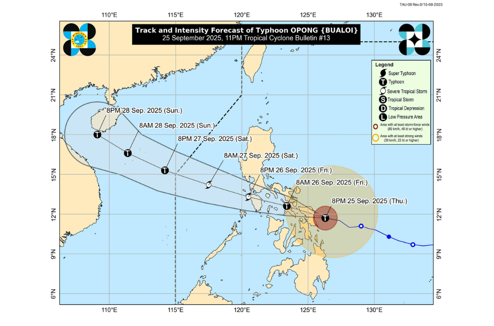
#OpongPH has intensified into a typhoon evening on Thursday, September 25, 2025, as it moved closer to Eastern Visayas, according to PAGASA.
At 10 p.m., Opong’s center was spotted near the coastal waters of Dolores, Eastern Samar. It carried maximum sustained winds of 120 kilometers per hour, gusts of up to 165 km/h, and was moving west northwest at 25 km/h.
Opong is forecast to make landfall in Northern Samar or northern Eastern Samar between midnight and early Friday, September 26, then head toward Sorsogon or Masbate later in the morning. It will continue across Southern Luzon before reaching the West Philippine Sea by early Saturday, September 27, where it may regain strength.
Areas under Signal No. 4 (typhoon-force winds, 118–184 km/h)
- Sorsogon
- Eastern portion of Masbate (Cataingan, Palanas, Dimasalang, Uson, Mobo, City of Masbate, Baleno, Aroroy, Mandaon, Milagros) including Ticao Island
- Northern Samar
- Northern and central portions of Eastern Samar (Jipapad, Maslog, Arteche, Oras, San Policarpo, Dolores, Can-Avid, Taft, Sulat, San Julian, City of Borongan)
- Northern and central portions of Samar (Hinabangan, Paranas, Motiong, San Sebastian, Jiabong, San Jorge, San Jose de Buan, Matuguinao, Calbayog City, Gandara, Santa Margarita, Pagsanghan, Tarangnan, City of Catbalogan, Santo Niño, Almagro, Tagapul-An)
Areas under Signal No. 3 (storm-force winds, 89–117 km/h)
- The rest of Masbate including Burias Island
- Albay
- Western portion of Camarines Sur (Buhi, Iriga City, Bato, Nabua, Balatan, Baao, Bula, Minalabac, San Fernando, Pamplona, Pasacao, Libmanan)
- Southern portion of Quezon (San Francisco, San Andres, San Narciso, Mulanay, Buenavista, Catanauan, General Luna, Guinayangan, Lopez, Macalelon)
- Marinduque
- Romblon
- Central and southern portions of Oriental Mindoro (Bulalacao, Bongabong, Bansud, Mansalay, Roxas, Gloria, Pinamalayan, Pola, Socorro, Victoria)
- The rest of Eastern Samar
- The rest of Samar
- Extreme northern portion of Leyte (Babatngon, San Miguel, Tacloban City, Barugo, Calubian, San Isidro, Leyte, Capoocan, Carigara)
- Biliran
Areas under Signal No. 2 (gale-force winds, 62–88 km/h)
- Catanduanes
- The rest of Camarines Sur
- Camarines Norte
- Central and eastern portions of Quezon (Pitogo, Lucena City, Calauag, Pagbilao, Infanta, Tiaong, Unisan, Plaridel, Quezon, San Antonio, Alabat, Candelaria, Lucban, Sampaloc, Padre Burgos, Sariaya, City of Tayabas, Mauban, Dolores, Perez, Agdangan, Gumaca, Atimonan, Real, Tagkawayan)
- Laguna
- Rizal
- Cavite
- Batangas
- The rest of Oriental Mindoro
- Occidental Mindoro including Lubang Islands
- Calamian Islands
- Metro Manila
- Southern portion of Bataan (Mariveles, Pilar, Limay, Orion, City of Balanga, Bagac)
- Eastern portion of Southern Leyte (Libagon, Anahawan, Hinunangan, San Juan, Silago, Saint Bernard, Hinundayan, Liloan, Pintuyan, San Francisco, San Ricardo, Sogod)
- Northern and central portions of Leyte (Tunga, Pastrana, Mahaplag, Matag-Ob, Tolosa, Palo, Mayorga, Julita, Dagami, Inopacan, Jaro, Abuyog, Santa Fe, Albuera, Villaba, La Paz, Palompon, Macarthur, Tabontabon, Tanauan, Merida, Ormoc City, Isabel, Javier, Dulag, Alangalang, Hindang, City of Baybay, Burauen, Tabango, Kananga)
- Northern portion of Cebu (Medellin, Daanbantayan, Tabogon, City of Bogo, San Remigio, Borbon, Sogod, Tabuelan, Tuburan, Catmon, Carmen) including Camotes and Bantayan Islands
- Extreme northern portion of Negros Occidental (Toboso, City of Escalante, Sagay City, Cadiz City, Manapla, City of Victorias, Enrique B. Magalona)
- Northern portion of Iloilo (Estancia, Carles, Balasan, Batad, San Dionisio, Concepcion, Sara, Ajuy, Lemery, Barotac Viejo, San Rafael, San Enrique, City of Passi, Bingawan, Calinog)
- Capiz
- Aklan
- Northwestern portion of Antique (Libertad, Pandan, Sebaste, Culasi) including Caluya Islands
- Dinagat Islands
- Siargao Islands
- Bucas Grande Islands
Areas under Signal No. 1 (strong winds, 39–61 km/h)
- Central and southern portions of Isabela (Alicia, San Mateo, Aurora, Ramon, Naguilian, Dinapigue, San Guillermo, Luna, City of Cauayan, Echague, Angadanan, Benito Soliven, City of Santiago, Reina Mercedes, San Agustin, San Manuel, Cabatuan, Gamu, San Isidro, Cordon, Jones, Burgos, San Mariano, Palanan)
- Quirino
- Nueva Vizcaya
- Ifugao
- Southwestern portion of Mountain Province (Bauko, Sabangan, Tadian)
- Benguet
- Southern portion of Ilocos Sur (Sugpon, Alilem)
- La Union
- Pangasinan
- Aurora
- Nueva Ecija
- Tarlac
- Zambales
- The rest of Bataan
- Pampanga
- Bulacan
- The rest of Quezon
- Cuyo Islands
- Northern portion of mainland Palawan (El Nido, Taytay, Dumaran, Araceli)
- The rest of Southern Leyte
- Eastern and central portions of Bohol (Getafe, Talibon, Bien Unido, Ubay, Trinidad, Pres. Carlos P. Garcia, Mabini, San Miguel, Alicia, Candijay, Anda, Guindulman, Pilar, Dagohoy, Danao, Buenavista, Inabanga, Clarin, Sagbayan, Carmen, Sierra Bullones, Duero, Jagna)
- Central portion of Cebu (Asturias, Danao City, Compostela, Liloan, Consolacion, Cebu City, Balamban, Mandaue City, Lapu-Lapu City, Toledo City, City of Talisay, Pinamungahan, Minglanilla, City of Naga, San Fernando, Aloguinsan, City of Carcar, Barili)
- Northern portion of Negros Oriental (Vallehermoso, Canlaon City, City of Guihulngan)
- Northern and central portions of Negros Occidental (Calatrava, Salvador Benedicto, San Carlos City, Silay City, City of Talisay, Bacolod City, Bago City, Murcia, La Castellana, Valladolid, Pulupandan, La Carlota City, San Enrique, Pontevedra, Moises Padilla, Isabela, Hinigaran)
- Central portion of Iloilo (Banate, Anilao, Dueñas, Dingle, Barotac Nuevo, Dumangas, Lambunao, Janiuay, Badiangan, Pototan, Mina, Zarraga, New Lucena, Cabatuan, Maasin)
- Central portion of Antique (Tibiao, Barbaza, Bugasong, Laua-An, Valderrama)
- The rest of Surigao del Norte
PAGASA said Opong, along with the southwest monsoon, will bring torrential rains that could trigger flooding and landslides. Areas outside the direct path may still experience heavy rains and strong winds.
Waves over 3 meters high may flood low-lying coastal areas in Metro Manila, Southern Luzon, Bicol, Samar, Leyte, Northern Mindoro, Romblon, Palawan, and parts of Visayas and Mindanao.
Very rough seas reaching up to 14 meters were forecast in Eastern Visayas and Bicol waters. All types of vessels are advised to remain in port.
Authorities urged residents in high-risk areas to prepare for possible evacuations, stay away from coastal waters, and follow instructions from local officials.
