


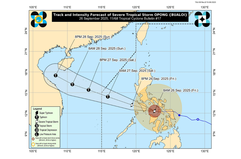
Severe Tropical Storm #OpongPH passed over Romblon morning on Friday, September 26, 2025, and is now moving toward the southern part of Mindoro.
At 10 a.m., Opong’s center was located near the coastal waters of Ferrol, Romblon, with maximum sustained winds of 110 kilometers per hour and gusts of up to 150 km/h. The storm is moving west at 35 km/h and brings strong winds up to 460 km from its center.
Opong is expected to make landfall over southern Occidental Mindoro by afternoon on Friday and cross the Mindoro Strait tonight before heading toward the West Philippine Sea. The storm is likely to remain a severe tropical storm until it exits Philippine waters, with chances of re-intensifying once over open sea.
Areas under Signal No. 3 (storm-force winds, 89–117 km/h)
- Batangas
- Marinduque
- Romblon
- Occidental Mindoro
- Oriental Mindoro
- Northern portion of Aklan (Makato, Tangalan, Kalibo, New Washington, Ibajay, Lezo, Malay, Nabas, Numancia, Batan, Buruanga)
- Caluya Island
Areas under Signal No. 2 (gale-force winds, 62–88 km/h)
- Southern portion of Zambales (San Marcelino, Subic, Olongapo City, Castillejos, San Antonio, San Narciso, San Felipe)
- Bataan
- Southern portion of Pampanga (Porac, Santa Rita, Guagua, Sasmuan, Macabebe, Masantol, Santo Tomas, San Simon, Minalin, City of San Fernando, Bacolor, Floridablanca, Apalit, Lubao)
- Southern portion of Bulacan (Obando, Paombong, Bocaue, City of San Jose del Monte, Bustos, City of Malolos, City of Meycauayan, Balagtas, Guiguinto, Pandi, Plaridel, Calumpit, Santa Maria, Hagonoy, Baliuag, Bulacan, Marilao, Pulilan)
- Metro Manila
- Rizal
- Cavite
- Laguna
- Southern portion of Quezon (Pitogo, Buenavista, Lucena City, Calauag, Pagbilao, Tiaong, Lopez, Catanauan, Mulanay, Guinayangan, Unisan, General Luna, Plaridel, Quezon, San Antonio, Alabat, Candelaria, Lucban, Sampaloc, Padre Burgos, Sariaya, City of Tayabas, Macalelon, Mauban, Dolores, Perez, Agdangan, Gumaca, Atimonan, Real, San Narciso, Tagkawayan, San Francisco, San Andres)
- Southern portion of Camarines Sur (Ocampo, Milaor, Nabua, Buhi, Baao, Cabusao, Bato, Camaligan, Pili, Sipocot, Pamplona, Ragay, Iriga City, San Fernando, Magarao, Minalabac, Del Gallego, Balatan, Libmanan, Naga City, Bombon, Bula, Canaman, Pasacao, Sagñay, Gainza, Lupi)
- Albay
- Sorsogon
- Masbate
- Calamian Islands
- Cuyo Islands
- Northern portion of Antique (Libertad, Pandan, Sebaste, Culasi, Valderrama, Barbaza, Tibiao, Patnongon, Laua-An, Bugasong)
- The rest of Aklan, Capiz
- Northern portion of Iloilo (Estancia, Carles, Balasan, Batad, San Dionisio, Concepcion, Sara, Ajuy, Lemery, Barotac Viejo, San Rafael, San Enrique, City of Passi, Bingawan, Calinog, Lambunao, Dueñas)
- Northern portion of Negros Occidental (Manapla, City of Victorias, Enrique B. Magalona, Cadiz City, Sagay City)
- Extreme northern portion of Cebu (Daanbantayan, Medellin) including Bantayan Islands
- Extreme western portion of Northern Samar (San Vicente, Capul, San Antonio)
- Extreme western portion of Samar (Tagapul-An)
Areas under Signal No. 1 (strong winds, 39–61 km/h)
- Pangasinan
- The rest of Zambales
- Tarlac
- Nueva Ecija
- Southern portion of Aurora (Dingalan, Baler, Maria Aurora, San Luis)
- The rest of Pampanga
- The rest of Bulacan
- The rest of Quezon
- Camarines Norte
- The rest of Camarines Sur
- Catanduanes
- The northern portion of Palawan (El Nido, Taytay, Dumaran, Araceli, San Vicente, Roxas)
- The rest of Antique
- The rest of Iloilo
- Guimaras
- Central portion of Negros Occidental (Calatrava, Salvador Benedicto, San Carlos City, Silay City, City of Talisay, Bacolod City, Bago City, Murcia, La Castellana, Valladolid, Pulupandan, La Carlota City, San Enrique, Pontevedra, Moises Padilla, Isabela, Hinigaran, City of Escalante, Toboso)
- Northern portion of Negros Oriental (Vallehermoso, Canlaon City, City of Guihulngan)
- Northern and central portion of Cebu (Asturias, Danao City, Compostela, Liloan, Consolacion, Cebu City, Balamban, Mandaue City, Lapu-Lapu City, Toledo City, City of Talisay, Pinamungahan, Minglanilla, City of Naga, San Fernando, Aloguinsan, Borbon, Carmen, Tuburan, City of Bogo, Tabogon, Catmon, Cordova, San Remigio, Sogod, Tabuelan, Barili, City of Carcar) including Camotes Islands
- Northern portion of Bohol (Getafe, Talibon, Bien Unido, Ubay, Trinidad, Pres. Carlos P. Garcia, Mabini, San Miguel, Alicia, Pilar, Dagohoy, Danao, Buenavista, Inabanga, Clarin, Sagbayan)
- The rest of Northern Samar
- The rest of Samar
- Eastern Samar
- Biliran
- Leyte
- Southern Leyte
PAGASA said Opong, combined with the southwest monsoon, will bring heavy rainfall:
- Over 200 mm: Occidental Mindoro, Oriental Mindoro, Romblon
- 100–200 mm: Palawan, Quezon, Laguna, Batangas, Masbate, Biliran, Marinduque, Aklan, Antique, Capiz
- 50–100 mm: Metro Manila, Bataan, Cavite, Rizal, Aurora, Isabela, Iloilo, Northern Samar, Eastern Samar, Samar, Sorsogon, Albay, Camarines Sur
Mountainous areas may see higher rainfall, increasing the risk of flash floods and landslides.
Moderate to high risk of coastal flooding with waves of two to three meters in low-lying areas of Bicol, Mindoro, Romblon, Masbate, Northern Samar, and Batangas.
Smaller surges of one to two meters are possible in Metro Manila, Bulacan, Pampanga, Aklan, Antique, Capiz, and other coastal provinces.
Very rough seas are expected in Romblon, up to nine meters, and rough seas of 3.5 to six meters in surrounding coastal waters. Mariners are advised to stay in port or seek safe shelter.
