


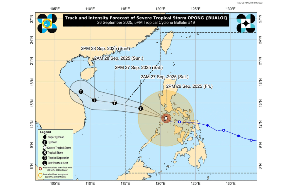
Severe Tropical Storm #OpongPH crossed Occidental Mindoro afternoon on Friday, September 26, 2025, and is now moving over the Mindoro Strait while bringing strong winds, heavy rains, and dangerous seas to several parts of Luzon and Visayas.
At 4 p.m., Opong’s center was spotted off the coast of Santa Cruz, Occidental Mindoro, with maximum sustained winds of 110 kilometers per hour and gusts of up to 150 km/h.
The storm is moving west-northwest at 35 km/h and is expected to reach the West Philippine Sea tonight, and is expected to leave the Philippine Area of Responsibility (PAR) by afternoon on Saturday, September 27.
PAGASA said it may strengthen back into a typhoon within 12 hours.
Areas under Wind Signal No. 3 (storm-force winds, 89–117 km/h)
- Occidental Mindoro
- Calamian Islands
Areas under Wind Signal No. 2 (gale-force winds, 62–88 km/h)
- Southern portion of Cavite (Magallanes, Mendez, Ternate, Amadeo, Naic, Maragondon, Alfonso, Tagaytay City, Trece Martires City, General Emilio Aguinaldo, Indang, Silang)
- Batangas
- Marinduque
- Oriental Mindoro
- Western portion of Romblon (San Jose, Odiongan, San Andres, Calatrava, San Agustin, Alcantara, Santa Fe, Santa Maria, Concepcion, Looc, Ferrol, Banton, Corcuera)
- Cuyo Islands
- Extreme northern portion of mainland Palawan (El Nido, Taytay, Araceli)
- Caluya Islands
Areas under Signal No. 1 (strong winds, 39–61 km/h)
- Pangasinan
- Southern portion of Aurora (Dingalan, Baler, Maria Aurora, San Luis)
- Nueva Ecija
- Tarlac
- Zambales
- Bataan
- Pampanga
- Bulacan
- Metro Manila
- Rizal
- The rest of Cavite
- Laguna
- Quezon
- Camarines Norte
- Camarines Sur
- Catanduanes
- Albay
- Sorsogon
- Masbate
- The rest of Romblon
- Northern portion of mainland Palawan (Dumaran, San Vicente, Roxas)
- Aklan
- Antique
- Capiz
- Iloilo
- Guimaras
- Northern portion of Negros Occidental (City of Talisay, Bacolod City, Bago City, Murcia, Valladolid, Pulupandan, La Carlota City, San Enrique, Pontevedra, City of Escalante, Cadiz City, Sagay City, Manapla, City of Victorias, Enrique B. Magalona, Silay City, Hinigaran)
- Bantayan Islands
Opong, enhanced by the southwest monsoon, will continue to bring heavy rains across Southern Luzon, Western Visayas, and Metro Manila.
PAGASA warned of possible flooding and landslides, especially in upland and low-lying communities.
Up to 3 meters of storm surge is possible in low-lying coastal areas of Metro Manila, CALABARZON, Mindoro, Marinduque, Romblon, Palawan, Masbate, Aklan, and Antique.
Very rough to high seas up to 9 meters around Occidental Mindoro, with waves of 4 to 6 meters in nearby provinces. PAGASA advised all vessels to remain in port as sea travel is extremely risky.
