


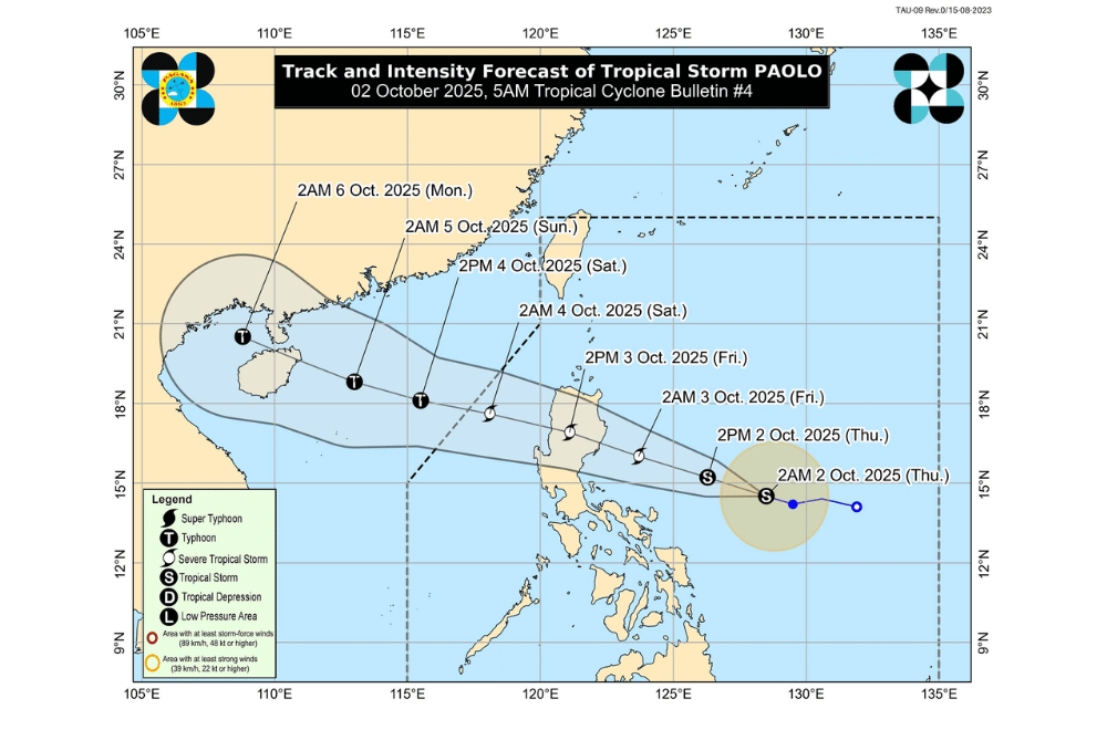
Tropical Depression #PaoloPH has strengthened into a tropical storm while moving closer to Northern Luzon, PAGASA said early Thursday, October 2. The storm may make landfall over Isabela or northern Aurora by Friday morning.
At 4 a.m., the center of Paolo was spotted 705 kilometers east of Infanta, Quezon. It was carrying maximum sustained winds of 65 kilometers per hour and gusts of up to 80 km/h, while moving west-northwest at 20 km/h.
PAGASA said Paolo may intensify into a severe tropical storm by Friday and could reach typhoon strength once it emerges over the West Philippine Sea after crossing Luzon.
It is expected to cross Northern Luzon on Friday, exit to the West Philippine Sea by afternoon, and leave the Philippine Area of Responsibility by Saturday morning, October 4.
Areas under Signal No. 1 (strong winds, 39–61 km/h)
- Mainland Cagayan
- Isabela
- Quirino
- Nueva Vizcaya
- Apayao
- Abra
- Kalinga
- Mountain Province
- Ifugao
- Benguet
- Ilocos Norte
- Ilocos Sur
- La Union
- Pangasinan
- Northern portion of Zambales (Palauig, Masinloc, Candelaria, Santa Cruz)
- Tarlac
- Nueva Ecija
- Aurora
- Northern portion of Bulacan (Doña Remedios Trinidad, San Miguel, San Ildefonso)
- Northern portion of Pampanga (Magalang, Arayat, Candaba, Mabalacat City)
- Northern portion of Quezon (General Nakar) including Polillo Islands
- Northern portion of Catanduanes (Pandan, Bagamanoc, Panganiban, Viga)
Downpours are expected to start affecting Northern and Central Luzon by Friday, with possible floods and landslides in high-risk areas.
Coastal flooding of 1 to 2 meters is possible within 36 hours in parts of Cagayan, Isabela, Aurora, Quezon, Camarines Norte, Camarines Sur, and Catanduanes.
Gale warnings may be raised this afternoon over the seaboards of Northern and Central Luzon due to rough to very rough seas.
PAGASA advised residents, especially in flood-prone and coastal areas, to take precautionary measures and follow instructions from local officials.
