


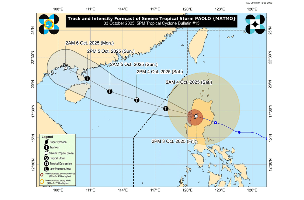
Typhoon #PaoloPH weakened into a severe tropical storm afternoon on Friday, October 3, 2025, as it moved out of Luzon and into the West Philippine Sea.
At 4 p.m., the center of Paolo was located off the coast of Santa Cruz, Ilocos Sur.
The storm carried maximum sustained winds of 110 kilometers per hour and gusts of up to 165 km/h. It was moving west-northwest at 35 km/h, with winds reaching up to 480 kilometers from its center.
Paolo is expected to exit the Philippine Area of Responsibility by Saturday morning. PAGASA said the storm may regain typhoon strength once it re-enters open waters.
Areas under Wind Signal No. 3 (storm-force winds, 89 to 117 km/h)
- Ilocos Sur
- La Union
- Southwestern portion of Abra (Boliney, Sallapadan, Bucloc, Tayum, Bangued, Langiden, Pidigan, San Quintin, Pilar, Luba, Manabo, Villaviciosa, San Isidro, Peñarrubia, Bucay, Tubo)
- Western portion of Kalinga (Tinglayan, Pasil)
- Western portion of Mountain Province (Besao, Tadian, Sagada, Bauko, Sadanga, Bontoc, Sabangan)
- Western portion of Ifugao (Hungduan, Tinoc)
- Benguet
Areas under Wind Signal No. 2 (gale-force winds, 62–88 km/h)
- Southern portion of Ilocos Norte (Nueva Era, Badoc, Pinili, City of Batac, Paoay, Currimao, Banna, Laoag City, San Nicolas, Sarrat, Dingras, Solsona, Marcos, Bacarra, Piddig, Pasuquin, Vintar, Carasi)
- Pangasinan
- The rest of Abra
- The rest of Kalinga
- The rest of Mountain Province
- The rest of Ifugao
Western portion of Isabela (Cordon, Ramon, San Mateo, City of Santiago, Quezon, Mallig, Roxas, Aurora, San Manuel, Cabatuan) - Northwestern portion of Quirino (Cabarroguis, Saguday, Diffun)
- Northern and central portions of Nueva Vizcaya (Dupax del Norte, Aritao, Santa Fe, Bayombong, Bagabag, Villaverde, Kasibu, Bambang, Diadi, Quezon, Solano, Dupax del Sur, Ambaguio, Kayapa)
- Northernmost portion of Nueva Ecija (Carranglan)
Areas under Wind Signal No. 1 (strong winds, 39–61 km/h)
- The rest of Ilocos Norte
- Apayao
- Batanes
- Mainland Cagayan including Babuyan Islands
- The rest of Isabela
- The rest of Quirino
- The rest of Nueva Vizcaya
- Aurora
- The rest of Nueva Ecija
- Tarlac
- Zambales
- Pampanga
- Bulacan
- Northern portion of Quezon (General Nakar, Infanta) including Polillo Islands
The storm may also bring storm surges reaching one to three meters in coastal areas of Ilocos Norte, Ilocos Sur, La Union, Pangasinan, Zambales, Cagayan, Isabela, and Aurora. Rough to high seas were reported across Northern and Central Luzon, making sea travel risky for all vessels.
Residents in affected areas were urged to stay alert, heed evacuation orders, and monitor updates from local officials and weather authorities.
