


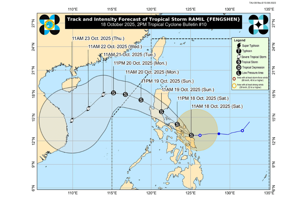
Tropical Storm #RamilPH weakened slightly as it moved westward toward land on Saturday afternoon, with its center spotted over the coastal waters of Laoang, Northern Samar, according to PAGASA.
As of 2 p.m., Ramil had maximum sustained winds of 65 kilometers per hour (km/h) near its center and gustiness of up to 80 km/h. It was moving west at 25 km/h.
Areas under Tropical Cyclone Wind Signal No. 2 (gale-force winds, 62–88 km/h)
- Northern portion of Aurora (Casiguran, Dilasag, Dinalungan)
- Polillo Islands
- Camarines Norte
- Catanduanes
- Northern portion of Camarines Sur (Tinambac, Siruma, Goa, San Jose, Lagonoy, Garchitorena, Caramoan, Presentacion)
- Extreme eastern portion of Albay (Rapu-Rapu)
- Northeastern portion of Sorsogon (Prieto Diaz)
- Northeastern portion of Northern Samar (Laoang, Palapag, Mapanas, Pambujan, San Roque, Mondragon, Gamay)
Areas under Tropical Cyclone Wind Signal No. 1 (strong winds, 39–61 km/h)
- Cagayan including Babuyan Islands
- Isabela
- Quirino
- Nueva Vizcaya
- Apayao
- Abra
- Kalinga
- Mountain Province
- Ifugao
- Benguet
- Ilocos Norte
- Ilocos Sur
- La Union
- Pangasinan
- The rest of Aurora
- Nueva Ecija
- Eastern portion of Bulacan (Doña Remedios Trinidad, Norzagaray, San Miguel, San Ildefonso, San Rafael, Angat)
- Eastern portion of Tarlac (Camiling, San Clemente, Santa Ignacia, Paniqui, Moncada, San Manuel, Anao, Ramos, Pura, Victoria, City of Tarlac, La Paz, Concepcion, Gerona)
- Eastern portion of Pampanga (Magalang, Arayat, Candaba)
- Northern and eastern portions of Quezon (Tagkawayan, Perez, Alabat, Quezon, Atimonan, Padre Burgos, Unisan, Gumaca, Plaridel, Agdangan, Pagbilao, Mauban, Calauag, Guinayangan, Lopez, Pitogo, Macalelon, General Luna, Catanauan, San Narciso, Buenavista, San Francisco, San Andres, Mulanay, General Nakar, Infanta, Real, Sampaloc)
- The rest of Camarines Sur
- The rest of Albay
- The rest of Sorsogon
- Burias Island
- Ticao Island
- The rest of Northern Samar
- Northern portion of Eastern Samar (San Policarpo, Arteche, Oras, Dolores, Maslog, Jipapad, Taft, Can-Avid)
- Northern portion of Samar (Matuguinao, San Jose de Buan, Calbayog City, Gandara, Santa Margarita, Pagsanghan, San Jorge, Tagapul-An, Almagro, Santo Niño, Tarangnan, Paranas, City of Catbalogan, Jiabong, Motiong)
Ramil is forecast to make landfall or pass close to Northern Samar by early afternoon, then move toward Catanduanes this evening. Based on its current movement, landfall over Albay or Sorsogon has also become more likely.
It is expected to cross mainland Bicol and Polillo Islands before making another landfall in Aurora by Sunday, possibly over northern Quezon or southern Isabela instead.
Afterward, the storm will move across Northern Luzon and may exit into the West Philippine Sea by Monday morning, where it could re-intensify.
Ramil’s rainbands and the easterlies are also expected to bring strong to gale-force gusts across areas not directly under any signal, especially in coastal and mountainous locations.
Today: Cagayan Valley, CALABARZON, Metro Manila, Ilocos Norte and Sur, Marinduque, Mindoro provinces, Masbate, Samar, and Biliran
Tomorrow (October 19): Central Luzon, CALABARZON, Metro Manila, Marinduque, Camarines Norte and Sur, and Catanduanes
PAGASA warned that Ramil could still strengthen into a severe tropical storm before landfall, which could raise wind signals to Signal No. 3 in affected areas.
A storm surge of 1 to 2 meters is possible within 48 hours over low-lying coastal areas in Isabela, Aurora, Quezon, Marinduque, Camarines Norte and Sur, Catanduanes, Albay, Sorsogon, Masbate, Romblon, Northern and Eastern Samar, Western Samar, Ilocos provinces, La Union, Pangasinan, and Zambales.
Sea travel remains risky due to rough to very rough seas, especially along the eastern seaboards of Bicol, Northern Samar, Aurora, and Cagayan. PAGASA advised all vessels to stay in port or seek shelter until conditions improve.
