


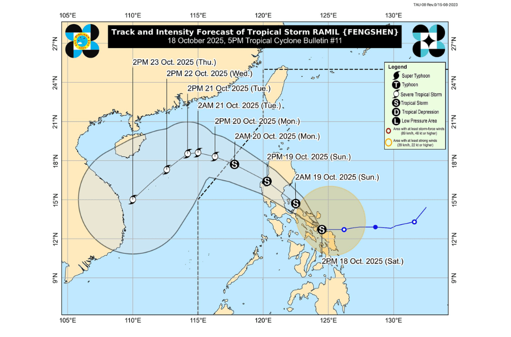
Tropical Storm #RamilPH made landfall over the coastal town of Gubat, Sorsogon on Saturday afternoon, bringing strong winds and heavy rains across Bicol and parts of Eastern Visayas, the state weather bureau said.
As of 4 p.m., Ramil was located over the coastal waters of Gubat, Sorsogon, packing maximum sustained winds of 65 kilometers per hour (km/h) near the center and gustiness of up to 90 km/h, according to PAGASA.
The storm was moving slowly westward, with strong to gale-force winds reaching up to 400 kilometers from its center.
Ramil is expected to continue moving across Bicol Region tonight and early Sunday, possibly crossing Polillo Islands before making another landfall in Aurora by Sunday morning or afternoon.
The storm may also re-intensify before its second landfall, as it remains close to the sea. After crossing Northern Luzon, it is forecast to move out toward the West Philippine Sea by Monday morning, where it could strengthen again.
Areas under Tropical Cyclone Wind Signal No. 2 (gale-force winds, 62–88 km/h)
- Southeastern portion of Isabela (Dinapigue)
- Southern portion of Quirino (Nagtipunan, Maddela)
- Southern portion of Nueva Vizcaya (Alfonso Castañeda)
- Northern and central portions of Aurora (Casiguran, Dilasag, Dinalungan, Baler, Dipaculao, Maria Aurora, San Luis)
- Polillo Islands
- Camarines Norte
- Catanduanes
- Northern and eastern portions of Camarines Sur (Tinambac, Siruma, Goa, San Jose, Lagonoy, Garchitorena, Caramoan, Presentacion, Sagñay, Tigaon)
- Eastern portion of Albay (Rapu-Rapu, Bacacay, City of Tabaco, Malilipot, Santo Domingo, Manito, Tiwi, Malinao)
- Northeastern portion of Sorsogon (Prieto Diaz, City of Sorsogon, Gubat)
- Northern portion of Northern Samar (Laoang, Pambujan, San Roque, Mondragon, Rosario, Lavezares, San Jose, Catarman, Bobon, Palapag)
Areas under Tropical Cyclone Wind Signal No. 1 (strong winds, 39–61 km/h)
- Cagayan including Babuyan Islands
- The rest of Isabela
- The rest of Quirino
- The rest of Nueva Vizcaya
- Apayao
- Abra
- Kalinga
- Mountain Province
- Ifugao, Benguet
- Ilocos Norte
- Ilocos Sur
- La Union
- Pangasinan
- The rest of Aurora
- Nueva Ecija
- Eastern portion of Bulacan (Doña Remedios Trinidad, Norzagaray, San Miguel, San Ildefonso, San Rafael, Angat)
- Eastern portion of Tarlac (Camiling, San Clemente, Santa Ignacia, Paniqui, Moncada, San Manuel, Anao, Ramos, Pura, Victoria, City of Tarlac, La Paz, Concepcion, Gerona)
- Eastern portion of Pampanga (Magalang, Arayat, Candaba)
- Northern and eastern portions of Quezon (Tagkawayan, Perez, Alabat, Quezon, Atimonan, Padre Burgos, Unisan, Gumaca, Plaridel, Agdangan, Pagbilao, Mauban, Calauag, Guinayangan, Lopez, Pitogo, Macalelon, General Luna, Catanauan, San Narciso, Buenavista, San Francisco, San Andres, Mulanay, General Nakar, Infanta, Real, Sampaloc)
- The rest of Camarines Sur
- The rest of Albay
- The rest of Sorsogon
- Burias Island
- Ticao Island
- The rest of Northern Samar
- Northern portion of Eastern Samar (San Policarpo, Arteche, Oras, Dolores, Maslog, Jipapad, Taft, Can-Avid)
- Northern portion of Samar (Matuguinao, San Jose de Buan, Calbayog City, Gandara, Santa Margarita, Pagsanghan, San Jorge, Tagapul-An, Almagro, Santo Niño, Tarangnan, Paranas, City of Catbalogan, Jiabong, Motiong)
Heavy to intense rainfall of more than 200 millimeters is expected over Northern Samar and Eastern Samar, while Sorsogon, Albay, Catanduanes, Camarines provinces, Quezon, and parts of Aurora and Northern Luzon may receive 100 to 200 millimeters of rain through Sunday.
Lighter but still significant rains are also expected in Metro Manila, CALABARZON, Central Luzon, and parts of the Visayas. Flooding and landslides are likely, especially in low-lying and mountainous areas.
A storm surge of 1 to 2 meters is possible within 36 hours in coastal areas of Isabela, Aurora, Quezon, Marinduque, Bicol Region, and Eastern Visayas. PAGASA warned that even areas outside the storm’s path could still experience storm surge and strong waves.
Sea conditions are very rough to rough, with waves reaching up to 5 meters along the eastern coasts of Isabela, Bicol, and Northern Samar, making sea travel risky for all vessels.
PAGASA reminded residents to stay alert for possible flash floods, landslides, and coastal inundation, and to follow evacuation orders from local authorities.
