


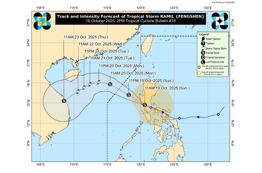
Tropical Storm #RamilPH maintained its strength afternoon on Sunday, October 19, 2025, as it moved across Central Luzon and neared the coastal waters of Zambales, where it is expected to exit land soon.
At 2 p.m., PAGASA located the storm’s center in the vicinity of Olongapo City, Zambales. Ramil packed maximum sustained winds of 65 kilometers per hour (kph) and gusts reaching 90 kph while moving west-northwest at 15 kph.
The weather bureau said Ramil will likely leave the Luzon landmass this afternoon and exit the Philippine Area of Responsibility (PAR) by Monday morning. Once over the West Philippine Sea, the storm could re-intensify into a severe tropical storm.
Areas under Tropical Cyclone Wind Signal No. 2 (gale-force winds, 62–88 km/h)
- Central and southern portions of Benguet (Itogon, Bokod, Atok, Kapangan, Tublay, La Trinidad, Baguio City, Tuba, Sablan)
- Central and southern portions of La Union (Rosario, Pugo, Tubao, Santo Tomas, Agoo, Aringay, Caba, Naguilian, Burgos, Bagulin, Bauang, City of San Fernando, San Juan, San Gabriel, Bacnotan, Santol, Balaoan, Luna)
- Pangasinan
- Nueva Ecija
- Bulacan
- Tarlac
- Pampanga
- Zambales
- Northern portion of Bataan (Dinalupihan, Hermosa, Orani, Samal, Abucay, Morong, Pilar, City of Balanga)
- Northern and central portions of Metro Manila (Caloocan City, Quezon City, City of Valenzuela, City of Marikina, City of Malabon, City of Navotas, City of Pasig, City of San Juan, City of Mandaluyong, City of Manila, City of Makati, Pateros, Taguig City, Pasay City, City of Parañaque)
- Northern and western portions of Rizal ( Rodriguez, Teresa, City of Antipolo, San Mateo, Taytay, Cainta, Angono)
Areas under Tropical Cyclone Wind Signal No. 1 (strong winds, 39–61 km/h)
- Cagayan including Babuyan Islands
- Isabela
- Quirino
- Nueva Vizcaya
- Apayao
- Abra
- Kalinga
- Mountain Province
- Ifugao
- The rest of Benguet
- Ilocos Norte
- Ilocos Sur
- The rest of La Union
- Aurora
- The rest of Bataan
- The rest of Metro Manila
- Quezon including Polillo Islands
- Laguna
- Cavite
- Batangas
- The rest of Rizal
- Occidental Mindoro including Lubang Islands
- Oriental Mindoro
- Marinduque
- Romblon
- Camarines Norte
- Western portion of Camarines Sur ( Del Gallego, Ragay, Lupi, Sipocot, Libmanan, Cabusao, Pasacao, Pamplona)
- Burias Island
PAGASA said Ramil will continue to bring heavy rains and strong winds in Central Luzon, Metro Manila, CALABARZON, and nearby areas. Even regions not under wind signals may experience strong gusts, especially along coastal and upland areas.
Storm surges of 1 to 2 meters are possible along the coasts of Ilocos Sur, La Union, Pangasinan, Zambales, Bataan, Batangas, Cavite, and Occidental Mindoro within 24 hours.
Sea travel remains dangerous as gale warnings are in effect for both eastern and western seaboards of Luzon.
Waves may reach up to 4.5 meters along the western coasts of Pangasinan, Zambales, Bataan, Batangas, and Occidental Mindoro.
Smaller vessels, including motorbancas, are advised not to sail due to very rough sea conditions.
