


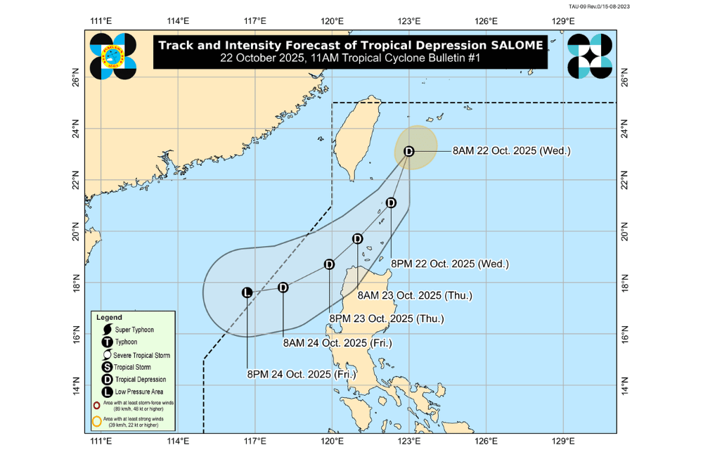
A tropical depression named #SalomePH has formed east of Taiwan and is moving southwest toward the northernmost parts of Luzon on Wednesday, October 22, 2025, according to PAGASA.
As of 11 a.m., Salome was located about 255 kilometers north-northeast of Itbayat, Batanes, moving southwest at 15 kilometers per hour. It has a maximum sustained winds of 55 kilometers per hour and gusts up to 70 kph.
Salome is expected to pass close to or over Batanes tonight into early morning on Thursday, October 23, then move near Babuyan Islands and Ilocos Norte by Thursday afternoon. The storm may leave the Philippine Area of Responsibility by evening on Friday, October 24.
Areas under Tropical Cyclone Wind Signal No. 1 (strong winds, 39–61 km/h)
- Batanes
- Western portion of Babuyan Islands (Calayan Is., Dalupiri Is.)
- Northwedstern portion of Ilocos Norte (Bangui, Pagudpud, Burgos, Pasuquin, Bacarra, Laoag City)
PAGASA said the highest wind signal expected for Salome is Wind Signal No. 1, but it could intensify into a tropical storm, which may require Wind Signal No. 2.
PAGASA warns that Salome may bring 50-100 mm of rain from today until tomorrow noon over Batanes. Rainfall may be higher in mountainous and elevated areas, and some locations could experience worsened impacts due to previous rains.
Gale warnings are in effect over the northern seaboard of Luzon. Mariners face:
- Very rough seas (up to 4.5 m): Batanes
- Rough seas (up to 4.0 m): Babuyan Islands
- Up to 3.5 m: Ilocos Norte and Ilocos Sur, northern mainland Cagayan, western Pangasinan
- Up to 2.5 m: Remaining coasts of Cagayan, Pangasinan, Isabela, La Union, and parts of northern and eastern Bicol and Visayas
Small vessels, including motorbancas, are advised not to sail until conditions improve.
